Quincy Vagell
EF4
This was an active day, but a bit of an odd storm chase as I passed in and out of Nebraska multiple times and spent time in four states over a relatively short span of time. (KS-NE-IA-MO)
I started the day in Salina, leaning toward the northern target of eastern Nebraska, but I was wary about the progged (favorable) environment in Kansas and CAM solutions lighting up south-central Kansas. Nonetheless, I wandered into southeastern Nebraska and as convection attempted to get going in far northeastern Kansas, I dropped into far northwestern Missouri to begin chasing.
A cluster of cells moved into southwestern Iowa, but never really organized all that well. I took a few photos and decided to shoot video to at least get something out of the chase. The footage has been sped up to 16x to give an idea of how a thunderstorm cluster evolved over Fremont County, Iowa:
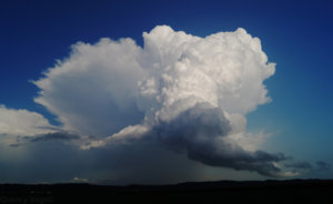
The updraft in the foreground was most interesting. It started off on a tilt and for a brief time looked like it was going to really ramp up, but it petered out a short time later.
After this, I was eyeing a small, discrete cell moving toward Omaha. Some other convection started going up in the area, but despite the seemingly favorable environment, storms once again struggled to organize very fast. I finally decided to blast west and take a shot with discrete convection west of York, Nebraska.
Of course, storms eventually did organize near Omaha around sunset and a brief tornado was reported by an off-duty NWS employee. I decided that the urban area combined with merging storms was less appealing than the prospect of discrete storms.
I watched a few briefly interesting storms to the west of York, but it was clear that by nightfall, these storms were displaced too far west from the more favorable environment near the Iowa/Nebraska border.
All in all, it was still a fun chase. I didn't exactly expect to drop into Missouri and watching storms in Iowa was neat. At one point in southeastern Nebraska, I was literally surrounded by updrafts in all directions. (storms near and northwest of Omaha, discrete convection in southern Nebraska and storms down in Kansas.
I started the day in Salina, leaning toward the northern target of eastern Nebraska, but I was wary about the progged (favorable) environment in Kansas and CAM solutions lighting up south-central Kansas. Nonetheless, I wandered into southeastern Nebraska and as convection attempted to get going in far northeastern Kansas, I dropped into far northwestern Missouri to begin chasing.
A cluster of cells moved into southwestern Iowa, but never really organized all that well. I took a few photos and decided to shoot video to at least get something out of the chase. The footage has been sped up to 16x to give an idea of how a thunderstorm cluster evolved over Fremont County, Iowa:

The updraft in the foreground was most interesting. It started off on a tilt and for a brief time looked like it was going to really ramp up, but it petered out a short time later.
After this, I was eyeing a small, discrete cell moving toward Omaha. Some other convection started going up in the area, but despite the seemingly favorable environment, storms once again struggled to organize very fast. I finally decided to blast west and take a shot with discrete convection west of York, Nebraska.
Of course, storms eventually did organize near Omaha around sunset and a brief tornado was reported by an off-duty NWS employee. I decided that the urban area combined with merging storms was less appealing than the prospect of discrete storms.
I watched a few briefly interesting storms to the west of York, but it was clear that by nightfall, these storms were displaced too far west from the more favorable environment near the Iowa/Nebraska border.
All in all, it was still a fun chase. I didn't exactly expect to drop into Missouri and watching storms in Iowa was neat. At one point in southeastern Nebraska, I was literally surrounded by updrafts in all directions. (storms near and northwest of Omaha, discrete convection in southern Nebraska and storms down in Kansas.

