Joined
May 18, 2012
Messages
292
Location
Gaines, MI
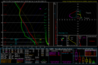
At least for now, late Saturday afternoon/early evening look conditionally like a severe weather opportunity across SC ND and parts of adjacent SD. An approaching upper level system and Pacific trough should allow for a surface low to develop out over eastern Montana, and as the GFS is depicting, pulling in fair amount of Gulf moisture (70 deg + progged near northern Lake Oahe), with SBCAPE over 5,000 just south of the WF. Good lapse rates, but with flow aloft looking anemic at only 20 kts my thinking for now would favor slow, right moving HP sups with some large hail. Wouldn't rule out a TOR with that hodo below. I'll be curious to see how the short range models deal with this as the day draws near.

Approximately Elgin, ND @ 0Z Sunday
6-11.PNG
 
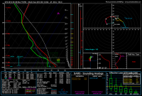
Yea, it is definitely looking like Saturday may warrant a chase up in far NW North Dakota near the Canadian border. Hopefully things can shift south a tad, seeing that I don't have a passport. The SPC has now highlighted that area for severe on their latest day 4-8 outlook. Per the GFS, it looks like there will be a nice surface low pressure area somewhere near the MT/ND/Canadian border by early evening on Saturday. This surface low is forecast to be sitting near 40-50 knot 500mb S/SW flow aloft. The GFS has been forecasting pooling dewpoints up into the low 70s directly ahead of the surface low, which is likely a bit overdone. It does seem plausible that low-mid 60s will be there though. This should put MLCAPE values somewhere in the 2-3000 j/kg range. T/Td spreads may be a bit high as storms first develop, but should lower as they always do towards sunset, and as the LLJ picks up. I am hopeful that there are a few supercells roaming across northern North Dakota on Saturday evening, as they may have decent tornado potential. I am not worried about HP storms because I really don't mind chasing HP storms. Given that the 300-200mb winds aren't going to be that strong, HP does seem likely. The shorter range models will start giving us a closer look at this event soon... Here is a decent looking sounding for ND on Saturday evening.

80fd9f81318a743f19627adf0fa0f52f.png
 
Last edited:
Noted the SPC mention in their overnight update. Liking the potential a little more today, but want to look at the 12Z to see how the NAM starts to delineate this. Agree on surface dews maybe being overdone as I'm not seeing anything close to 70s except for down into CNTL OK as of today. That's pretty far north for a system to transport that kind of moisture, but it's June, and I've seen that before.
 
Dewpoints in the 70s definitely seems like a bit of wishful thinking out of the GFS, it's been trending moist since the most recent tweaks to it's BL parameters. While there is likely going to be uninhibited southerly flow over the next three days, the weak aspect of the flow along with the main surface cyclone flirting with central Manitoba means we'll likely be looking at mid-60s unless we see random lee cyclogenesis further south along the Rockies.

Changing gears a bit, if people have passports, this might be the day to bring them along with the way things are trending. Looking like the lead impulse will be ejecting into southern Manitoba with the most favorable shear profiles being located where MT/ND and Canada meet. I highly doubt deep moisture makes it onto the High Plains of Montana but the elevation change may preclude a high-based failure of an event should moisture end up being paltry.
 
Just seeing the SPC's update from 0730Z to SLGT. Seems warranted to me based on what I'm seeing from the 0Z NAM. The environment storms firing in the warm sector near the surface low in ECNTL MT then moving into in NW ND and SE SK looks primed IMO. Over 300+ m2s-2 SRH, and 2500 MLCAPE, 60 kts of Bulk Shear, and great Lapse Rates. I was slightly concerned yesterday about 700mb temps hovering around 15-16 C, but with as well mixed as those air parcels will be (surface temps nearing 100 F), eroding it won't be an issue. Issue for me is finding a couple of buddies to spell me on that drive out and back (18.5 hours from Gaines to western ND). Going to see who I can round up, get the oil changed, and get a departure plan together.
 
I was slightly concerned yesterday about 700mb temps hovering around 15-16 C, but with as well mixed as those air parcels will be (surface temps nearing 100 F), eroding it won't be an issue.

lol wut? H7 temps of 15-16 C is basically unbreakable anywhere without epic forcing strength.

I see the precip signal in the GFS and SREF, though. Evolution of GFS forecast soundings in the vicinity of the front suggest pretty ridiculous levels of destabilization in the PBL due to heating. Soundings from Redig, SD show surface temps increasing from 86 to 102 between 18 and 21Z, with almost no temperature change in the ~800-550 mb layer. Color me impressed if that actually happens. However, this is also a situation where if it does happen, the PBL will also dry out insanely, leaving little threat for organized severe in that area. North of the front is where the moisture is, and it looks like substantial CIN is maintained throughout the day. I doubt the precipitation in the GFS is the result of surface based convection. However, the convectively contaminated hodographs coming out of SW ND are pretty entertaining.
 
Euro and NAM have +12C at 700 mb along the warm front Saturday. Most call that the 50/50 line on breaking the cap. At any rate I would consider along or north of that WF. I share the concerns above for south of the WF where 700 mb is +14C or hotter. Also agree the dews will mix out in south of the WF. I was going to say bring a passport just in case. However if that morning rain verifies, the WF should stay well within North Dakota. Keep in mind with midday clearing morning rain is an asset, leaving behind boundaries and locally higher helcity. The challenge will be finding a cell that does not entrain dry air from the south or cross the WF too fast. Chase target is tough, but I might say 1-2 cells east of the triple point.
 
Yeah 15C 700mb temps showing on the GFS and NAM both really worry me. That's about the only thing they are consistent in, 12Z NAM and 12Z GFS were so different today. 12Z GFS shows a further easterly track with the jet and a nice shortwave which could possibly kick things off, but the NAM seems to hold cap. Interesting that they are showing precip.

High risk high reward, I don't think at this point I'm willing to gamble 36 hours of driving for it.
 
The SREF spaghetti plots for H7 temps +15C have been consistently pushing into southern ND/MT with the 10C isotherm well into Manitoba. NCAR ensemble is also progging some less than favorable H7/H85 temps up that way. Not necessarily out of the ordinary considering the time of year/location, but unless some extraordinarily steep height falls and mid-level cooling occurs, you'll have to ride the aforementioned warm front in Manitoba/far northern ND.

Chasing Canada is also a crapshoot if you get too far away from the safety of partial WSR-88D coverage from the Dakotas and start having to rely only on EC radar data. RadarScope does a decent job of displaying it but there have been having issues with the data feed lately (specifically base products).
 
Last edited:
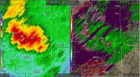
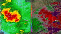
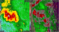
Unfortunately Baker MT was hit by the tornado on the 11th. That is a long way from any 88D. Billings, which has warning responsibility for that county, is > 180 nm from Baker. BIS, GGW and UDX radars are all 145-150 nm from the town. Below are captures from those 3 radars just before the tornado hit town. The radar beam is intercepting the storm at > 20,000 ft AGL. One can see the rotation pretty good on the BIS scan, but it was just one scan and the rotation was hardly noticeable before or after 0052Z.


kggw_20160612_0051_BR_0.5.png

kudx_20160612_0053_BR_0.5.png

kbis_20160612_0051_BR_0.5.png
 
Back
Top