• While Stormtrack has discontinued its hosting of SpotterNetwork support on the forums, keep in mind that support for SpotterNetwork issues is available by emailing [email protected].

2016-05-10 REPORTS: KY/IL

Joined
Jun 26, 2009
Messages
62
Location
Herrin, Illinois
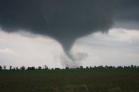
I originally planned on taking half a day at work and driving towards Evansville IN. However, morning convection rolled across Southern Illinois slower Tuesday morning than the overnight models indicated. But in doing so, a nicely oriented outflow boundary was laid out intersecting south-southwest surface flow.that had some pretty good CAPE building. I zipped down to Paducah, KY and saw this cell forming just west of the Mississippi in the MO bootheel on a strong flow line that 100 miles upstream fed into the biggest cell going. I jumped down to intercept and it almost immediately formed a huge hook and produced. I am just northwest of Mayfield looking southeast from a hook-slice position.


Attachments

  • IMG_0188.JPG
    IMG_0188.JPG
    120.2 KB · Views: 103
Mods, can we add Illinois to this thread? :)

I chased yesterday in my own backyard once again. I noticed a very subtle boundary on visible satellite that hung out all day south of I-80. Storms eventually formed in southern Henry County and well the rest is history. I'll copy and paste what I wrote up last night on Facebook (since its early and I don't want to rewrite a bunch lol).

Magic was in the air this evening over the wind farms of Galva....

I was under this developing storm as it went up. Watched a wall cloud quickly develop with it and then a rather crazy horizontal roll funnel with rapid motion. It eventually spit out a funnel which had pretty intense motion at the base of it, it condensed more than halfway down before I got in the car to get closer to it. I'm fairly certain it touched down as the wind rapidly increased as it moved over me in a roping stage to my east. Not to mention I could see very subtle amounts of dust under the feature on the horizon. Overall looked pretty classic with the RFD wrapping completely around it beautifully.

ac29fbefe7e04e9dc6df9a2624eba776.jpg
Funnel/Likely Tornado 2W of Galva, IL at 5:57pm

I stupidly only took like 4 or 5 photos before I got in the car to get closer. I was amazed at what was happening right in front of me. The motion at the base of the funnel was pretty intense. Nevertheless I got east last on for another AWESOME storm right at sunset which put out what looked like it was going to be a landspout tornado. Condensed almost 3/4 the way to the ground as I was driving west. I watched this storm wither away right at sunset beautifully before calling it a day.

Overall very satisfied with how things went yesterday considering the marginal outlook for storms and a SPC 0% risk of a tornado.

e61ab6a81cd1692bb4df60eb8579fe0d.jpg

Wall Cloud on LP storm outside Henderson, IL at sunset
0826570ee738824110a6e9b47c9ad7c9.jpg
funnel roping down near Victoria, IL


6643fe9a0ed6a0d5c36f4d007ee47883.jpg
Possible landspout outside Victoria, IL on second storm.


02b71bf9a4a1e249faa17c86152ce34b.jpg
LP storm at sunset

d80de24890ae3aba0b2331cdb52cf7ee.jpg

LP storm withering away at sunset

cd3a80b606abec162be41b4197d5fdb9.jpg
Last breaths of the storm with the moon to the left.
 
Back
Top