• While Stormtrack has discontinued its hosting of SpotterNetwork support on the forums, keep in mind that support for SpotterNetwork issues is available by emailing [email protected].

2016-04-24 REPORTS: KS/NE/IA

Joined
Jun 16, 2015
Messages
476
Location
Oklahoma City, OK
Just a very quick recap since I've been all over the country the past three days. Finally at a hotel tonight. These photos are from my phone, so hopefully the quality and formatting are okay.

Central to northeast Kansas was my target today and although there were no tornadoes from my vantage points, storms came close to producing a few times. There were plenty of photogenic moments and countryside views. I almost had my car done in by 2"+ hail, but made it out unscathed.

I started the chase in Hutchinson and had a visual on a funnel cloud just north of Holyrood. My view was partially obscured at times, but based on other reports, it did not appear to be a conclusive tornado.
image.jpeg
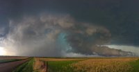
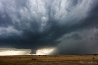
One of my favorite shots of the day was about 6 miles ENE of Ellsworth when the tornado-warned storm was maturing and featured substantial inflow.
image.jpeg
I watched the storm evolve for a while, but never really had a clear visual on anything touching the ground. It is possible that a tornado was rain-wrapped at times, as considering I tried to keep a distance easy to allow for photograph opportunities, I didn't have the closest views.

One such photo opp came near a ranch and I snapped off the following two pictures near Brookville.
image.jpeg
image.jpeg
The storm approached Salina and became progressively more junky looking on radar and visually.
image.jpeg
However, the initial embedded supercell ingested another cell from the south and there was a short time that the new storm tightened up its rotation a bit.

By the time I got to Junction City, I had a brief visual on a horizontal funnel/rotating appendage, but did not see it touchdown. In Ogden, the storm became tornado-warned again, but I saw no sign of any tornado there. With darkness increasing, I got back on I-70 west and assumed the chase was over...

After taking my eyes off radar just for a short time, I found myself driving into a hail core near Chapman with no way out. I braced for the worst, but managed to escape 2" and possibly larger hail with no noticeable car damage. This is a reminder that when in the Plains on severe weather days (even into the night), don't take your eyes off the radar for too long!
 

Attachments

  • image.jpeg
    image.jpeg
    129 KB · Views: 120
Last edited:
I started out at the dry line around Stafford on a southern cell, which broke apart when I got there. I decided to go towards the main storm around Salina, which everyone was on. About 7:00 p.m. I was 2 miles N on 143 when I saw these.0424161857.jpg 0424161858.jpg

It was getting late, and this dissipated. I looked towards the NW, and what I thought was scud became very interesting. Note the beaver tail in the0424161908a.jpg pic below.
0424161908.jpg 0424161901.jpg

When the wall cloud got closer, there was obvious rotation. It never produced, but still worth the chase from Parsons.

0424161927.jpg
 
Initially targeted Downs, KS and was hoping that I would be far enough south that a good target would pop in the vicinity or north of me. Wrong. I was on the right vector, but the storm of the day popped NW of Great Bend (soon to be several cells, of which one became dominant). I went east to Beloit and was trying to get to Ellsworth ahead of it. When I got to Interstate 70 it appeared I was a little late - so got eastbound to hopefully see into the back of the storm. My best opportunity at that was a couple of stops later on Brookville Rd. where I stopped just about a mile north of the Interstate. This was about the best shot I've seen (of mine) so far of the base and wall cloud.

d76a560467064769bc7f73661fb306b8.jpg

The sound of the hail core pounding things just to my north was a fearsome thing. Silver Dollar-sized hail dropped sporatically around me. I was on the very edge of the hail.

This storm appeared to change rapidly after this. It was moving east and back-building and turning into an even bigger HP monster as it approached Salina. I decided to abandon it and head north. There was a decent looking (smaller) storm SW of Belleville, KS that I thought I might be able to reach by Belleville. I succeeded (nearly). As I approached Belleville a couplet formed very close to Scandia, 10 miles WSW of Belleville. The storm vector was skirting north of Belleville and directly over Munden. The view from the south as this storm overtook Belleville was fearsome but I did not stop for photographs.

As I passed through Belleville the couplet was directly ahead (on Hwy 81) and the NWS tornado warned the storm, specifically mentioning Belleville and Munden. The couplet was now larger on screen. High precipitation (all rain). I was later told by a resident that power was lost all over Belleville and the tornado warnings did not sound. As the precip began to let up I was a couple miles north of Belleville and almost immediately noted debris caught in the barbed wire fence. A house was there with obvious tree damage surrounding it. A garage that had been between the house and Hwy 81 was now smeared south to north over the neighboring field. A couple of highway signs were snapped off at the intersection just to the SW of this property. I could see evidence from snapped tree limbs that the tornado was approximately 1/4 mile wide and I could see that it crossed at least 1 full country mile to the NE. SPC storm reports later reported damage to homes in Munden along with 2 injuries.

cc26405345cd069f8c9f88d19ad5ca79.jpg

5fc6c1dcad5303d9c882a0d9fb879b2a.jpg

d06e5071abe6a492cc95afe7dc400a56.jpg

A few more photos in my Flickr photostream.

All in all, I was pretty happy with my initial forecasting and target selection. I only wish I would have left earlier, a mistake I don't intend to repeat on Tuesday.
 
Initial Target was Pratt, KS. Storm arrived. Split. started to show promise. And then promptly dissipated to blue sky in record time. Caught back up with the new updraft that formed SW of the Great Bend area Tor warned storm, just south of Salina.

Followed that storm to Junction City and was watching while others were reporting tornadoes. I saw nothing, though I was at a pretty good distance and might have missed something below the hills or in the trees. There was a rotating pseudo-wall cloud above it but did exhibit much classic structure and features were a bit of a challenge to identify. I did encounter some 1.5-2" hail (I'll post pics from my phone later) just before those reports.

Doubled back to Bennington and then Salina for some fireworks.

 
Target was Pratt Kansas and got there just as the first cells formed ... it was obvious that was the wrong target so I blasted NE then North to Salina (along with a few other chasers) and got there in time to see it try to produce. I got caught in the hail along I-70 like most people and ended up just missing the tornado by Milford Lake. Hail fog at Milford Lake along with the smell of the pine trees was memorable. I drove around Manhattan reporting the flash flooding and then headed home. Oh yeah and I took a few tennis ball sized hail to my windshield and well we all know what that means.

Wasting drive to Pratt but the cows liked it there.
Pratt Cows.jpg

Salina trying to produce --- taken while driving
Salina Trying.jpg

Result of my interaction with tennis balls
Hail.jpg
 
Not a bad day for a couple hour drive. Didn't expect to see tornadoes given the lack of moisture. Targeted Hutchinson, KS, and stuck our ground until north storm went tornado warned and we watched the towers fail to get organized to its south. Basically followed it all the way east to Junction City where our chase was ended by a military barricade in the road. The tornado reports seemed highly questionable, given that we were directly underneath the updraft when they were both reported, and didn't see anything. One tornado was reported on the front flank of the storm. Overall a fun day.
91b9f2ddd2272efafac01878934abd80.jpg
40310aedc2e1e9f74ce27f5de054829f.jpg
e411d16be80ad44e432a1b21ccd72499.jpg
 
Found myself at a good vantage point on HWY 36 at the Cuba, KS turnoff. The first pic I took facing west at 6:19pm. The storm would have been south of Belleville, KS at the time. Not exactly sure if this was a tornado on the ground or not, as there was no warning out for Republic County at the time. Sure appeared that way though. The storm quickly intensified to supercell structure and was moving north towards Munden, KS, which is where the other photo taken(Pano photo attached). 20160424_181952_001.jpg 20160424_184929.jpg
 

Attachments

My target to start the day was Great Bend, which proved to be pretty spot on, but I was off on initiation by about 45 minutes so I was still a few minutes from the Ellsworth exit on I-70 when the cells popped up. Driving through Ellsworth I decided to stop a few miles on the other side of town since the dirt road network was pretty bad in that area. And realizing the tornado potential was fairly low, I wanted to sit back a ways and get some structure shots. Initially it was a beautiful storm in a picturesque part of Kansas, so I was quite happy sitting on a hill watching it. A wall cloud began to descend nose first in the shape of an elephant trunk and a few people reported it as a funnel, which I don't believe it was. There was little to no rotation but it was visually convincing. It then transitioned to a conical wall cloud before dissipating shortly afterward. The storm then went HP and became a huge hailer near I-70 and Salina.

Towards sunset I decided to stop following that grungy mess and went back to the west to try and get the sun setting below a couple supercells' rain shafts. It didn't disappoint.

5b826f42da10ac9d7ec5012ce1cc64a3.jpg

ec7c71c7e645d1d306965730df7ecb63.jpg

66e09c5e286bb2c16461c3f1b475f011.jpg
 

Attachments

  • DSC_1131.jpg
    DSC_1131.jpg
    525.2 KB · Views: 110
Targeted Hutchinson, KS (My home for my first 19 years of life) with fairly low expectations tornado wise but with hope of some nice supercells and maybe something more. So got about what I expected. Meandered west a few miles from hutch on the Quivira wildlife refuge blacktop and noted nice towers going up from Stafford to Hoisington. Perfect timing.

DSCN4289.JPG

Zigged and zagged northeast with these intital storms (soon to become the Ellsworth-Saline County tornado warned storm) knowing I could easily drop back south to the cells firing around Pratt if need be. Need did not be. Cell went tornaod warned in Northeastern Barton county and quickly produced the funnel looking NON-ROTATING wall cloud below, which others have noted.
DSCN4308.JPG

Got better organized SW of Ellsworth and at times had rapidly rotating wall clouds before occluding and trying again.

DSCN4327.JPG

Had a brief but clear shear funnel within this scud for about 15 seconds. I was too late on the trigger to capture it as I was trying to find a safe spot to pull over.

DSCN4322.JPG

Abandoned the storm around New Cambria as it was gettin way to HP for my liking.

Ended the day nicely on the this trailing LP west of Lindsborg, KS at sunset. 2 Photos below.

DSCN4359.JPG
DSCN4363.JPG

All in all a real pleasant Central Kansas chase-day, crowds got a little bad around Salina but I was leaving that storm at that point.
 
I headed out this day with a nice large area to choose from fairly close to home. In the end, I targeted the Salina area due to the better chance of better dewpoints making it up that far. The storm that became the tornado warned storm near Ellsworth formed when we were still at least an hour away and went tornado warned when we were still 30 minutes away. We headed west on I-70 and took an exit south to get around to the front of the storm. It was pretty frustrating how hilly it was in that area, but we finally found a spot on top of a hill that gave us a pretty good view. We watched the storm for quite a while as it slowly moved northeast and most of the time we were in a constant 40+ mph inflow. The storm had a beautiful inflow tail for a while and I feel it is possible there was a rain wrapped tornado back in the storm. Every once in a while you could faintly see something suspicious. My friend that was with took a pic and cranked the contrast up on his computer and it definitely looks questionable.
At any rate we followed the storm into Salina, and took I-70 east when it looked like the worst of the hail core was north of the interstate. We had a few larger stones thrown at us but nothing too big. We stayed ahead of the storm all the way to Junction City when it became warned for baseball sized hail while still to our west. We decided to let the storm go over I-77 and then start heading north to go home. We pulled right up to the edge of the storm and again had a few larger stones thrown our way. Suddenly the sirens started going off and there was supposedly a tornado reported over Milford Lake per law enforcement. We let the storm pass the highway and started heading north. We ran into some hail fog and a short distance where the hail was covering the road. We didn't find anything bigger than ping pong ball sized hail though. The coolest thing though was that between the hail, wind, and possible tornado in the area, there was a VERY strong scent of Pine or Juniper in the air. The roads in the area were lined with those trees and apparently the trees suffered enough damage to release a strong scent. I believe someone else in this thread mentioned smelling that too.

Video of the storm:

DSC_0021 (1).jpg DSC_0028 (1).jpg DSC_0033 (1).jpg DSC_0052.jpg
 
Back
Top