2016-03-30 REPORTS: TX/OK/KS/NE/IA/AR

Joined
Dec 22, 2005
Messages
232
Location
Chapman, KS
For all those who do not know, you post your reports/recollections/description of your chase in a REPORTS thread. At least that's how its been since 2005 as far as I know.

Nothing too great to share about today's chase for me I'm sure some Tulsa area guys have got some good stuff.

I changed my target from Emporia, KS to Arkansas City, KS this morning after seeing RAP and HRRR shunt any semblance of backing winds down to the oklahoma border. I got to Cowley county about 130pm and boom a bunch of pre-dryline (just barely) storms went up and actually didnt look too bad on radar at first so I jumped on a cell near Burden, KS and followed it to Moline, KS before it went elongated and outflow dominant (never looked too great to begin with). saw the Osage county Tornado warned storm only about 40 miles south of me but just didnt want to mess with that county at all, or any part of NE Oklahoma to be honest so left when the KS storms shitted out (about 5pm).

I already do not enjoy chasing Elk and Chautauqua counties in KS, and Osage county OK is a whole new level of awful.

Could've made it to the more prolific storms in NE OK if id gone for em but honestly I took one look at my Oklahoma topographical (yes I use real maps) and decided it would be more of a headache than it was worth.

Kinda wish I woulda given it a shot at this point even though it woulda meant an even later bed time lol.

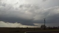
Here is one look at the Burden-Moline storm. would breifly/periodically drop a small wall cloud from the base but I was always re-positioning driving away from it when it would

DSCN4270.JPG
 
Last edited:
Initially targeted I-35 in Northern Oklahoma/ Southern Kansas. Got on the early storms that formed around 2 p.m and followed them all the way to Southeastern Kansas. I initially got on a cell near Bartlesville, OK that went tornado warned briefly before dying out. Luckily there was another to it's Southwest that was getting going pretty well. It eventually went tornado warned and I met up with it just West of Coffeyville, KS. I was treated to an amazing tornado. Definitely my best March chase to date and a great way to start the chase season.

4219f13a14468afdc32d21758c31ed44.jpg

 
Last edited:
This was the first time I've seen a confirmed tornado, and my first successful tornado intercept. It took me long enough, I've had an interest in chasing for over 20 years!

I live in the Tulsa metro, so that combined with the storm position and motion made this an easy chase. I was at a church function in midtown Tulsa but was watching the warnings on my phone. I knew I would want to chase it up I-44, so I left at 7:30 and headed that way as I listened to reports on Skywarn. My first indication I was getting closer was at I-44 and 161st St in Catoosa (site of the gas station destroyed in the deadly 1993 tornado). A picture from there looking north shows a classic bell shaped mesocyclone updraft. The next picture taken a mile east near the Hard Rock Casino shows the same updraft.

033016 Updraft 1.jpg
033016 Updraft 2.JPG

The next pictures are all video stills. The first shows a funnel over halfway to the ground, taken near where the Verdigris River crosses I-44. The tornado was near the Port of Catoosa at this time. The next is a still from video taken where I had stopped near I-44 and Hwy 266 a few minutes later. The view is of a funnel looking WNW about a mile away. At this point news helicopters were circling overhead viewing the funnel.

033016 Tornado 1.jpg
033016 Tornado 2.jpg

That funnel seemed to have dissipated and I talked for a minute or two with a couple of chasers who had stopped. Then we saw a new tornado which had quickly formed a couple of miles north of the earlier one, between Verdigris and Claremore. It caused several power flashes, illuminating the funnel a bluish color. Unfortunately I couldn't get a video still, the camera was moving too fast to get a good shot. I then chased it NE up I-44. The next two shots show the tornado backlit by lightning, first to the left of the highway, then as it crossed I-44 about 2 miles south of Claremore.

033016 Tornado 3.jpg
033016 Tornado 4.jpg

I saw light debris where it had crossed the highway but no damage to vehicles. I continued and pulled over with several others chasing it at the highway sign 1 mile south of the Claremore exit. At that point I was flabbergasted to see the multiple vortex tornado 1/2 mile to my east. I didn't intend to get that close! When I got out of my car to watch, I could hear it. It sounded like a distant waterfall. Unfortunately my video was too low contrast at that point to capture it, and I didn't watch it long enough to get a still backlit by lightning. (It was just after 8 pm by this point, nearing dusk.) I'll remember to calm down next time! At that point I was worried about a friend who lives in that area, so I called him to warn him to take shelter. I then exited I-44 and went to his house to check on him and his family near 500 Road and Dogwood Dr. There was fairly significant damage 3/4 mile north of his house. Trees had fallen and blocked 500 Road nearby. My friend and his family were fine, but the power was out. On the local news they were calling this the Tiawah tornado.

Anyway that's my story. There was a lot of great video of this series of tornadoes, all spawned by the Tulsa supercell, on the news this morning. It seemed to be most photogenic near the Tulsa airport as it approached Owasso. And I'm glad no deaths have been reported, and just a handful of injuries.
 
Last edited:
We missed the action down in Tulsa, but who doesn't like a mesoscale miracle? We caught a quick but pretty cone tornado west of Cedar Vale, Kansas; the tor spun up out of a little cell that was nothing on radar, but as we drove under it the rising motion was insane, RFD cut in and a big barrel funnel developed. We whipped around to watch as touched down very briefly a few times, then vanished.

Full chase log is here: http://highwaysandhailstones.com/storm-blog/march-30-2016/

Following the tornado we chased the tor-warned storms southeast of there, saw some nice structure, played in a bit of hail, then had dinner at Braums. Not a bad first chase of the year to shake off the dust!

CV_7_cropped.jpg
 
After spending most of the day traveling through a good chunk of Northern Oklahoma my chase partner Jake Riley and I sat at a gas station in Sapulpa for about an hour and contemplated heading back home declaring the day a bust. We watched a storm complex fire up on radar east of the OKC Metro. The supercell that would produce the tornadoes around Tulsa got our attention when it went through Mannford. After going trough downtown Sapulpa we headed north on highway 97 towards Sand Springs when the wall cloud came in to our view. We saw what looked like two areas of rotation underneath the wall cloud and a brief funnel. We made the mistake of continuing northward on 97 when we should have gotten on 412 and headed east not realizing there wasn't another adequate east option for another 5 to 10 miles further north. When the supercell was about 4 miles east of us we saw what looked like a cone funnel underneath the wall cloud. We attempted to do a hook slice in order to get ahead of the storm, but our attempt failed due to the bad road conditions on our east road (potholes galore and there were some spots that were flooded). We weren't able to catch up with it and we missed the big show (we drove past some of the damage that occurred around Claremore).

Had we taken highway 412 to the LL Tisdale Parkway and Gilcrease Expressway to highway 75 most likely I would have a video of a tornado to share, but this was another learning experience for myself and for Jake.

 
We targeted the cell near Cushing at around 6. Made camp on Prue road off HWY412. Caught the storm as it went severe and began rotating. We bailed back to 412 to head to HWY75 right after it went tornado warned:

(Sped up 10x)


We stayed with it as cycled then pulled ahead of it and got into position at 36th st N and 75 where it really got its act together. We left to head east about a minute before it touched down a mile north of us and caused some damage. We missed this due to trees but here up until we left:

(Sped up 5x)

36th turns into 46th and we ended up at HWY169 and my buddy got it touching down about 1.5 miles WNW of us (don't have the video uploaded yet) Due to traffic and the storm moving E then NE and back and forth, we retreated a mile south to 36th. We missed it crossing 169 but cuaght the funnel before it touched down east of Owasso then as it was on the ground through the car window.


Traffic killed us at that point as we parked and watched the storm move east to Claremore.

Great first chase of the year as it was in our backyard, we picked the right cell, and were never more than 2 miles from it until near the end. I'm hoping my buddy has a few better videos. I know he has some good pics.
 
VIDEO HIGHLIGHTS OF THIS EVENT:

MORNING FORECAST:

The original plan was to sit south of ICT and watch afternoon convection for possible supercells. The precip in SE OK made for a narrow corridor for ideal conditions for supercells in this area. Not to mention with the low being so progressive, winds weren't backing too well. My money shot was banking on NE OK/SE KS recovering from early precip in time before we lost daylight. The area looked primed for tornadoes for a couple hours per morning high res model runs.

EXECUTION:

We sat in Tonkawa, OK watching storms firing in the early afternoon. Some of the storms went severe warned and showed radar characteristics of being supercells. As we worked our way north to Winfield, KS...it was apparent that the storms in the vicinity weren't going to do anything. One storm that developed west of Perry, OK was staying consistant and visually had a nice backsheared anvil from our position. We decided to race towards it. It went tornado warned, but we failed to catch it in time near Copan, OK. More storms were firing to our south in a moderately unstable environment, and rolling eastwards towards an area of increased helicity. Our first tornado warned storm we intercepted was west of Caney, KS. It cycled a couple times before gusting out. My plan was to go east to US 169 then south...avoiding a storm between us and the rapidly developing Tulsa supercell. Turns out that storm between us ended up intensifying too, and becoming a tornado warned supercell. We sat north of Nowata, OK to watch it cycle. It tried really hard but became rain wrapped before we had a decent visual. We then went east where it cycled again, only this time it produced a 2 minute long multi-vortex tornado. After the tornado disappated, the storm slowly died off. We tried intercepting the southern storm east of Claremore, OK...but it disappated as well.

CONCLUSION: Glad I stuck to my original morning forecast/plan of action. It paid off big. Also glad I decided not to core the Nowata storm on US 75, as we wouldn't have had a good angle on it to intercept. Overall, GREAT SUCCESS!

b711f5ac496ad353ed755df5954924fe.jpg
 
Well it wan't a very exciting chase and unfortunately hit the Tulsa area, but got a few decent shots. I almost went North like most but decided to stay with my original target and be closer to the viewing area for 8. I haven't really messed with editing yet so I'll just post a couple links to what was sent in for sales and a couple of pics.My vehicle.jpg multiple.jpg me.jpg kinx.jpg Here's a 15 minute timelapse knocked down to around 30 something seconds.
And one more..
 
This was a back yard chase for me. I went into this chase with a very low confidence in how things would evolve. As the day progressed a pattern began to emerge, a familiar one for Tulsa in the past few years. I left Tulsa around 1:30 with a target near Ponca City, OK. Midday convection was ongoing in Tulsa, however clearing was evident just to the west. The dryline was located west of I-35. New cells were already popping along the dryline and this was a concern as we were just entering peak heating. Low-level winds shear was lacking, but was forecast by the NAM to improve around 00z. I seriously had my doubts about the NAM as it was an outlier for this event since it came into range. In fact this model spit out forecast soundings for Tulsa at 7pm WED which gave the same analog of a tornadic event that hit Tulsa County on 11/22/99. It did this four runs in a row! It was hard to ignore. The atmosphere was uncapped, but fortunately mid-level ascent was neutral and dryline convergence wasn't overly strong. This would keep things from over-initiating and probably played an important roll in how the atmosphere became conducive for tornado development later on. By the time I got to HWY 412/177 a developing supercell was approaching and a wall cloud was starting to take shape. I ended up chasing this cell across Osage County. It became tornado warned west of Pawhuska, but never produced. I let this cell go at Pawhuska as it appeared to be outrunning the instability and was already on a weakening trend.

By this point it was close to 5pm with only three hours of daylight left. Other cells were now developing along the dryline between Stillwater and OKC. Meanwhile, storms were developing further north along the OK/KS border. I decided to take a hard look at regional conditions to figure out which storm would have the best environment to work with. The storms which had moved through Tulsa round midday had wiped out the atmospheric instability for most of the afternoon, however skies had been clear for a few hours now and it looked as if the atmosphere was beginning to recover. In fact the CAPE values in Tulsa went from around 200 to 2000 in the hour preceding the tornado. An outflow boundary was present in this area with locally backed surface winds. Just west of Tulsa back to I-35 the atmosphere was already much more unstable and a number of cells were gaining strength. The southernmost cell coming out of OKC became severe while a handful of cells were clustered together with the northern one of the group looking to become the dominant player. I set up west of Keystone Lake and watched the developing storm morph into a supercell. A tornado warning was issued shortly thereafter. As the cell passed north of Sand Springs, a wall cloud developed and the storm began to exhibit much more impressive structure. I drove east on 412 into downtown Tulsa and then north on MLK Blvd. As the wall cloud drifted over North Tulsa a funnel developed aloft and eventually debris began to fly through the air. A tornado had formed. I tracked the tornado east maintaining a constant distance of no more than a mile to the southeast of the circulation. The tornado paralleled a road which stretched all the way into rogers County making for a rather easy intercept. At several points the tornado developed multiple vorticies, however never fully condensed until it was on the south side of Owasso. The tornado dropped down the backside of a ridge near the Tulsa Port of Catoosa and dissipated near Verdigris. The storm cycled another wall cloud immediately to the northeast. It was dark by this point. A new tornado touched down and morphed between a thick cone to a stovepipe to a wedge before dissipating over WIll Rogers Downs.

Here are a few images. These are the only pics I have of the tornado. I have video which needs editing. The first image is a map of the official tornado track across Tulsa and southern Owasso. The path marked in red is my intercept route. The order of the photos below corresponds with the locations of the numbers on the map.

View media item 1016
View media item 1013
View media item 1014
View media item 1012
View media item 1015
View media item 1011
 
Last edited:
Fun little chase , close to home. Caught a severe warned storm coming out of carter county , through Davis to Roff . Then it watched the storm die a quick death near Ada .
 

Attachments

  • 3-30 davis.jpg
    3-30 davis.jpg
    24.1 KB · Views: 120
Some good videos here. Pretty annoyed honestly...I was in Dallas for a few days with work when this happened. I chase these things all over the place and one comes right down my street on a low risk day while I'm in Dallas...blah
 
Back
Top