• While Stormtrack has discontinued its hosting of SpotterNetwork support on the forums, keep in mind that support for SpotterNetwork issues is available by emailing [email protected].

2015-07-16 EVENT: IA, IL

  • Thread starter Thread starter Joe Jeffers
  • Start date Start date

Joe Jeffers

Thinking that the SPC is letting this slip under the radar with only having a marginal risk issued. Supercell composites of 90 and with the level of wind shear I think there is a chance of some tornadoes. What's your input?
 
Hi Joe,

Not sure where you were seeing supercell composites of 90, but there is a lot of work that goes into a forecast. With that said, tomorrow doesn't scream tornadoes to me. You have decent flow at 500mb and even a 70kt jet streak up in Iowa at anvil level (300mb) per the NAM. This doesn't seem to coincide with the best LLJ (850mb winds) nor does the surface flow look at all conducive to tornadogenesis. Forecast soundings show the dreaded S shape hodographs in iowa, and very poor lapse rates across the area. While a marginal seems justified, I could very well see an upgrade to slight tomorrow. Either way, I don't think the SPC is letting this slip under the radar.
 
Thanks for your input with my limited training I am glad to hear from someone that is more knowledgeable on the subject. This was the composite I was looking at. Please if I am misreading let me know I would love to learn!
 

Attachments

  • image.jpg
    image.jpg
    169.6 KB · Views: 124
That is based on the SREF. I don't use that very often. It looks like that's the probability of supercell composite parameter, which is a probabilistic graphic on the probability of a supercell I would guess. I wouldn't disagree, as there is potential for supercell(s).

If you read the SPC discussion, it also cites lack of large scale ascent and poor lapse rates as a reason storms will be very isolated if any at all. If I were to play tomorrow i'd be on the warm front.
 
I was thinking if I were to chase based on that model and a couple more I would be just west of Davenport IA. Too far south for you?
 
Thanks for your input with my limited training I am glad to hear from someone that is more knowledgeable on the subject. This was the composite I was looking at. Please if I am misreading let me know I would love to learn!

When making a forecast (regardless of whether you're merely examining forecast products on your own or making a post somewhere about it) it's very important to know what you are looking at. For the SREF products (SREF = short range ensemble forecast system...more on that below) on the SPC site, the product title and description is found at the bottom center of the image. The image you posted shows two products: 1) the probability of supercell composite parameter exceeding 3 in shaded colors (the 90 refers to a 90% probability of exceedance) and 2) the 3 contour for ensemble mean SCP, denoted by the thick black dashed contour. This particular SREF forecast has a high degree of confidence on SCP exceeding 3 at 18 UTC tomorrow.

IMO it seems many members of this forum, and many storm chasers in general, are not versed in the nature of ensemble forecasting. That is somewhat disappointing, as ensemble forecasting is superior to deterministic forecasting and is the future of weather prediction. Perhaps I am biased since I have been studying it for years in grad school and it is at the center of my dissertation topic. However, ensembles will give you an extra dimension of information that deterministic forecasts can't. I think the nature of probabilistic forecasting is pretty intuitive, but it's new-school, so many chasers just haven't been introduced to it. I use the SREF frequently when making chase forecasts. It's very useful.

With that said, I think Ben hit on the main points pretty well. It seems unusual to continue to see this kind of support for organized storms this far south this late into the summer, but I think it aligns with the intensifying El Nino in the Pacific Ocean and is also consistent with the insane spring/early summer spring rains across much of the southern plains and Midwest. There's just not much capping, so with a little bit of EML and insane moisture quantity (dewpoints almost certainly to hang out in the mid-70s or above in parts of IA, MO, and IL) you get extreme instability. Add in the modest deep layer shear from a weak disturbance, and you generally have an atmosphere supportive of organized storms. It looks like low-level shear will be pretty limited except over far E IA and into IL, but a little separated from the extreme instability.

SPC categorical risk outlooks are based on more than just intensity of severe weather - they're also based on certainty (again, a probabilistic mode of thinking). Forecast predictability, especially on the convective scale, is practically nil at day 2 at any time of year, but especially during the summer when forcing is weaker and most events are controlled strongly by mesoscale factors rather than synoptic scale factors. There probably wouldn't be a problem with them including a slight risk somewhere across E IA, but I'm not sure they care quite as much about a one-category miss at this time of year (if a slight would even verify).
 
Thank you everyone for your informative input. I am a chaser that has self taught myself. I don't know nearly the information that both of you know. This is how I learn and become better at forecasting! It seemed weird with my knowledge that a slight risks wasn't at least issued but with your input I see why. Thank you both!
 
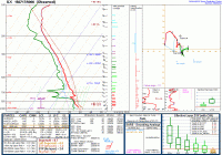
A somewhat impressive atmosphere sampled at ILX last night at 00Z with decent lower level shear and turning.

63abe04cd763738f6dee4303e86760ff.gif

The thing that still sticks out to me is that you're lacking a lot of MLCAPE, although I would guess that those values were a little higher to the west where the tornadoes were. Mid Level Lapse rates were pretty poor, leading to a long and mostly skinny CAPE profile. Lower level shear seems quite good though, which is what seemed to be missing earlier in the week. Just goes to show you that anything can happen with 'just enough' CAPE and shear.

Congrats to those that scored. I really didn't think this day had potential looking at the NAM the previous day. Still a lot to learn.
 
Looks like the meanest of them - the Cameron, IL tornado - has been rated EF2. Seems reasonable to me. I was surprised at how quickly some on social media were to jump at the possibility of this tornado being much stronger.

www.weather.gov/dvn/Summary_07162015

When watching the event unfold, there appeared to be a larger, stronger TDS associated with the tornado near Kirkwood, as CC dropped much lower and over a larger area than anything else that could be seen from KDVN during the event. What's weird is DVN splits the tornadoes near Kirkwood into two separate tracks with some space between them. The radar data showed a consistent CC hole from 6:55 - 7:08 PM, which is pretty close to the time period BETWEEN the two tornadoes rather than overlapping with either of them. I guess maybe it took that long for the updraft to loft the debris from the first tornado to the level where the beam would hit it, and the second one didn't loft debris as high despite being rated higher and occurring slightly closer to the radar. Guess that's why we use ground truth over radar estimates.
 
From my vantage point on the storm it was still dropping tornadoes in that "gap" they have on their survey. I contacted them about it and sent some video stills so perhaps they will review it.
 
I noticed at least five different funnels South of the main area of rotation. Some of those did touch the ground and become tornadoes. I was thinking the same thing with the preliminary storm reports is that they were missing some tornado touchdowns. I have sent my videos to everyone I know as well to help with that process. I am sure it's just a matter of time.
 
Back
Top