• A friendly and periodic reminder of the rules we use for fostering high SNR and quality conversation and interaction at Stormtrack: Forum rules

    P.S. - Nothing specific happened to prompt this message! No one is in trouble, there are no flame wars in effect, nor any inappropriate conversation ongoing. This is being posted sitewide as a casual refresher.

2024-04-16 EVENT: IA/MO/AR/IL

Brian R.

EF1
Joined
Apr 13, 2024
Messages
50
Location
North Chicago Illinois
Looking at the spc outlook for Monday the 15th, which keeps everything basically west and southwest of northern Illinois, and then for Tuesday the 16, where Illinois is likely going to be at least a slight risk..... I have to say I do not have total confidence in Tuesday being of much impact for northern Illinois as of yet where I am located at, however possibly slightly further west and southwest there may be some severe storms. My outlook is that we need to see if and how much of Monday's event will move into Illinois Monday evening and overnight, if any of it does, and how long cloud cover and precipitation lasts on Tuesday before any of us get too hyped over it, even though it has been on the spc page for several days now. Wondering what other's feelings are about Tuesday for northern Illinois.
 
Tuesday is a tough call. The surface pattern looks classic, but there is some weirdness going on upstairs that makes the mid-to-upper levels wonky over most of Iowa. Low-level shear and 3CAPE are great, so there ought to be tornadoes, but will you be able to see them with storms likely raining all over their own updraft area?

That was one of the nice things about 3/31/23, the upper levels of the hodographs were elongated and swept out far to the northeast (and practically off the chart) so you could tell (lack of) upper-level venting wasn't going to be an issue for viewing, given a discrete supercell.

Best overall hodographs appear to be in northern MO and again along the warm front in northern IL. But I really don't want to chase in MO and will storms fire before dark in IL? Much remains to be seen.
I'm thinking storms won't fire until evening, or even until after dark if they fire at all in Northern Illinois. All depends if we get precipitation overnight into Tuesday morning, and cloud cover sticks around, or is it going to be a clear rather warm day on Monday???
 
Was just looking at simulated radar models for Tuesday, and it is looking like it definitely will be a late evening overnight event, and looking at them.... it looks like storms will be weakening as they approach the Chicago metro area. Have to see how things look before making any plans to be out for it.
 
So much about Tuesday depends on how Monday ends up evolving RE ongoing storms. The main show Tuesday in IA/MO/IL will be with the second wave of storms, how those perform will depend on how fast the sun can come out behind the first wave. Some CAMs show that dry slot being rather narrow with not much time for recovery. The late-ness of Monday’s storms in Kansas would lend credence to that. If the cap holds upstream tomorrow, then Tuesday could end up with high-end potential - not only on the warm front (the best target) but farther south. The first morning visible satellite view will be important!
 
It's definitely gonna depend on what develops today (Monday) if anything at all does for northern Illinois. Was just out with my dog and here in Chicago it is clear blue skies and nice. Personally I think by the time it reaches the Chicago metro area Tuesday, it will be in the weakening stages, but again that all depends what develops late afternoon thru early morning.
 
Today in Iowa doesn’t look all that appealing to me. Mid/upper winds are largely meridional. The proximity of the tight, closed mid-level low concerns me - it seems whenever there is a fast-moving vort max like that, it’s an early day with widespread convection, not discrete supercells. Supposedly there will be a dry slot and some air mass recovery between rounds of convection. Most models do show a narrow axis of strong SBCAPE in the early afternoon, but I would still be worried about widespread convection, the unidirectional flow, and fast storm motions.
 
The state of the squall line in eastern KS and latest CAMs make it look like the first wave may evolve into a show from IA through southern IL/MO later this afternoon. Storms are shown remaining discrete in this area, and there is clearing ahead of it. My home target bias is manifesting heavily in an inclination to just get ahead of the line and stay just ahead on I-70 into St. Louis.
 
Looking at the simulated radar models on the HRRR the 00z thru 02z time frame, it is looking to be possibly moderately severe in the Chicago metro area. I think the main concerns for the Chicago metro area is going to be wind and large hail mainly. Also looks like they will be fast moving storms so not much risk of flooding.
 
There still remains uncertainty on the downstream environment. Visible satellite is showing an area of clearing working in ahead of the main line, downstream of the ongoing convection across N MO and SW IA. This will be the area of watch both for redevelopment further east along this line along with new development this afternoon between this line and the next forcing mechanism. Right now I'd say there is maximized tornado potential in vicinity of the warm from with this early convection but then later, if redevelopment occurs (some CAMs are showing discrete convection after 20z) a pocket of ambient MLCAPE, favorable SRH and low LCLs exists across NE MO, S IA and WC into NW IL that could promote tornadic potential there. That potential exists across the open warm sector as well as proximal to the surface WF, which may end up somewhere closer to the US 34 to I-80 corridors unless it is suppressed further south. The HREF and 3 km NAM seem to be sticking to the one and done scenario whereas the HRRR, ECMWF and other CAMs are showing quasi-discrete development after 21z, particularly along and north of the US24/US 136 corridors. Historically speaking, right moving warm front storms are always a safe bet in these setups if everything else comes together properly.
 
Virtual starting point: Ottumwa, IA. Virtual starting area is from Oskaloosa IA to Kirksville MO. I'm not out there this week.

Ottumwa is the north side hedge (2/3 of the way) for lunch and data. Easier to adjust south than north, esp fast storm motion. Things are moving quickly. Sit-down lunch might become fast food rush job. Goal is to position for either the warm front WF or outflow boundary OFB. Normally we like OFB, but Iowa loves to WF. Plus they may become one diffuse boundary with all the mixing and wind today.

Cell northeast of KC looks like an OFB work but it's getting close to the WF. Said cell(s) will likely maintain or create outflow. I would position closer to the WF in case that's it. No way to catch up from the south; so, be north at first. If the OFB ends up being it, adjusting south or just waiting for it would be relatively easy. Either way a classic dry line DL is coming out of Kansas. It's not just a Pacific front; it's warm and dry behind it. Moisture ahead is deeper than yesterday. Really both WF and OFB, plus other minor boundaries, could deliver at their intersections with the DL.

If the WF and OFB surge north the target might have to shift more into Iowa. However, if an outflow can anchor then northern Missouri is in play. Also, I know I'd chase east from the starting points above. IIRC all that terrain is OK. It's not Kansas, but it's not the Ozarks or eastern Oklahoma either. Good luck and be safe!
 
I think this question could go into a number of place, but since it features 4/16/2024 data and bears on the event I will post it here:

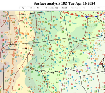
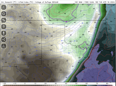
In the figures below, why are the 18Z surface analysis and NAM 18Z analysis output so different? I have been under the impression that the "model analysis" output should, at a minimum, reflect the actual conditions at the time of model initiation.

1713298020766.png1713297945815.png
18Z WPC Surface Analysis for 4/16/202418Z NAM F00 output for 4/16/2024 (CoD)

(I think I am about to get a major lesson in how to correctly interpret model data.)

4PM EDIT: I had a chance to check the OK Mesonet data and it tends to confirm the NAM 18Z F00 output with OK dewpoints in the 30F's and 40F's. So the issue appears to the WPC surface analysis as posted on the internet...and it is--the April 15 and April 16 18Z maps are the same.

(At this point I would delete this post if not for the fact that others have read it and it would seem odd for the post to just disappear. But if the moderators want to "disappear it" I would not be offended.)
 
Last edited:
Looking at storm reports from yesterday's event. Looks like Iowa was the place to be. Heard from some members on my chase team who went to Indiana, they got to see structure forming and awesome lightning show, but depending how you look at it, fortunately nothing produced any tornadoes. My area on the north side of Chicago was mostly very uneventful, except for some noise and a little lightning.... just enough to upset my furry friend.
 
Back
Top