• While Stormtrack has discontinued its hosting of SpotterNetwork support on the forums, keep in mind that support for SpotterNetwork issues is available by emailing [email protected].

2015-07-13 EVENT: IA/IL/IN/KY/MO

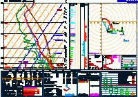
I think the low-level shear was just too meager. The 18z DVN and ILX (image below) soundings displayed this problem pretty well. Yeah, sure there's decent turning with the winds with height but, look at the speeds.
e188b23a0e32a4708dbdd0f3860f6285.gif

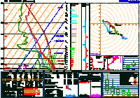
The 00z ILX sounding (image below) showcases this problem even further. The only time storms even looked somewhat tornadic was when they were near the outflow boundary that was leftover from the morning's convection. This outflow boundary would have provided increased helicity in the low-levels.
59a45b7f9447d49fb4b49a4bb5d30360.gif

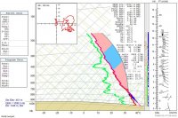
A few people are saying that the low-levels were too dry. While that may not help the situation, it doesn't explain the tornado in Kansas (00z sounding from Hesston, KS below) as the moisture in the low-levels was similar. The deviant storm-motion of the Kansas supercell lead to increased low-level helicity. This is likely why the storm was able to produce.
00df3ba3b2974901b4bd2e98a3ef4b9b._.jpg
 
The 00Z ILX sounding isn't very impressive when you look at the mixed-layer parcel. As I noted in my post yesterday, there was some dry air working in aloft (at 850 mb) from the west during the day. It appeared to show up on the 00Z ILX sounding, where the moisture whittled down very rapidly above the surface. In fact, that extreme moisture (surface dewpoint of 80 F) was only present at the surface. The resulting ML parcel only had 1185 J/kg of CAPE alongside 211 J/kg MLCIN. Yes, the surface parcel was pretty extreme, but you should not exclusively use the SB parcel in warm season cases since entrainment will reduce the theta-e of the parcel as it rises through the PBL. There was also 0 3-km CAPE at ILX, so despite the great 0-1 km shear for the time of year (25 kts), there just wasn't much the atmosphere could do with it. Last thing: it appears the OFB left by the morning MCS washed out across IL, thus leaving the area with only weak forcing/lift for storms. In fact, I think it was some sort of low-level rotating convergence center over N IL that spurred on most of the development.

The 00Z DVN sounding was a little less disappointing, but still has the same issues. However, it was also contaminated by the storms that went over just before sounding launch, so I attempted to reproduce what I think the sounding may have looked like with the cold pool removed and using observations at the peak of the day (91/80 was the highest I saw at KDVN):
fa6a48126ef27c7ecf525e0e1875147d.png

As you can see, the sounding may have had an MLCAPE of 4920 J/kg with no MLCIN since that moist layer was much deeper. Since this never actually happened, we'll never know for sure what may have transpired there. However, it does seem strange why the storms in E IA didn't do more. There were some issues with storm competition and seeding, but the first big one to go seemed to have trouble containing its outflow right from the start. Perhaps it was the high amounts of DCAPE that caused the storms to be outflow dominant.
 
A few people are saying that the low-levels were too dry. While that may not help the situation, it doesn't explain the tornado in Kansas (00z sounding from Hesston, KS below) as the moisture in the low-levels was similar. The deviant storm-motion of the Kansas supercell lead to increased low-level helicity. This is likely why the storm was able to produce.

I think that storm was tornadic because the hook was directly attached to the cold front the whole time. Plenty of localized horizontal vorticity there. The environmental horizontal vorticity was absolute crap and probably did not contribute to tornadogenesis in any way.
 
I think that storm was tornadic because the hook was directly attached to the cold front the whole time. Plenty of localized horizontal vorticity there. The environmental horizontal vorticity was absolute crap and probably did not contribute to tornadogenesis in any way.
As you said, the hook was likely attached to the boundary and was feeding off the horizontal vorticity. I guess I had overlooked that the hook was on the boundary. The storm's deviant motion may have allowed the hook to stay on the cold front but it likely wasn't the driving factor for tornadogenesis. I'm just not completely sold on moisture being the main issue because as you also wondered in your other post, why didn't the storms near Davenport (which had much greater moisture depth) do anything?
 
Back
Top