John Farley
Supporter
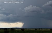
Caught a couple of very impressive supercells this afternoon in eastern New Mexico. The first one I basically circled, approaching it initially from Tucumcari then viewing it from the east, north, and west as it slowly drifted from just north of Wagon Wheel to north of Tucumcari. Much of the time the storm was over unchaseable terrain in the Mesalands between Wagon Wheel and Tucumcari, but from a little west of Mosquero to just south of Roy I got good views of it until the precipitation eventually obscured the updraft area. In this picture, taken from a little south of Roy looking west, it looks like there could be a tornado, but actually this was condensation that was created by a microburst getting pulled back into the updraft. This happened several times.
I passed through Wagon Wheel about an hour after the storm, and the snowplows were still at work on the hail accumulation north of town:
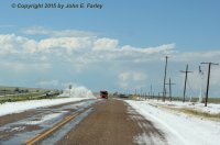
The highway department reported a foot of hail accumulated at one point a couple miles north of Wagon Wheel. By the time I got there, there wasn't still that much, maybe 4 or 5 inches, but there were still some stones larger than quarters, probably 1.25 - 1.5".
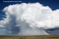
Dropping south on I-25 and then a little east of Las Vegas, I got a nice view of another less intense, but very pretty supercell that formed near Las Vegas and drifted very slowly to the southeast:
Days like this prove that you don't always need tornadoes to have a great chase.
I will eventually get a full report posted; have a lot of video and additional photos to get through in the meantime.

I passed through Wagon Wheel about an hour after the storm, and the snowplows were still at work on the hail accumulation north of town:

The highway department reported a foot of hail accumulated at one point a couple miles north of Wagon Wheel. By the time I got there, there wasn't still that much, maybe 4 or 5 inches, but there were still some stones larger than quarters, probably 1.25 - 1.5".
Dropping south on I-25 and then a little east of Las Vegas, I got a nice view of another less intense, but very pretty supercell that formed near Las Vegas and drifted very slowly to the southeast:

Days like this prove that you don't always need tornadoes to have a great chase.
I will eventually get a full report posted; have a lot of video and additional photos to get through in the meantime.
