• While Stormtrack has discontinued its hosting of SpotterNetwork support on the forums, keep in mind that support for SpotterNetwork issues is available by emailing [email protected].

2015-05-06 Reports: KS, NE, OK, TX

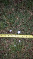
Didn't see any tornadoes this day, however I did manager to chase 2 tornado warned supercells in Northern Oklahoma. Kind of in between both clusters of tornado reports (NC KS and C OK). Oh well. The Pond Creek, OK supercell was beautiful and great to chase. Despite strong rotation and a great looking wall cloud, never seemed to be able to get down to the surface. Had a couple funnel clouds with it and some large hail (golf ball size) and then headed back west for another storm near Fairview, Oklahoma at sunset. This was another great storm. All in all, hard to consider a day with beautiful storms over open country, a bust. Here are a few of my shots from this day, Enjoy!

Enid%20Supercell_zpspamenqnc.jpg

Southwest of Pond Creek, Oklahoma

Pond%20Creek%20Supercell_zpssoaij6ew.jpg

Some decent structure with the same storm later on

Fairview%20OK_zpsm7bkwgar.jpg

Fairview, Oklahoma sunset supercell!
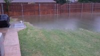
 
Didn't have to chase these ones as they came to me. The first supercell that went through NW Norman lifted about a mile south of me. I found a picture online that showed the wall cloud directly overhead. This matches up with the increased winds and decreased precip/hail that I could hear from inside my Fraidy Hole. A tremendous amount of rain came with the first storm. Below is a picture of the new pond in my back yard (about 10" deep) in relation to my shelter. Water line got too close for comfort. This storm brough hail of around 1 inch.

20150506_182309.jpg

20150506_182301.jpg

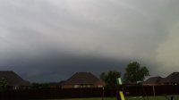
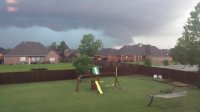
I watched the second supercell roll in from my backyard and second story window. I was able to see the base. First image is from around 7:10 pm and the second from about 7:20 pm. At this time the storm wasn't torn warned. Once it got north of me it prompted the tornado warning near Will Rogers, Along I-240, and then at I-35 and SW 44th. As I watched the base I saw several lowerings (not funnels) appearing all around the main meso.

20150506_191032.jpg 20150506_192025.jpg
 
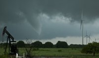
My total count from this day was 3 tornadoes with 2 maybenadoes from the second supercell that threatened the OKC Metro. The first maybenado occurred around Bridge Creek after meeting up with Ben Holcomb (I don't have video of it but Ben has it on his YouTube channel).

The second occurred near Tuttle towards the end of our chase. It looked as though the funnel made it close enough to the ground to generate ground circulation, but I couldn't tell with the trees blocking my view. Plus so far the LSR only indicated wind damage around Tuttle around the time I shot this funnel/possible tornado. I'm not ready to add this one to the other tornadoes I've seen just yet.

 
Last edited:
Back
Top