• While Stormtrack has discontinued its hosting of SpotterNetwork support on the forums, keep in mind that support for SpotterNetwork issues is available by emailing [email protected].

2015-05-06 Reports: KS, NE, OK, TX

JeremyS

EF4
Joined
Mar 12, 2014
Messages
305
Location
Omaha, NE
Figured I'd start a reports thread since today was quite the day and hopefully a fair amount of us were out there to capture it. I'll post more later as it's late and I need to head to bed.
Saw a total of 7 tornadoes in northcentral Kansas today, including a large wedge near Courtland Kansas that turned into a long track tornado all the way into Nebraska. Was within a quarter mile of it at one point, the closest I have ever been to a tornado. It was amazing, and yes I was being careful and safe!
Quite the day throughout the plains, but I am a bit surprised at how many tornadoes were dropping today in northern Kansas.
Pics and hopefully some video soon!
 
I saw my first tornado today! I've gone out chasing maybe 5 times without any luck, but that changed today. I parked myself 8 or so miles NE of Chickasha, OK and watched as the Bridge Creek tornado formed right in front of me.

Picture here: https://twitter.com/michael73072/status/596168285432913921
mgAACvs.jpg


Video from my Nexus 5:

Video from my dash cam:

Here's a map of my location history. The red dot to the north is where I took the picture and video from.
12f3ff4402.png
 
On only my second chase ever... Saw my first tornado as well as an area of anticyclonic rotation.. Fun chase. Had a diffeq exam that I stayed up all night for, then went to bed afterwards at about 10:30 and woke up in the afternoon realizing there was a tornadic supercell heading towards the Moore/Norman area.. Decision easily made.

No pics of value, and sorry there wasn't much to add, but definitely a fun chase!
 
Here's some of my timelapse footage from yesterday near Blanchard, Oklahoma and a few stills to go with it.


Attachments

  • BlanchardSupA_B_CFinal copy.jpg
    BlanchardSupA_B_CFinal copy.jpg
    575.8 KB · Views: 258
  • NewCastleSupFinal copy.jpg
    NewCastleSupFinal copy.jpg
    523.2 KB · Views: 245
  • BlanchardSupA_B_CFinal copy.jpg
    BlanchardSupA_B_CFinal copy.jpg
    575.8 KB · Views: 227
  • BlanchardSupFinal copy.jpg
    BlanchardSupFinal copy.jpg
    382.7 KB · Views: 245
  • NewCastleSupFinal copy.jpg
    NewCastleSupFinal copy.jpg
    523.2 KB · Views: 247
While chasing storms in Throckmorton, TX yesterday I drove south of town and noticed construction vehicles parked on the side of the road because telephone poles had been blown down and were lying in the grass. As I looked up there was a guy waving in the middle of the road (no signs or warning posted and it was a 75 mph zone). I swerved to go past him and didn't think anything else of it other than he wanted everyone to slow down even though there was no debris in the road. I chased some more for about an hour and then came back and was hoping to see the guy just to apologize for swerving around him (he looked a bit excited when I passed him earlier). As I drove back a police officer pulled me over, asked me to get out of my vehicle and proceeded to handcuff me and tell me that I was under arrest for assault. He called the construction person who turned out to be the county attorney and as I waited for him in handcuffs, he showed up and we discussed it and i was released with just a citation for failure to yield right away to an emergency vehicle. I learned that you have to slow down to 20 mph for all emergency vehicles in Texas including police and any vehicle with flashing blue and red lights. Just one of the many adventures in North Texas, although I did get to see the wedge tornado that dropped just west of town at night.
 
I broke two streaks with this chase.
-717 days between legit tornado sightings (last: 19 May 2013)
-First legit tornado on a solo chase

I'm going to count six total tornadoes, although almost all of them were pretty weak and short lived.

Also, I have a love-hate relationship with Caddo County, Oklahoma. The terrain and roads are absolute s--t in portions, yet I've seen multiple tornadoes there in relatively good areas of the county, including this day.

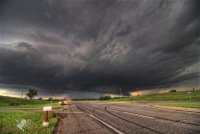
I was busy debating whether or not to target near Hutchinson, KS or southwest OK around lunchtime when I saw a small storm go up right off the Wichita mountains...and it was rotating. Knowing that clearing was developing from west to east and convective temps were pretty low, I knew I needed to get west. I left Norman around 1 PM in pursuit of that first storm, but it was dying as I worked my way west on OK-9.

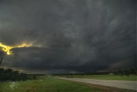
I noticed the backing winds and convergence developing ahead of the dryline in SW OK, so I continued west through Chickasha towards Anadarko. While chilling in Anadarko I saw the mean looking cumulus structure on the storms that were going up southwest of town. So I went south on OK-8 towards Cyril. Once I got west of town I saw the wall cloud forming to my WSW; it just had that look to it. I said to myself as I sped west on OK-19, "I'm a few minutes away from breaking my streak." Indeed I was. Only a minute or two after I stopped on a hill three miles east of Apache, the first tornado touched down a half mile west of me. It wasn't particularly photogenic and it took several minutes before it finally condensed, but it was my first tornado in almost two years, and it was fairly close - close enough to hear the whooshing sound it made as it spun through empty fields northwest of me. Unfortunately I had forgotten to check my camera settings until nearly the end of this tornado. I had left them from a previous chase when I was shooting in the dark, so nearly all of my photos of this tornado are overexposed and unrecoverable :(.

The rope out was kinda neat, but I missed much of it going east. I repositioned back on OK-8 northwest of Cyril in time to see the second tornado as a nub funnel to my NW.

150506_027-web.jpg

I jumped on county road 1410 eastward to stay with the storm, which continued to display a low hanging rotating wall cloud. A few miles east of the turn, I witnessed a third tornado, this one multiple-vortex:

150506_031-web.jpg
It was such a wonderful feeling to be sitting just behind a tornado in a strong RFD wrapping rain and small hail around at probably 40-50 mph, shaking my car a little.

I began to get worried at this point based on the track the storm was taking and how good it was starting to look. I began a series of phone calls with my wife, who works in OKC, about the potential for a strike on the OKC-OUN corridor. It was at this point that I decidedly shifted my chase strategy to get east and ahead of the storm if I needed to sprint back to my apartment in Norman and get my animals to shelter (they were home alone with no way to protect themselves); if that hadn't been an issue I would've stuck more towards being directly behind the tornado - to the south and west of it.

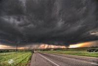
Meanwhile I tracked east and north while watching the evolution of the meso at close range. I eventually wound up getting back into Chickasha from the west. I continued east, then northeast of Chickasha on 62, then 92. The storm really seemed to struggle to put the final piece in and produce a tornado despite a consistent low-level mesocyclone. I eventually wound up near the intersection of E1300 Rd. and N2920 Rd. just southeast of I-44 as the big tornado formed. The rotation and vertical motion within the wall cloud were among the strongest I'd ever seen from close range. Again, however, that tornado took its sweet time getting organized.

150506_047-web.jpg

It spat out a satellite funnel. Could never confirm ground contact.

150506_065-web.jpg
Almost immediately after it began to condense near the ground, what was probably an occlusion downdraft or DRC (the beginning of a really wet hook) started to obscure it in rain. This was about the last view I had of it before I lost it:

150506_074-web.jpg

There was no way I was going to try to keep going north with the condition the gravel/mud road was in and the car I drive, so I turned east to try to work my way back towards Blanchard. I got swept up in the hook and RFD as it came flying around the south side of the tornado. I knew there was a tornado probably 1 mile north of me but I could not see it at all and driving was rather hazardous at this point.

Knowing that the tornado had become nearly stationary over the interstate, I decided to try to punch back into the hook by going north on OK-76 from Blanchard. Unfortunately the police had blocked off the highway north of town. I may have briefly caught a glimpse at the left side of it at this point, but I never saw the big one.

I was forced to go back to town and take US 62 up to highway 9 again (amazing the circles I end up driving on chases). I tried messing around with the hook again southeast of Newcastle, but was forced to flee east when the visibility plummeted. It's a good thing I didn't stick around, since the storm cycled and ended up producing another tornado not far from where I had been. This was the tornado that formed just west of Norman. I happened to catch the top of it above the trees from near the Riverwind Casino.

150506_079-web.jpg
This was the most agonizing moment of the chase, as I was forced to accept that this storm was going to keep pushing more east than north and was likely to produce a tornado in Norman. At first I felt powerless to do anything and was going to ride it out at this location. But when I remembered just how slow it was moving, I decided to make a run for it. I jumped back on I-35 and flew up to my exit. The interstate was eerily empty, although there were a large number of cars stopped on the entrance/exit ramps.

I managed to get to my apartment probably just as the Norman tornado was forming about 2 miles west of me on Robinson (there was damage between 48th and 36th Ave when I drove by later). I rallied my pets into our first floor kitchen bathroom in the center of the building. Feeling instantly relieved, I jumped back oustide and ran across the street to the grounds of Max Westheimer to witness the tornado ooze across northwest Norman. It never fully condensed, but I saw power flashes and could hear the whooshing sound for several minutes, even after it became fully wrapped in rain.

150506_085-web.jpg

150506_100-web.jpg


I never thought I would see a tornado in Norman during the time I lived there. After I missed the one on 13 April 2012, I figured I would always be somewhere else when one hit. To have seen tornadoes from Apache through Norman on this storm this day makes me very proud.

---------------------------------------------------------------------------------------------------------------------------------------

I tried briefly to continue to pursue this storm after it was safely past my apartment and no longer a threat. Rush hour traffic plus gawkers made this very difficult, however. I decided to try to pursue the new storms still SW of OKC. It took me a long time to get out of the area. As anyone who lives in the OKC-OUN corridor knows, the river plus random roads being covered in water after heavy rain makes escaping that area to the west very challenging. I had to go all the way back down to highway 9 to get west again. The entire chase after this point was one long frustrating drive in a circle south and west of Newcastle. I absolutely could not find a decent view of the storms due to hills and trees. Also the locals were flooding every single road and took all the fun out of spotting. Plus the storm became low contrast and very low to the ground, so I couldn't see anything after awhile anyway. I drove home after taking this last photo:

150506_115-web.jpg


I hate chasing within 40 miles of OKC. Every time it's an agonizingly frustrating cluster----. Unfortunately, living there, it's almost unavoidable.
 
Last edited:
Pretty sure I witnessed 5-6 tornadoes, including the big one near Bridge Creek. Got close a couple times and generally had a great day although a couple scary moments with water on the roadway and my tires that are close to needing replacement.

Got some great footage of the tornadoes in Norman.


Solid day for me, which was needed as I'm forced to sit this weekend out due to being best man in a wedding (well Saturday anyway, I'll salvage Sunday). I watched the first storm go up right South of Ellsworth, followed it north as it began to produce a tornado only 30 minutes or so after developing, I was apparent within 10 minutes of the storm forming it was going to produce. It was a long track tornado, multi-vortex struggling to condense, on the ground for probably 30 minutes or so. After following it North I busted South and caught the large stovepipe tornado coming North just West of Newton. Followed it North and watched it rope out. From there busted back North and caught 3 night time tornadoes from 2 different storm in the Washington KS area E of Concordia. Overall a solid day without any mistakes (other than thinking one of the GoPros was running when it wasn't). Still haven't had a chance to upload photos, but here's some screenshots of the pics from storm #1, video is uploading and will post couple clips from tornado #2 when it's done.

11233771_815592515187424_4031544194647285458_n.jpg


11068425_815592558520753_7745116753242576544_n.jpg

11229843_815592585187417_4128187127871233258_n.jpg

 
Last edited by a moderator:
Witnessed rope out stage of Mankato KS tornado but that's about it. Happy to capture something but a lot of other great opportunities this day. Poor choices of what storms to chase and grumpy kid in the back made us miss a few and leave earlier then we wanted. Looks like most everyone had a great day chasing. Cheers!

 
I've uploaded and edited my video from this days's chase. Video includes an EF-2 tornado that formed west of Courtland, KS and moved due north for several miles. Second part of the video is of the multi vortex/ wedge tornado that formed southeast of Courtland and moved north/northeast and was on the ground for 37 miles.
Unfortunately, I had some issues with fogging of my video camera lens so parts of the video of the second tornado I had to cut out. It was the closest though I have ever been to a tornado. Will post my pics later.
Make sure to watch in HD!

 
This day was my second or third best day of chasing I've ever had and the 3rd time I've seen 6+ tornadoes in one day! Everyone remembers the questions this day's set up had and I was pretty surprised at how many tornadoes were dropping with these storms. My target was to start out in north central Kansas based on the HRRR's forecasts of storms in that area and to keep an eye further south towards Wichita. Luckily I never had to head that far south.
We were still an hour or so away when the first tornado touched down and went through Lincoln, KS shortly after 2pm. Made it down to the Hwy 36 corridor and that's where most of the action started.
First tornado south of Formoso
DSC_0053_edited-1.jpg
Tornado north of Courtland Kansas DSC_0066_edited-1.jpg

Multivortex tornado forming southeast of Courtland, KS. Could hear the roar!!
DSC_0071_edited-1.jpg

DSC_0077_edited-1.jpg
Tornado has now formed into a wedge. RFD was insane!!
DSC_0090_edited-1.jpg
DSC_0092_edited-1.jpg
 
This day started in Stockton, KS for me. The line setup and pushed east through the core to get out front around Osborne. Followed the system ne to Courtland area where I got my 3 tornadoes. First in the video is the formation of the first tornado due west of courtland as it moved northward. Closest I've gotten on film! Was only like 6-800 feet at the most. The following shots I was headed northbound paralleling the tornado to my west and noticing the second in front of me at the same time. Final shots were of the wedge north of Scandia, KS. Hook sliced south after those first two to witness the 3rd. Once the air cleared, I looked east and BAM, there she was in all her glory. Chase at this point was quickly halted due to the powerlines dropped across hwy 36. Never got on anything visible again after that.
 
Back
Top