2015-04-22 EVENT: TX/OK

Jeff Duda

site owner, PhD
Staff member
Site owner
Supporter
Joined
Oct 7, 2008
Messages
3,787
Location
Denver, CO
One of the better looking days coming up is this Wednesday. Not exactly a typical synoptic scale pattern. In fact, it looks like flow at all levels above the PBL is pretty much zonal, although we may be looking at some weak height rises as the atmosphere responds to an upstream trough developing over the southern CA Pacific coast/Baja region.

The details have some time to get ironed out, but it looks like there will be a dryline somewhere across C TX up into S/W OK during the day. One of the positive aspects of this setup is moisture quality. It looks entirely possible we may see 70 F dewpoints in proximity to the dryline (at least the southern portions of it). If the 12Z NAM is to be believed, moisture depth will also be very good. There may be some lee cyclogenesis going on, so surface winds may be backed a little, but it doesn't appear winds will be much more backed than about 170 or so. However, with solid W winds behind the dryline, there should be some decent convergence and forcing. That forcing will be needed given the general lack of lift and the potential for capping. 700 mb temps will be a little warm, although nothing higher than any other event we've seen so far this year. But there does look to be a bit of a warm nose in the 900-750 mb layer, which will provide for some resistance.

Probably the biggest weakness in this setup is the wind just above the PBL. 850-700 mb winds look pretty weak, leaving a notch in forecast hodographs which could make things messy. However, I have been able to find soundings that show that weakness reduced or absent, in which case hodographs have some curve in the low levels. Coupled with very fast flow in the enhanced sub-tropical jet, there is some pretty large and deep shear for this event. I can't remember the last time I chased a setup that had such a strong jet directly overhead. Anvils on any storms that do go up will absolutely fly off to the east.

Seems like the biggest question for this setup is CI. Will there be enough forcing and a weak enough cap to get storms to go? We shall see.
 
The Jet Stream through this week is indeed incredible, thanks for pointing it out. I was so fixated on the timing of the system that I haven't been paying attention. Forecasting for Alaska Airlines we have issues with big headwinds going to the Islands from the west coast (Its near the maximum range for the B737-800/900's) and these speeds are indicative of Late November out of the Pacific Ocean, or over the western Pacific, during Winter, amazing.

Thursday the 200MB speeds even increase some over OK/TX panhandle. Anyone have a precedence for this type of setup?
 
Definitely happy after seeing both the 12Z and 00Z NAM today. Wednesday is really looking like quite the incredible chase day we've been waiting for. Moisture depth does not appear to be a problem and we actually get a strong jet.

Forecast soundings on tonight's 00Z NAM run are insane from DFW metro down to Waco. Here's a sounding for Wednesday night 7pm in Cleburne, TX

20150420-00ZNAM-72hr-CPT.png


There's not much to dislike about that. With the strong overhead jet, we're looking at 0-6 shear in the 60 knot range, which is considerably better than anything we've seen so far this year on a southern plains setup.

I am trying not to get too excited, but I like the prospects coming up this week, especially that this is only 72 hours out now.
 
The slight subsidence at 700 doesn't look like it'll be too big of an issue with enough forcing on the dryline considering the at least modest height falls/mid-level cooling as the jet swings through. Like Ben said, moisture and moisture depth looks great, along with the highest shear/instability combo we've seen all year. Only thing that gives me pause is where the dryline is gonna set up, because chasing down by the Red River with faster storm motions is never fun.
 
Had a chance to look at the SREF, GFS, and ECMWF's take on this event. Seems the NAM is quite the outlier in most areas of N/C TX, especially with the amount of CAPE. Most of the SREF members have CAPE closer to 2000 and concentrated farther west, more towards the SPS-ABI corridor. It looks like most SREF members, as well as the ECMWF, want to fire a storm complex across much of OK early in the day and ride it southeastward, which really shunts the warm front southwest and redefines it basically as an OFB. This will probably preclude surface-based storms at or north of the warm front (not a surprise), but the warm sector may also be shrouded in cloudiness most of the day, really limiting destabilization.

The GFS is kind of an outlier in the other direction, although it is in much better agreement with the NAM than it was yesterday. It has a tendency to want to blow the dryline clean through to I-35 and put SW/W winds near the PBL top, thus really hurting shear and drying things out. Not sure I buy that, though.

Going with the SREF mean as a likely solution, I'll be taking a close look at the warm front from the TX PH through the Wichita Falls area. I'm not convinced the dryline will produce much to the south, and the warm front to the east is more diffuse. Given the lack of large-scale ascent, there may not be convection there either.

Actually, after checking the 4 km NAM, which now goes far enough out, it seems to agree that it may be worth playing that narrow tongue of higher theta-e air along the warm front in WC TX. It's a bit farther west.
 
Looking at obs and satellite this morning, it looks like the morning convection has pushed the outflow quite a ways south. I hope to see the southward progression stall out soon or today will be a wash. Right now judging from visible satellite, the OFB is on a weird line from Lubbock to north of Abilene to Denton TX.

With that said, the environment still seems supportive of supercells this afternoon, firing south of wherever that boundary ends up. Just south of it, dewpoints are in the 60s and mesoanalysis shows mid level lapse rates over 9(!!!!) in most of Western North Texas. I'll be heading out here soon for a preliminary target of probably Snyder, TX
 
Seems that the NAM has backed off a bit from last night in regards to moisture and CAPE values. Most of the convective models that I've looked at so far this morning are putting storms near and south of Amarillo. I don't want to play too far south since I really don't think there will be much forcing along the dryline......hence lack of models forecasting storms that far south. Still early and lots of things can change. I may start around the vicinity of Silverton and go from there.
 
I went to bed last night thinking I would chase around the Texas side of the Red River relatively close to home (DFW) - maybe a little towards Wichita Falls. I woke up this morning to see all the activity in OK and realized it was going to be a complicated day (it usually is). As I turned on the TV this AM, one local station's simulated radar showed storms firing on a OFB smack thru the DFW area at rush hour (before getting slammed by a MCS from the Red River later in the evening). As Ben noted above, the OFB has moved much faster. What a decision to make. Do I play the front, or the OFB? One thing I like about the OFB, is it looks like it may be in the San Angelo to Brownwood area around the peak of the day heating with that area in the right entry of the jet. The CAPE also looks better there than in the south western TX panhandle (Childress) area. The TX panhandle is in the left entry to the jet, although the backing looks better in the TX panhandle. I'm stuck at work to 3, so it is a mute issue for me - I can't drive to either prime area. So, I'm going to see what happens. At 3 I'll look to see what looks best within 1-2 hrs drive and head that way. Crossing my fingers that the clouds don't keep the cap too strong, as this will be my first chance to play a front this year.
 
I've opted to stay back in the OKC area today instead of chasing. Although the 4 km NAM and recent HRRRs have shown a persistent signal for a honker of a supercell to track somewhere south of an AMA to CDS line by late afternoon and into the early evening, it appears that they have been too warm with surface temps. Current vis sat imagery indicates low cloud cover over much of the TX Panhandle at this time, which has reduced insolation and slowed diurnal warming. Current temps on the West Texas Mesonet and other sites are primarily in the 66-69 F range, which is a good 3-5 degrees below the 2 hr from valid now from the 16 z HRRR. That same HRRR run (most recent I have from CoD) shows CI in a few hours S of I40 W of I27 when temps get above 80 F, and that may happen since there's more sunshine out that far west now. I just wonder, however, if the southeastern panhandle will warm up enough to support vigorous surface-based convection.

Meanwhile, vis sat shows clearing over southern OK, and OK Mesonet obs show warming temps in response. The latest 17z HRRR initiated a couple of supercells southwest of Norman later this afternoon along the front/OFB that just moved through Norman. Forecast soundings from the 12z NAM look impressive for southern OK this afternoon. We shall see.
 
Typo in my last post - meant to say south eastern TX panhandle (Childress). Vis satellite shows another OFB coming across the Red River bowing south from Childress to Wichita Falls. That area is looking better. If only I wasn't stuck at work....
 
It's going to be interesting watching these storms that have fired SE of Abilene and are moving NE up towards the DFW Metro. The OFB from earlier today seems to be lying along I20. None of the short term models seem to have a handle on these cells. Will they die off or really strengthen? Will they ride the boundary right into the DFW metro? Will they cut off some of the moisture return up into the PH? Time will tell.
 
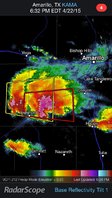
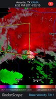
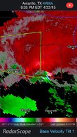
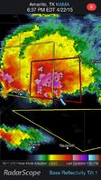
Here are a couple of radar images from the supercell east of Hereford. Nice couplet, surprised there were no tornado reports from this. I hope someone that was on it will post. I did not have a chance to look at the HRRR earlier today but this looks like it was in the exact location that Jeff said was modeled by the HRRR and NAM 4km.


In the second two images, I marked the interface of the inbound/outbound winds in the velocity image, and then switched to the reflectivity image while leaving the marking - it seems oddly displaced from the hook, even though the radar updated by two minutes when I switched... Thoughts?
 

Attachments

  • ImageUploadedByTapatalkHD1429757647.999270.jpg
    ImageUploadedByTapatalkHD1429757647.999270.jpg
    195.9 KB · Views: 169
  • ImageUploadedByTapatalkHD1429757666.348627.jpg
    ImageUploadedByTapatalkHD1429757666.348627.jpg
    207.9 KB · Views: 197
  • ImageUploadedByTapatalkHD1429757790.447035.jpg
    ImageUploadedByTapatalkHD1429757790.447035.jpg
    209.2 KB · Views: 170
  • ImageUploadedByTapatalkHD1429757802.813340.jpg
    ImageUploadedByTapatalkHD1429757802.813340.jpg
    225.4 KB · Views: 204
Here are a couple of radar images from the supercell east of Hereford. Nice couplet, surprised there were no tornado reports from this. I hope someone that was on it will post.

David Drummond was streaming live when a short lived tornado touched down on the southeast side of Hereford. Not sure about any other confirmed touchdowns, but it was definitely a beastly supercell.
 
STAFF NOTE:

Remember that posts about what you saw while chasing go in a REPORTS thread for the date rather than the EVENT thread for the date. We moved several posts in this thread that belong there. Posting pictures of the atmosphere in an EVENT thread is fine if it goes along with a discussion about the evolution of the atmosphere from a forecast or current event standpoint. However, if it's just to say, "here's what I saw. It was beautiful." then it goes in a REPORTS thread.

Thanks!
 
Is the Lockney storm (SPC tornado report around 8PM CDT, see others' pics in Reports thread) the same storm that was around Hereford at about 5:30PM CDT as shown in the radar images I posted earlier?
 
Back
Top