• While Stormtrack has discontinued its hosting of SpotterNetwork support on the forums, keep in mind that support for SpotterNetwork issues is available by emailing [email protected].

2015-04-17 EVENT: TX/OK/KS

  • Thread starter Thread starter Brett Wright
  • Start date Start date

Brett Wright

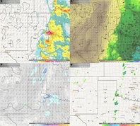
Well this is the first time I ever posted on here, but I feel that Friday is worthy of our attention in the eastern Panhandle area of Texas for a legitimate severe weather event. In my 5 years of chasing, if I am west of 35 and there is non south easterlies at 850, storms turn LP and die most of the time(just my observation), and Friday looks to keep winds @850 at about 130-140 degrees to the SE which is excellent. Good convergence along the dryline, decent instability and good shear(50+kts @500) should set the stage for isolated supercells somewhere near CDS and areas south moving NE throughout the evening. My gut says the tornado drought for many will end in these next few days with this cut off low.

One worry I have is the weaker winds below 700 and a slight veer back veer component but it really doesn't look all that bad.

Either way, good luck chasing and I really should use Stormtrack more often, seems like a amazing forum.
 

Attachments

  • 4-17-15 Forecast facebook.jpg
    4-17-15 Forecast facebook.jpg
    2.7 MB · Views: 278
Definitely think the Childress to Clinton OK area has potential per 12Z NAM. There's less of a southerly and more of a southwesterly component at 500mb which I think will be better than Thursday with more 850/500 spread. CAPE values look to be around the same (1500-2000 per NAM) as Thursday as well. Definitely has chase day written on it, and hopefully will be less attended if you will.
 
Definitely think the Childress to Clinton OK area has potential per 12Z NAM. There's less of a southerly and more of a southwesterly component at 500mb which I think will be better than Thursday with more 850/500 spread. CAPE values look to be around the same (1500-2000 per NAM) as Thursday as well. Definitely has chase day written on it, and hopefully will be less attended if you will.
I agree, I still think tomorrow may be a good chase day, but I have to write it off with lab in the evening. As for Friday, I think SPC will catch on tonight and most likely highlight the area near CDS which will get more people talking about the setup. I am exited to see what 00z says.
 
Latest NAM has pretty decent instability (2000 j/kg) nosing into E CO. Shear is pretty decent too. These kind of upper level setups seem pretty favorable for tornadoes in E CO. May 2008 Windsor rings a bell, as well as more historic events. Great dynamics overall. I too am curious to see what the 00z says as far as CAPE is concerned... hopefully the NAM stays and the others come more into line.
 
Im tempting the possibility of playing the dryline in SW Oklahoma pending school and other priorities. Today surprised me in the magnitude and general coverage area of the threat. Given that profiles tomorrow will be similar I think it warrants watching.
 
Hodographs just look ugly tomorrow. Major S-shaped hodographs, although the kink in the shape is around 500 mb, which actually makes anvil relative winds pretty good. Still, though, deep layer shear is going to be marginal again like it was Thursday (today). CAPE doesn't look to get much above 2000 if that.

Actually many of the 00Z models are predicting the TX MCS to rage on through the night and die as it approaches I-35 in OK in the mid-morning with recovery after that. I suppose it depends on how widespread that MCS coverage is, how strong/cold the cold pool it leaves behind is, when it actually dies and how much cloud cover is left remaining. If it's pretty clear by the late morning, early afternoon, things may go. Otherwise I think it will be another marginal crapfest like Thursday was. Gustnadoes for all!


00z Models are making me re-think. S shaped hodos like Jeff mentioned and a thermo profile not as nice as anticipated. Given the weak winds through the boundary layer and marginal anvil level winds if anything gets going its likely to be HP and may struggle to drop anything. Effective bulk wind difference is a pitiful 29 knots. This throws up some major alarm bells in my head for the threat of supercells. MCS and cloud cover may completely destroy the threat of anything as well. Have a lot going on and this will be a tough call. Good news is its relatively close so I can wait and get some stuff done before possibly making a poor decision to chase this.
 
Raging MCS as Jeff mentioned above still raging this morning at 9:30 approaching the OKC area with most of the state socked in clouds. It's still early, but the HRRR just blows up another line of storms behind this. The positive is good rains, the negative is it seems unlikely we'll see supercells today.

Looking at the 12Z Observed soundings and it looks to be ugly overall. I was planning to chase, but I'm having my doubts. I can't leave Norman until 1pm, so the northern play up by Goodland would be out of the question for me. With adequate clearing and the fact it'll be on the nose of the stronger 500mb flow later on today, I wouldn't be surprised to see some reports up there.
 
Like yesterday (when I didn't have time to drive to the TX panhandle to the more obvious target area) I'm once again on the fence. The central and southwest TX area is catching my eye. What I like about the setup in central/southwest TX area: in the left exit of the jet, all the impulses rippling around the cutoff low, and it is reasonable close to my home base in DFW. What I don't like: no obvious surface focus for lift (crossing my fingers for an outflow boundary, it would be ashamed to put that mid level lift to waste), all the rain this area has gotten already, and I wish the CAPE was better. My gut is the southern areas might be more interesting. My problem is I'm not enticed enough to head out early (as I don't think it will be spectacular enough to warrant the drive to the southern area most likely to produce) - yet if I wait like I did yesterday and head out southwest of Ft. Worth - it will pop and die before I get there without producing much of anything but some small hail. Thoughts?
 
Is anyone impressed with NE CO or SW KS? I'm in Pueblo, CO and am thinking of making a trip to either. Getting to the TX panhandle is out of reach for me. I like the CAPE in KS more than NE CO, but the SPC has a 5% chance over NE CO. The dew points look high enough to maybe support something north but shear in SW KS looks more favorable. I'm trying to stay within a 3-4 hour drive and having trouble deciding 1) if it's worth the trip and 2) which one would be.
 
Little OFBs keep getting spat out of this complex but it really isn't going to matter unless things start clearing out here in the next hour or so. A pretty distinct boundary just kicked out across Baylor County, TX and east but convection is still shooting off to the immediate west and further SW down the dryline. The OUN sounding wasn't particularly helpful with that MCS popping a squat over west-central Oklahoma and the main area of interest being down by the Red River. I'd hope that a more westerly component at H5 would set up with that second jet max ejecting around the center of the upper-low to offset a VBV wind profile but everything else is still looking highly conditional in terms of supercell development in the evening unless there is some heavy duty clearing down south.
 
I'm planning to head east on I-70 around noonish. Vis Sat shows dry punch advancing northward and with decent CAPE values, dews already in the low 50's, and backed surface winds in place, I would not be surprised if there is brief tornado this afternoon. Most composite reflectivity runs show a few cells firing south of the Goodland/Burlington area around 21z as well, hope that all the crapvection down to the south overnight thru this morning will not screw up the day.
 
Slightly concerned about the diffuse dryline in W KS/E CO and what moisture there is mixing out. Latest HRRR runs are getting a tad more aggressive with 50s remaining (which could be an artifact of remaining cloud cover) and subsequent higher instability. Wind profiles are definitely best in the region with consistent veering with height, especially as that LLJ starts to crank around sunset. As clouds start to break across the region, the convective temp in the upper 60s should easily be reached so I don't think initiation will be a problem. Heck, temps already near 60. The hardest part will be getting these storms to be rooted to the surface with the lack of higher moisture. Target is initially Oakley, KS and will drift west likely after that.

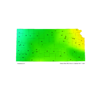
Current mesonet obs attached.

Chip
 

Attachments

  • KS_TEMP.png
    KS_TEMP.png
    183.9 KB · Views: 162
Back
Top