• While Stormtrack has discontinued its hosting of SpotterNetwork support on the forums, keep in mind that support for SpotterNetwork issues is available by emailing [email protected].

2015-04-09 REPORTS: IA/IL/MO/AR/MI/WI

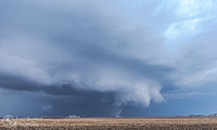
I don't have any respectable footage or photos to share. I targeted the region near the triple point in east central Iowa, where a cell fired in the early afternoon southwest of Ottumwa and struggled early on. The cell eventually developed better organization and low-level flow, going tornado warned southwest of Iowa City. I wasn't impressed with the amalgamation of the cells into an HPish mess, and given cloud cover further east, I anticipated problems with lapse rates recovering and opted not to stick with the cells proximal to the warm front as they headed towards the IL border.

I dropped south to intercept a cell southwest of Burlington, IA, but it died out shortly after going SVR warned and developing a stellar updraft, rain free base and beaver's tail. Finally, I dropped south on the cell coming out of NE MO into west central IL, and intercepted near my home community. The cell produced some marginally severe hail before dissipating as it moved northeast. I called the chase at that point due to the distance between ongoing convection and warm front across northern IL, in conjunction with the less than favorable southwesterly winds.
 
Michael, we were on the very beginnings of that Rochelle storm, it was actual two storms that merged if you look at the loop. We watched them fly away as nothing special and went after the more "classic" looking supercells approaching from Iowa, that instantly died upon entrance into IL
 
Mid-level lapse rates and some subsidence in the wake of that morning MCV really killed the hopes for anything south of I-80 today. I hung around western Illinois and played with three separate supercells, none of which looked very healthy. All were very transient, suffered from constant mergers, and never had very intense updrafts. I watched several areas of convection try to go and then fail near Jacksonville, before committing to an established supercell that I thought would surely get the job done near Quincy. Visibility was quite remarkable for this region, as I could spy a wall cloud from 30 miles away before the supercell crossed the Mississippi River. However, same old story with this one as it moved into Illinois. Several really good ground scraping wall clouds with some decent structure, before completely evaporating.

Made another play to the south on a new pair of supercells crossing the river, but storm motions made this difficult to do before sunset. I can never resist chasing early in the season, but damn do I quickly long for the day with storm motions back under 40 knots. These storms, while hauling ass, also never really got their acts together. The second you'd get excited about it actually taking on decent supercell form via radar, it'd split/merge/otherwise tank and repeat the entire process. Got a view of the wall cloud that allegedly produced a funnel cloud/brief tornado near Taylorville in Christian County IL but storm motions and the grungy rainy nature of the storm made it hard for me to get a decent view of the updraft region before dark. Given frustrations and the obvious fact that it just wasn't going to happen, I called off the chase immediately at sunset and left the storm behind.

Here are a couple shots of the Quincy IL supercell as it crossed the river.

IMG_2430 c by Andrew Pritchard, on Flickr

IMG_2440 c by Andrew Pritchard, on Flickr
 
Pretty frustrating first chase of the season. Decided to play the cold front out in Iowa, and got on the dominant storm west of Ottumwa early on. We thought we saw a brief spin up just west of Ottumwa as one of the HP RFD surges pushed in, but still not sure if it was that or just lots of dust being kicked up by the RFD itself. Either way it wasn't very impressive. Struggled to keep up with the storm as it hauled ass northeast through Iowa. By the time it neared the QC we were sort of getting bored with it, as it just didn't seem to want to get the job done. It eventually produced up by Clinton, but by that time we had already veered southeast into Moline for some Applebees action, lol. We figured the day was pretty much finished, as most of the other storms outside of our dominant sup looked pretty unmotivated. While sitting at the bar at Applebees, we start to see images show up on fb of a large tor out to the east over north-central IL. Needless to say it was a bit disheartening. Not sure if we would have had a shot at getting that far east had we not stopped, but it was definitely a lesson to never give up on a chase day, even when things are looking bleak.

Here's a pic of that suspicious looking dusty thing beneath the notch a little west of Ottumwa.
28lq99i.jpg
 
I’ve done a lot of marathon chases to Kansas but this was the first going the opposite way on what was the second day of back-to-back long distance treks. I left Andover with a target of Lyndon, IL, with an eye on catching an isolated storm near the warm front. As I made my way up I-35 near Bethany storms started firing in a broken line just to my east extending up to southern Iowa, even though a couple went severe and were in range to intercept I really didn’t have interest as parameters in that environment were weak and the CF that forced them up threatened to line them out quickly. I kept on with a plan to stay the course for Illinois and headed east on I-80 when the northern most storm separated from the others drifting NE toward I-80 and the WF. I passed right through the tornado warned area without leaving I-80, noted the grungy mess and resisted any temptation to alter my course to pursue the storm.

Making it into Illinois I observed an isolated cell developing well to my east and heading on a path that if sustained would intersect I-88, if I could catch it and if it was worthy I’d make a play otherwise I’d either alter course for a different storm or just continue from I-88 up I-39 to home. I fueled up (in Lyndon!) and as the radar presentation progressively got better and the storm motion continued to take it on a path to intersect my route I felt a sense of urgency. I quickly got back on the highway and hauled it east and came upon the business end of storm just west of Rochelle. The updraft was a broad yet sharply sculpted circulation and under it but blocked mostly from view was what appeared to be a massive tornado. I took 251 north and when the view opened up I saw a tornado which visually rivaled any tornado I’ve seen in my life. I know you can't rate a tornado by sight but I knew this was probably significant and likely to be a higher end tornado. I tracked it for a little over 5 minutes until it disappeared into the distant darkening horizon.

In retrospect I would have liked to have been on it from tornadogenesis but I’m not complaining, I was fortunate enough to make such a long distance intercept where any slight deviation from my course would have cost me missing the event entirely. Been there done that, Bowdle still agonizes me nearly 5 years later and this one would have surely hurt just as much. As a footnote this was also my first Illinois tornado and although it was less than 40 miles from home I had to drive over 630 miles to see it!

Screen grab of the tornado, my thoughts are with those that were impacted by the event.

[Broken External Image]:http://i287.photobucket.com/albums/ll155/scorpionstorm/2015-04-09/2015-04-09_Tornado 01.png
 
What a day...

Like usual on local chases I was slow/pessimistic to leave, and didn't get out to door until about 1:45. Had an initial target of Dixon, given the warm front was in the area and there was and OFB just to the north. Made it to Dixon as an initial storm was moving in. It featured a nice base/lowering for a time, but weakened as it pushed northeast. After it passed we waited in Dixon for quite a while to see how things would play out. New storms developed to our southwest and started to look interesting. We ended up heading north to make a play on one of the storms, which was now just to our west. This storm went on to be the Rockford tornadic storm. We got a view on it and a nice base/lowering while on the northwest side of Dixon. We continued to follow it north towards White Pines State Park, and then east through Oregon. East east of Oregon we witnessed two brief touchdowns to our north (storm was near RFD airport at the time). We continued to stair-step northeast with the storm, before finally dropping off of it as we sat south of I-90 and it continued northeast through Boone and McHenry counties.

At this time we headed back south to make a play on the what would become the Rochelle storm. After heading south for just a few miles on Irene Rd we got view of the tornado to our southwest. We pulled off to the side just north of Route 72, as we were in perfect position. We had a good view of the tornado for a decent amount of time, and were within about a 1/2 mile at the nearest point. This tornado probably featured the second best motion I've seen, only behind Moore '13 and ahead of Wayne 13'. ...Multiple vorticies, suction vorticies, a horizontal vortex aloft and a satellite tornado that ended up touching down in the field next to us about 1/4 mile away. We continued to jog north/east and stayed with the storm and witnessed two other brief satellite touchdowns to our north while on Glidden Rd.

Unfortunately, this fool left his camcorder on all day so the battery was dead by the time tors started happening, so I didn't get any quality video. Luckily I did get some pictures and some crappy cell phone video.

2mhd639.jpg


muh7ad.jpg


r2w55h.jpg


k2d66x.jpg


34f0heg.jpg
 
I am David and I am a beginner storm chaser from Indiana. Thursday was my very first chase and I was amped up. Had a hard time sleeping so I was up at 7am and blasted west. My initial target area before going to bed was Princeton,IL and northward. I looked at some data early on and after a call from my Meteorologist friend who navigated me via phone I decided to head toward the Quad Cities. I stopped near the Quad to check radar and call my navigator and we saw the radar beginning to look awesome in South Central Iowa so I pushed to Iowa City then south. Got into Washington and was going in for my first intercept. It had just went tornado warned and I was intense and had high hopes. The rotation was strengthening and I posted up on driveway to an old farmhouse and watched the storm for a few minutes. It was trying its best to produce a tornado and eventually did and was caught by Aaron Tobin. I blasted east to stay ahead of the storm on IA-92 to Columbus Junction then north on IA-70 to Nichols. It was HP so I kept staying east of it and got on US-61 to Muscatine where I got gas and checked the radar. My cell was tornado warned and headed toward Clinton with a tornado. I had work in the AM the next morning and I was 6 hours from home and my navigator had to get to class so I decided that I have to get back home. Biggest mistake EVER. I could have taken I-88 instead of I-80 and been there with all the other chasers who were on my storm then got to Illinois for the Rochelle-Fairdale monster. I stopped to eat shortly after and radar had tornado warned storms all over. I was looking at the monster cell to my north and knew that it was going to be a big deal. Wish I had went after it. Completely unacceptable on my part but a valuable lesson. Should have realized those storms were near the triple point. It was obvious to the big time chasers such as the Basehunters who were on my storm. Overall though I had a blast and finally pursued something I have been wanting to do for a long time. Got me more focused on getting back to school and pursuing Meteorology as well. Captured some decent photos of the storm that I was on between West Chester and Muscatine County.
043.JPG 047.JPG 048.JPG 050.JPG 053.JPG 062.JPG
 
Yeah, we were on the cell as it was developing and crossing the Missouri and Iowa border. The cell would pulse and weaken and was nothing but sloppy. After running into Skip and Jennifer, we gave up on the storm after three hours of nothingness. When the storm finally got its act together, we couldn't get ahead of it without going though the hail core. The road network and conditions were bad and not work the risk.
 
Here is my video of the development of the Rochelle tornado. Before you bash me about the quality of the video, keep in mind that I have very little chasing experience, which was compounded by the fact that I was alone, and this was my first "real" tornado. I have more videos from the rest of the chase, but this is probably the most useful one because I have yet to see another video that shows the development of this EF-4 monster.

 
This day started with me being stuck at work later than planned in the Quad Cities. I had intended to work a half day and leave around noon. Things didn't work out and I found myself running to my car at 4:30 as storms were just west of town. I ran up north to Eldridge, IA just as the storms gained their tornado warnings. I couldn't really see much as everything was very rainy and unorganized looking. I quickly decided this wasn't for me and began heading east crossing the river on I80. Being late to the game I didn't have the best synoptic awareness ever but I knew the warm front was somewhere draped across N IL. I figured I might as well head east on I88 to see if anything semi discrete could form out in front of the blob to my west and interact with the front. Going back and looking closer at things this was a good move as the front was just north of 88. This MD came out about that time which I was to busy to notice. http://www.spc.noaa.gov/products/md/md0259.html Shortly after I got pointed east I noticed a couple cells pop up south of Sterling. These had the characteristic kidney bean shape and looked promising. They merged and crossed 88 just east of Dixon where I got off 88 and picked up Hwy 38 east. Things really started looking interesting now as I was just behind the forming hook as it was moving NE. Crossed an area with some pretty significant hail on the ground just west of Franklin Grove where the core had passed moments ago. Moving into Franklin Grove the RFD cut was apparent overhead and just north of the highway. I missed the initial formation of the tornado when my view was obstructed passing thru town but as soon as I cleared the buildings the rope tornado was just off to the NE. I figured at the time that this was going to be a quick spin up so I stopped immediately to take photos. I quickly realized this was not going to be the case as it just kept getting bigger. I took off after it and did my best to keep up, which was pretty tough. I did manage to stay close enough to get some shots of it entering its wedge like stage. The motion on it at this point was by far the fastest I have ever seen. Bowdle is the only thing that even comes close and it really falls short. By this point the chase was nearing its end. Stair stepping to the NE I kept encountering the damage path making it impossible to keep up. Fortunately most structures were missed until I came to the location of a farm, restaurant, and several homes at the intersection of Hwys 64 and 251. Emergency responders were thick at this location and I figured it was time to get out of the area and let them do their thing. I went east from there and headed south on I39 for home. Here are a couple photos from the day.

IMG_6252-Edit.jpg IMG_6266-Edit.jpg
 

Attachments

  • IMG_6273-Edit.jpg
    IMG_6273-Edit.jpg
    133.4 KB · Views: 229
Nick, I enjoyed the video, nothing to bash there! You captured an historic event, can't always have the luxury of stationary tripoded video! Congrats on your first "real" tornado!

Thanks Jim! I was trying my best.

Fortunately most structures were missed until I came to the location of a farm, restaurant, and several homes at the intersection of Hwys 64 and 251. Emergency responders were thick at this location and I figured it was time to get out of the area and let them do their thing.

View attachment 7710 View attachment 7711

I also went through here not long after the tornado. I have footage of the damage (between videos 4 and 5 of my chase), but I'm not comfortable putting it online. Emergency responders hadn't been there long, and I didn't realize just how bad it was at the time. Later, when I watched my video, and also the aerial survey video, my heart sank when I realized what I drove through. It was my first time in that situation, and I don't think I made the right decision. :(
 
Last edited:
This is my first post since the site was revamped, so let me say now I have no idea how the post will manifest itself. I wasn't exactly chasing Thursday, I had actually just left a meeting in Taylorville (southeast of Springfield) to run over to McDonald's for some iced tea, when the sky to the west caught my eye. IMG_2400.JPG

I'm used to an unrestricted view of the horizon out where I live, in open, flat country and my first thought was I had to get out of town where I could see what was going on over there. I didn't have a good camera or recorder with me, but got some decent shots on an iPhone. The first is the storm heaving into view, in the next there is a distinct collar cloud and rotation is starting to become evident.
IMG_2416.JPG IMG_2434.JPG

I think another cell was starting to organize here, with inflow feeding in.IMG_2440.jpg

This next was a cool catch, considering it's from a cell phone.IMG_2468.JPG

The storm was tornado-warned at this point, with reports of a funnel cloud, although I never saw a funnel or even strong rotation myself. There was, however, a lot of funnelish-lookiong scud and tag clouds around the edges of the cell.IMG_2484.JPG

The last picture is the storm cell as it went over Taylorville, with sirens sounding for the second time. The cell phone camera was pretty well useless by now, so I was done. Several other chasers who were on the storm had already driven past me and on up the road, presumably to get back ahead of the storm or find a fresh one. I never did make it back to my meeting, but they had already pretty well figured out they wouldn't be seeing me again once the sirens went off.
IMG_2495.JPG
 
Headed to the Quad Cities area thinking EC IA would have a good shot at tornadic sups if we could get a pre-frontal storm or two. A data check upon arrival there showed many cells had already fired on the cold front in SC IA, and were heading NE at a pretty good clip. Surface winds were veering pretty badly in E IA, so I declined to go after them. Instead, I elected to wait just east of the Quad Cities, hoping for new, discrete development in the N IL warm sector, and models were predicting surface winds to eventually back some there as the approaching surface low deepened. Eventually, a couple new storms did initiate almost right over my head, and I followed them as they tracked up closer to the warm front. They struggled to get their acts together though, so I let them go, as they were about to cross the front. At that time, I noticed a raging, tornado warned HP supercell just west of the Quad Cities, I figured I might as well check it out, just in case nothing else noteworthy formed. I intercepted that storm near Clinton, IA, just as it was ramping up on radar, with a well defined hook and couplet. That storm looked like a mean, green, HP beast, and I had little doubt that it was producing a tornado. ( A damage survey has since shown that this storm did in fact produce an EF1 tornado near Clinton.)

The Clinton storm as it was producing an EF1 tornado:
011.jpg


I wanted nothing to do with a fast moving, rain wrapped tornado, so I headed back east for one last shot at discrete development in N IL. Not too much later, the soon to be Rochelle storm began to go dominant, and we all know what happened thereafter.

A couple pics of the Rochelle storm and tornado:
020.jpg
028.jpg
 
Back
Top