• While Stormtrack has discontinued its hosting of SpotterNetwork support on the forums, keep in mind that support for SpotterNetwork issues is available by emailing [email protected].

2015-04-09 EVENT: IA/IL/MO/AR/MI/WI

Chris, I am not exactly sure what killed these storms, but at least for the storm that I was chasing, it had one solid RFD surge and that is what did it in. This could have been a similar story for the other storms south of I-80. It is also possible that the system started pulling in a lot of much drier air from the southwest as it really started wrapping up? Just a very amateur guess.
 
My mom lives in NE'n side of Longview, TX. Says a large tree came into her garage last night (Thu 4/9/15) and there's widespread damage in the neighborhood. I suspected winds but she says local media is talking about a spotted tornado in NE Longview. No tornado reports on SPC page indicated in Longview (or anywhere in Texas for the 9th)
I suspected this was all wind damage and not tornado but looking at the web site for the local paper, I'm unsure now. Anybody see a tornado signature in Longview TX evening of 4/9/15?
 
Yes, the storm near Longview definitely had some rotation. At one point about 110 kt gate-to-gate shear. But I suspect it was hard to see due to trees and the storm had a lot of precip around it. Wouldn't be surprised if they find some tornado damage near Longview.
 
Yes, the storm near Longview definitely had some rotation. At one point about 110 kt gate-to-gate shear. But I suspect it was hard to see due to trees and the storm had a lot of precip around it. Wouldn't be surprised if they find some tornado damage near Longview.
Well I'm in Wichita Falls on some other business and was going to head home today but guess I need to get to mom's in Longview to help her with the damage from the tree. She's going to want to move now. This is the second tree that has damaged her home in 2 years. She's surrounded by huge trees, mostly pines and when the soil is wet, it's a tense situation when a little wind comes up.
 
My mom lives in NE'n side of Longview, TX. Says a large tree came into her garage last night (Thu 4/9/15) and there's widespread damage in the neighborhood. I suspected winds but she says local media is talking about a spotted tornado in NE Longview. No tornado reports on SPC page indicated in Longview (or anywhere in Texas for the 9th)
I suspected this was all wind damage and not tornado but looking at the web site for the local paper, I'm unsure now. Anybody see a tornado signature in Longview TX evening of 4/9/15?

The storm was tornado warned and had an impressive couplet on the NE side of Longview. At one point the local TV broadcast measured approx. 156 mph gate-to-gate couplet. That area of circulation probably lasted 30 miles but was strongest on the NE side of Longview.

There was a church and long-term care facility that sustained moderate roof damage, along with many trees down in the area. I'm not area of any photos of a tornado, it was likely rain-wrapped.
 
Damage surveys are being conducted near Longview, TX, today. NWS-SHV has a link to a PNS statement on their website. That Longview storm had good rotation and also a likely TDSS on dual-pol for a couple of scans.
 
I've created a radar animation from the supercell that spawned the large tornado in Illinois:
https://dl.dropboxusercontent.com/u/65745050/animatie_VS-Illinois_2015-04-09_0.40s.gif

The preliminary rating is EF-4:
http://forecast.weather.gov/product.php?issuedby=LOT&product=PNS&site=lot

Edit: For those interested; here's another radar animation from the HP-supercell that spawned (likely) 2 tornadoes in eastern Iowa. It passed pretty close by the KDVN radar-site, so that radar had a good view at it. The animation is an APNG however (because of quality issues), so not every browser will display it. A browser that does it in any case is Firefox. https://dl.dropboxusercontent.com/u/65745050/animatie_VS-Iowa_2015-04-09_0.50s.png
 
Last edited:
I was so wrong about yesterday. I could have also easily saw the EF-4 as that is where I would have targeted if I would have chased. I have much to learn...
 
This video is currently making the rounds on social media of a motorist coming within yards of the Rochelle tornado's core flow on I-39.

 
Ohhh man I'm going to grill that video on Sunday on my podcast. Anyone who wants to join me, send me a PM.


"I don't really know what to do, except just sit here, maybe duck down..." What an idiot. Interesting comments on YouTube, marveling at both his stupidity and how he maintained his composure - although his calm is probably the result of being completely oblivious about what is coming at him. Treats it like he's watching a dust devil approaching...
 
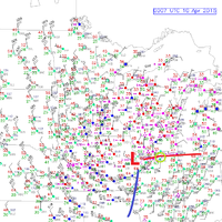
I'm actually wondering if the Ogle/McHenry County tornado might have interacted with a pre-existing OFB.

That area had been impacted by several rounds of convection throughout the day, and a 00z surface analysis showed the actual front sitting around or just north of RFD, which is about 20 miles north of the cell's initial track. It certainly was in close enough proximity to perhaps interact with streamwise vorticity from the effective warm front, but there may well have been a residual boundary interaction involved too.

I cannot really discern from the available surface maps if that is the case, because RFD is the closest official observation, but in reviewing composite reflective loops, I can't help but wonder if some sort of residual boundary(ies) came into play here too. Other factors existed as well, including sufficient instability and increasing low-level shear parameters, owed in part to a strengthening LLJ closer to 00z.

It has been kicking me since I initially was targeting the Rockford area, but decided that discrete supercell chances wold be maximized early on in E IA and WC IL before convection amalgamated into a QLCS or large squall line. I'm taking a closer look at satellite imagery to see if there is any evidence of residual boundaries too.

SFC 041010.png
 
Back
Top