• While Stormtrack has discontinued its hosting of SpotterNetwork support on the forums, keep in mind that support for SpotterNetwork issues is available by emailing [email protected].

2015-04-09 EVENT: IA/IL/MO/AR/MI/WI

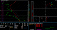
comparing the NAM, and the NAM 4km, I have been noticing a gradual speeding up of the system. However the NAM 4km looks to keep things pretty reasonable for western Illinois. I have to concur that seeing how the convection from tomorrow night is going to be the key as to if or if not I will go out.
 
Make sure you are in your target areas by 18z ready to chase!

I would totally have to agree with Adam in this situation. I'm becoming less of a fan of tomorrow's setup for tornadoes in the region, but it could be our first chance to truly get rocked by some good storms. That said, I'm not ruling out a tornado. A lot will depend on the ability for the enviro to clear tomorrow afternoon and sfc heating to be induced.

Shear profiles however, are not my favorite by a long shot.
I would almost like to see less of negative/neutral tilt in the 500mb flow, that way we could keep the winds more westerly and up the directional shear.
Again, would have to agree. The way the low is ejecting and becoming so neg tilted is almost a bad attribute for this setup. If there was more sfc heating/less overnight convection/more backing of sfc winds, I would be a huge fan, but with the way things look to be ongoing in the morning, it's hard to see things playing out just the way we want. The big wild card in this whole setup will be what happens overnight tonight and what is ongoing when we wake up tomorrow. I'm trying to talk my team into heading out early and skipping class, but we shall see if my persuasion and experience allows that to happen.
 
SPC just did new Day2.
day2probotlk_1730_any.gif


I'm eager to see 18z Nam and Nam 4km in a few hours. Still loving what 4km offers but not so much regular NAM lately. Hoping the warm sector in NW IL can destabilize after overnight activity or the are can avoid it almost altogether, as it seems like the best area near the low and south of the warm front. Also hoping the surface low offers more backed winds at the surface than advertised.

Perhaps the cold front farther north will maintain a more N/S orientation to help compensate the upper level winds appearing to back as you go up the Hodo, maybe helping keep storms discrete.
12_NAM_033_41.47,-89.76_skewt_ML.gif


This is a sounding just east of the Quad Cities at 4pm tomorrow
 
Currently looking at a rectangle target area in NW IL Coal City/Galesburg/Peoria/Princeton between about 3-7pm for best action. This was forecast using the 12z model runs, so things could definitely change and really depend on tomorrow's early convection more than anything imo.
 
12z runs seem to have sped things up just a tad especially on the GFS. This makes things a little less favorable from a quality chasing standpoint. The surface low would end up in WI by 21z as things are lining out and about to plow through IL. I think any chance for a tornado will be early on (perhaps as early as 18z) near the surface low. I would almost like to see less of negative/neutral tilt in the 500mb flow, that way we could keep the winds more westerly and up the directional shear. Things are pretty unidirectional from 850 up so its going to come down to critical surface backing which we will only have very early on in the setup.

Tonights convection is going to play a huge role in how things play out tomorrow.

A) We don't need that junk sticking around too long killing off the instability until its too late. If this were to occur we would just end with a sloppy linear complex spawned by last minute recovery and cold frontal forcing.

B) WAA storms seem a good bet. I would love to see the advancing boundary get re-enforced but that seems like a pipe dream with an ejecting system such as this. In fact, now that I've typed that out it doesnt even make sense. Still, anyway it can slow down will certainly up the chances for a good tornado. I don't like seeing that WF lifting into C WI by 0z. Right now I am banking near the surface low or east along the warm front early on. Make sure you are in your target areas by 18z ready to chase!

Adam, looks like you could've inserted your quote from yesterday in here today as the NAM hasn't changed much in the last 24 hours, IMO.

1.PNG

Dropping the Fort Madison sounding/hodo in here to concur with what @chrisbray said earlier. Looks like a late morning/early afternoon show based on soundings downstream as it looks to go linear really fast as that CF gets to the Mississippi.

Target: As of now my play will be somewhere just east of the surface low at it approaches the Quad Cities. Of course, that may change in the next 8 hours.
 
If it were completely up to me, I would be heading into IA as well, getting a very early start, however, I have others to consider and they do not want to go to IA.
Unfortunately for me, I am meeting my partner in Joliet at noon and we wont get to quad cities till 2. He has limited time off until June and didn't want to spend more than a half day off on this setup.

My hope is that either cells or line segments can a) push out ahead of the boundary somewhat or b) reform or sustain themselves as they get pushed into Eastern IL from 2-4pm, where parameters seem to be maximized
 
Current thinking prior using 12z 4km NAM/NAM product runs
 

Attachments

  • Map of IL.gif
    Map of IL.gif
    130.1 KB · Views: 382
Big differences in the 12 and 4km NAM for tomorrow. If the 12km NAM plays out... I don't want to talk about that. There are major problems with heavy, widespread ongoing convection, unidirectional winds, low orientation/progression and sfc temps to name a few.

If the 4km NAM plays out, I'm in. Although I like the solution the 18z run has with a major ofb from convection, the clearing in the warm sector in the 0z run is great imo. Will allow for good amount of sfc heating and therefore higher tht-e/cape values in that region. With this solution, I would love to head out early to IA and hit the first round of storms and follow the cf/dl into nrn IL, but it seems as if the group of people I will be with are plit and due to obligations won't be able to get to IA in time for the early show. Therefore, I am torn between playing the wf, the cf/dl play and the warm sector.

With the wf, ingredients for rotating storms seem quite good and more likely, however, storms may become elevated it winds don't back quickly and end up in a congealed line of elevated mess in an area much less than perfect and heading into congested milwaukee/chicago area/the WI hills.

The cf play has more unidirectional shear vectors and the chance of being undercut by an early season cf with fast storm motions, yet cells seem to stay nicely discrete and if they can stay sfc based/ahead of the cf may be able to gain enough spin to become briefly tornadic.

The warm sector play is the wild card to me. I like the way clearing allows sfc heating to initiate cells in the 21-23z range in an area that is highly chaseable. With the storms staying discrete and without the need for a major lifting mechanism, storms will likely be able to moderate the enviro around them to allow and draw in more favorable air allowing helicity to increase and lowing to occur. Atm, this would likely be the route that I took if I had to decide where to go according to the 4km NAM, that being said, it will greatly depend on how the overnight convection plays out. Analysis bright and early tomorrow morning, then we will see where to go from there.
 
Looking at tonight's model runs, I am seeing quite a bit of disagreement. NAM and GFS are quite a bit slower than the RAP, and also the GFS is showing less instability than the other two models. Winds are more unidirectional than I would prefer, but there is decent speed shear, and directional shear could still be decent right on the warm front east of the triple point. The question is where to start out. If the NAM is right, maybe Cedar Rapids, but if the faster forecast of the RAP is right, somewhere in northwest IL like Freeport might be better. One positive is that, so far, at least, there does not seem to be much convection going on near or southwest of the target area, as much of the earlier activity has fizzled out. If new convection does not fire and move into the target area, contamination from overnight convection might be less than feared. Two things to keep in mind - northwest IL and also northeast IA once you are north of 20 - increasingly so as you get closer to the Mississippi River - are not the best chase terrain, being rather hilly and wooded. Also, there are limited places to cross the Mississippi River, so if you start in IA, be sure you know where the crossings are and plan accordingly.

On the NAM and RAP, there are also some decent parameters farther south, but a concern there is that the surging cold front will force a fast-moving, linear storm mode. Certainly could be some QLCS tornadoes, but chasing them, if they do occur, will not be easy. The chance for discrete storms appears better farther north, near the warm front just east of the triple point, where ever that ends up being.

Obviously this setup is way too far east for me to chase, but having grown up in IA and lived most of my adult life in IL I find it interesting and will definitely be cyberchasing.
 
Thinking we're going to be targeting the Iowa City/Waterloo/Ottumwa Iowa triangle based on the latest guidance. High-res models have continued to indicate a slightly slower evolution of the cold front/SLP, and the new 12km NAM looks a bit slower as well. HRRR, RAP, and others indicate pretty respectable levels of cape in the 2000-3000j/kg range already by noon. Storms look to kick off by 20-21z from Waterloo down towards Ottumwa. Respectable shear vectors relative to the cold front, vorticity advection, and decent low-level shear should yield a broken band of supercells that could become tornadic in short order given the environment. These storms are going to be hauling ass, so it's going to be a challenge to keep up with them. Might be best to stay about a county ahead of the developing storms and wait to pick out a dominant one. Should be a fun little chase. Good luck to all who head out.
 
Despite the new outlook, which pretty much whiffs eastern IA with the tornado threat, I respectfully disagree and stand by the target further west towards Iowa City, etc. Slower timing of the front has been consistent now on several runs of various guidance. Morning convective shenanigans could throw a wrench into things, but unless that happens I still favor the Iowa side over Illinois. At least initially.
 
Up early looking at models now, before any soundings are available. I like what the Nam4km and RAP are throwing at us, not so much HRRR and NAM.

I will be keeping a close eye on the warm advection early morning crap to see how much cloud cover lingers. I hate that about chasing the Midwest, it is almost always dependent on overnight crap, or rather its absence, in order to destabilize. I do like how the RAP keeps the wind fields more backed at the surface today as the low swings through, hopefully that is realized.
 
I will say that we are debating not going now. My friend doesn't like the 5% only from SPC, though I have argued that 5% days can and do produce good tornados. Seems like there is just so much uncertainty in regards to where destabilization will occur.
 
I remain partially optimistic for something in my favorite state today, but glad SPC dropped down a notch as it was getting some of the TV weathercasters a little too hyped up (one said "first outbreak of the year", another breathlessly commented that he lost sleep last night hitting refresh on the DY1 outlook page :( 
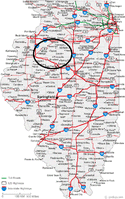
). The warm front continues its trek northward, setting up north of Lansing tonight. HRRR has plenty of pretty winds aloft. All this happened during the day I'd be highly enthusiastic - at night in April is still a reasonable chase hope.
 

Attachments

  • hrrr.PNG
    hrrr.PNG
    250.4 KB · Views: 165
Looking at this mornings model runs, I do have to admit that the pinch point in MO and IL between the shortwave trough and the ridge looks exciting, but I wish their was some directional shear. Sure, their is a lot of speed shear, but maybe too much. Given that I'm in north central Texas, and my schedule will not allow me to drive that far, I'm going to wait it out here. Besides this is the first chance of the year for us in DFW to get some lift from a cold front when we have other conditions right for severe weather, and I wouldn't want to miss something in my own back yard. I'm tired of the dryline bust this year in Texas. I'm tempted to go northeast towards Texarkana, but I'm afraid if we get something it may line out before it gets that far. The models are in wild disagreement about how fast the front is going to move on the Texas end, so I going to wait it out. I may still end up driving northeast from DFW if the front moves faster.
 
Back
Top