• While Stormtrack has discontinued its hosting of SpotterNetwork support on the forums, keep in mind that support for SpotterNetwork issues is available by emailing [email protected].

2015-04-08 REPORTS: KS/OK/MO

My first ever southern plains chase. Long story short, I started the day on the northern storms and lost interest very fast when I saw the first storm I was on race north and die. I looked down the dryline on radar and saw some interesting stuff. I raced south and got on the supercell that eventually died by Seiling. It looked pretty awesome when I first arrived, but after about 10 minutes it was obvious it was not going to make it. Overall, I had a blast finally getting down to Kansas and Oklahoma. I learned a few things...It costs money to drive on I35. Kansas mud is horrible, I almost ended that chase early by getting stuck. There is no dollar menu at McDonalds. The terrain is awesome and gorgeous but some areas I saw in NW OK were quite difficult, so it's not just flat fields everywhere like I imagined. I still have much to learn... Overall though, I love it down there and can't wait to come back.
full

full
 
Courtney and I left for the Wellington area at 1030 from the Lawrence/Kansas City area. We sat in the Walmart parking lot there for what seems like ages and watched two storms go up to our east, one by Arkansas City the other by Eureka. Both of those storms looked decent visually but radar told us the truth in that they were not the show. With it getting close to 1800 we decided that the only play of the day for us was going to be the storms coming out of Oklahoma into Comanche and Barber counties. A few minutes before hitting Medicine Lodge, the storm went tornado warned. Just as we got out of town on the west side on US 160 we ran into some decent sized chunks of hail. Data was non-existent at that point but it didn't matter, we knew we had to punch that core, or rather, let the storm core us and move on to the northeast.

We did just that and as the hail stopped, the meso to the SW came into view. We came to a "scenic view" resting stop and setup shop there with about 20 other chasers. By the time we had stopped and got out, we caught the final moments of the tornado as well as the following cone funnel. That funnel soon dissipated and we were treated to decently rotating meso for about the next 20ish minutes before it moved NE, became higher based, and eventually petered-out. As we moved NE behind it, we sampled some more golf balls and some pretty crazy hail fog coming off the fields. By this time, it was dark and we were watching the storm NW of Wichita get going as we had data back. We ended up being a little further away from that storm than we realized so we just drove straight to Wichita, refueled the car and ourselves and called it a day. Interesting day, underwhelming for sure, but it was a nice first chase of the year!

The first screen is the cone funnel looking SW from about 5ish miles west of Medicine Lodge. The second is just simply a wider view of the meso as a whole.

4915.jpg 49151.jpg
 
My chase team and I headed north on 35 from Norman at 1pm to catch possible early initiation. When the CU field started to build in far western OK we immeditaley headed that way. We headed to the triple point where conditions we most favorable. We tracked the storm that put down a few tornadoes for about 3 hours. We saw the first small cone it put down and the next rope it put down. Unfortunately, we were behind some plateaus when the large cone was on the ground, so we could only see the wall cloud and the very top of the large cone. By the time we got to Medicine Ridge the nado had lifted. Here are some pics:

2qmkklf.jpg


v5jvnp.jpg


takaqv.jpg


2jdi2id.jpg


P.S. That was my first tornado!

P.S.S Not sure if I like the close-up structure pic or tornado more o_O
 
We originally targeted Wellington Kansas thinking the DL would be just West as the day unfolded we saw the changes and headed further West. Out of Hardner we took the wet dirt roads and got in position to watch the cell develop. It started to rotate and so signs we would hit the jackpot. After seeing the first two tornadoes we went further North along Aetna Road and saw the cone and rainbow. We encountered golf ball sized hail once we hit 160 highway and had to stop for a bit while the rain and circulation crossed 160. The only damage we saw were a few pine trees snapped on the South side of 160. With the cell dying we hauled to Goddard but got there too late.
 

Attachments

  • 1.jpg
    1.jpg
    66.6 KB · Views: 244
  • 2.jpg
    2.jpg
    75.9 KB · Views: 216
  • 3.jpg
    3.jpg
    146.8 KB · Views: 232
  • 4.jpg
    4.jpg
    236.5 KB · Views: 240
  • 5.jpg
    5.jpg
    194.8 KB · Views: 232
It was a good and bad day for me.

I'll start with the good.

I'm not 100% certain, but I think I possibly seen the tornado that Skip posted in the original post... from much further away.

View attachment 7588

I was SW of Medicine Lodge (just north of Hardtner) at the time it was taken... right at 6:54 pm. I'm not sure if I can call this my first official tornado or not since I can't clearly see it on the ground. Either way, I was pretty pumped at the time.

And now for the bad.

I realized today just how far away I am from being as good of a chaser as I want to be.

I can't forecast whatsoever.
I just can't drive my car close enough (due to worries of hail damage).
My photography skills need a lot work.
The cone rainbow was on the ground at 6:55 so you must may have seen it. Congrats!
 
We decided to target the southern dryline storm near Camargo, OK instead of the triple point storm. Initially it really looked like it would be the storm of the day with a healthy meso and storm top divergence values of up to 140 knots. It definitely had a ridiculously strong updraft. I do hate that we missed tornadoes, but this LP supercell had probably some of the most photogenic and ridiculous structure I've ever seen. It produced a number of funnel clouds and wall clouds but it just couldn't quite do it. I believe if it could have stayed strong for an hour longer, we would have seen a tornado with the better wind fields moving.

I do not regret going after this storm instead of the triple point. The structure of the meso was almost better than an HP tornado IMO. Not to mention, for most of the time we felt like we were all by ourselves watching on great roads and great terrain. We picked a storm, stuck with it, saw it at its strongest, and were very happy. My only regret is that it didn't last very long. It moved east into the cooler temperatures and slightly worked over atmosphere and just could not compete with the cap. All in all... a fun day. Not quite like we hoped but we definitely didn't come home empty handed.

11149499_10100254358939952_9147950233496095151_n.jpg


10985869_10100254358949932_5107389099296162017_n.jpg
 
Like many others, I dumped the triple point storm in Kansas for the dry line storm over Western Oklahoma. I felt as though the mode looked fairly messy to the north and figured storms moving off the dry line would offer better photo and tornado ops than the one to the north. Pretty much go to the storm and it was completely gone, fizzled away. I would have gone after the north storm had I known the southern storm would fizzle as fast as it did. Such is chasing though. You make the right decision sometimes and others you make the wrong decision. This would be day 1/2 of doing such for myself. Rough start to 2015.
 
First chase of the year for me. I was a little late for the tornado on the Barber county storm. Did see the cone shaped lowering/funnel thing after that. Not sure on that. And found some near tennis ball size hail.
 

Attachments

  • 4-08-15 hail.JPG
    4-08-15 hail.JPG
    76.6 KB · Views: 141
Good day all,

I was chasing out in Kansas on April 8, 2015, and was on the storms (and tornado) to the southwest and west of Medicine lodge, Kansas. The FULL log for this chase is also below at the link provided (also includes subsequent chase in Illinois on April 9)...

http://www.sky-chaser.com/mwcl2015.htm#APR7

Below is the details on the Medicine Lodge, Kansas storm on April 8, 2015...

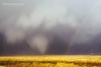
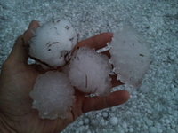
April 8, 6:00 PM - Interception and indirect penetration of an extremely severe and tornadic thunderstorm in Barber County, Kansas from west of Medicine Lodge, and north and east towards Nashville, Kansas near Highways 160 and 42. The storm was a classic (and cyclic) supercell thunderstorm. Two tornadoes were observed with this storm, one being a brief low contrast elephant trunk, and another one being a large tornado that lasted about 5 minutes. Fortunately these tornadoes occurred in open rural terrain. The storm had a striking visual appearance, with a striated updraft and multiple layers (like an upside down wedding cake). The storm also produced winds gusting near 50 MPH, and baseball sized hail. Hail to at least 2.5 inches, albeit melted, was observed west of Nashville, Kansas behind the storm as it was weakening. Heavy rains and frequent lightning (with some close hits) was also observed. Hail damage was observed near Nashville. Conditions causing the storms were a warm front / dryline interaction, surface heating, vertical wind shear, a low pressure system, and strong upper trough. Documentation was digital stills, HD video, and audio. A 2009 Ford Escape was used to chase the storms. A tornado watch was also valid for the area until 12 AM CDT the next day.

Below are pictures from the chase day (April 8, 2015)...

m16chv1.jpg


ABOVE: My chase vehicle (2009 Ford Escape) with hail protection in place and ready to start chasing in Kansas (April 8, 2015).

m16wc1.jpg


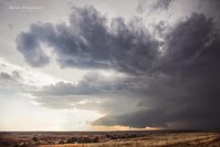
ABOVE: Wall cloud on the Medicine Lodge supercell storm in Kansas on April 8, 2015.

m16tor1.jpg


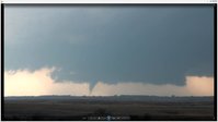
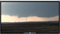
ABOVE: Brief wedge tornado to the southwest of Medicine Lodge, Kansas on April 8, 2015.

m16hail1.jpg


ABOVE: Large hail, partially melted (tennis to baseball sized) near Nashville, Kansas on the evening of April 8, 2015.

m16hail3.jpg


ABOVE: Hail covering roadway near Nashville, Kansas on the evening of April 8, 2015. Note the hail fog forming.

Below is a chase map for this trip (April 7-9) which includes this chase...

m16cmap1.jpg
 
20150408_T3_1_wm.jpg

From an initial target of Arkansas City, KS I shot west when storms began to fire on the triple point near Cherokee, OK. After much debate north of Alva, OK I decided I could not get out in front of the dryline cell and decided to go north to the Medicine Lodge, KS cell. It was tough finding a turnout on 160 west of ML but I finally did and got this video grab of the main tornado that day.
 
Of course I would have to follow @Skip Talbot and @Jenn Brindley's absolutely stunning photos :)

Got a late jump west like lots of others. It didn't help that we tried to hedge in case of eastern development, so we got on the Medicine Lodge storm quite a few minutes after it was TOR warned. At first I couldn't understand why the hoard of SN dots wasn't crashing in on the hook, but then I remembered the Barber County road network. Instead of testing our luck on the winding dirt roads, we instead sat just south of Medicine Lodge for most of an hour as the storm closed in and got timelapse. We followed northeast out of town for only a short while before calling it a chase and heading to Woodward for the night.

 
Last edited:
Back
Top