• While Stormtrack has discontinued its hosting of SpotterNetwork support on the forums, keep in mind that support for SpotterNetwork issues is available by emailing [email protected].

2013-05-26 REPORTS: NE

cdcollura

EF5
Joined
Jun 12, 2004
Messages
1,436
Location
Sunrise, Florida
Good day all,

With tornado possibilities on tap for today (5/26) in Nebraska, a supercell near Broken Bow (Custer county), Nebraska was observed producing near baseball sized hail and incredible structure instead. Very dramatic storm indeed!

m14init4.jpg


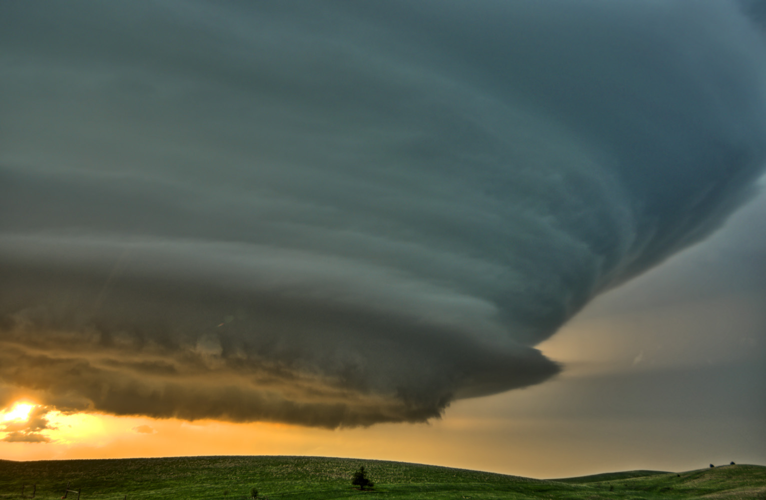
Above: Developing LP supercell in Custer County, Nebraska on May 26, 2013. The view is to the SE. Massive upward motion on this storm.

m14hail4.jpg


Above: Big hail from under the meso NE of Broken Bow, NE and southeast of Comstock.

m14lp5.jpg


Above: Leading edge (SE) side of supercell.

m14lp6.jpg


Above: Eastern side of supercell and vault region (loaded with baseball sized hail at the time) ... Creeping over the Plains of the Central USA!

m14lsc1.jpg


Above: Lightning illuminates weakening supercell looking NE after dark.

m14lp4.jpg


Above: Wide angle view of supercell when it was near Broken Bow, Nebraska.
 
Last edited by a moderator:
After waiting for a couple of hours just north of North Platte near the intersection of NE 97 and US 83, I also chased the beautiful, sculpted LP supercell that fired over rural Custer County between Lexington and Broken Bow. A few pictures follow.

I took this shot from NE 92 between Arnold and Merna. I was still well north of the growing cell, so the view here is to the southeast.

jNWerNV.jpg


I then headed east through Broken Bow and out NE 70 to Westerville. I took the next two pictures near Westerville on NE 70. By this point the updraft was literally towering over me and spitting out the occasional one to two-inch hailstone:

PldGpsI.jpg


wcrt3JC.jpg


I then moved further west on NE 70 between Westerville and Arcadia watching the storm - which eventually became TOR-warned - move very slowly off to the northeast. I took the last shot just west of Arcadia. This was one of the most visually arresting storms that I've ever seen.

IsVv266.jpg


lYffzkz.jpg
 
Some pics from the 26th in Nebraska. Took our time to get onto it and missed it's earlier stages but still probably one of the coolest storms I've ever had the pleasure to photograph! Enjoy!

IMG_5258.jpg


IMG_5456.jpg


IMG_5502.jpg


IMG_6022.jpg


IMG_6057.jpg


IMG_6109.jpg


IMG_6127.jpg


IMG_6148.jpg
 
Last edited by a moderator:
Superb shots above from all !

This was one of my favourite chases over there as I pretty much done everything on instinct and what I was seeing (no GRL2 or equivalent in car ).

The attached video is two parts. The first is a timelapse of the Brewster supercell. On review the cell fell apart through ingesting cold air at low levels ( that's my theory anyway). The second part is some of the magnificent lightning as seen in the posts above, my pics a little more humble and I was trying to do video and pics at same time.

I strongly recommend viewing the video at HD on YouTube. I also tend to narrate a bit and do a build up sequence - like showing the first storm initiation. Search my channel for other May 2013 chases.

Watch video >


(click for larger)

This was one of my favorite chases of the year. It was great to meet Christopher out on the road in person, who posted above. I actually had flown into Denver, met my customers around noon. We traveled east with no expectations, so this was a great surprise! Didn't have a tripod though because I didn't feel like taking it with me on the flight, so I have some miss givings thinking about what I could have taken with my camera had I had my tripod. Overall great day!

 
I was sitting near Litchfield, NE in the late afternoon waiting for initiation and very confused by what the sky was doing and began to despair that anything was going to pop. Felt guilty over tasks I should be doing at home (an hour away) and so went back to Kearney to get some supplies at the local Menards. When I came out of the store there was an Atom Bomb to my NW. Checking Radarscope on my iPad i was amazed to see only the hint of a return on radar. Then I realized that it was exactly midway between LBF and UEX's radar sites and, due to the curvature of the earth had to get very tall to even register. I took off an intercepted my first LP supercell SW of Ansley (not far from where I had been awaiting initiation a bit earlier. DOH). Enjoyed following its leisurely pace until dark. I got this image east of the berg of Westerville, Nebraska.


Custer County Supercell by ~Pixelsmithy, on Flickr
 
Back
Top