2010-12-31 DISC: AR, IL, LA, MO, MS

Information on 3-tornadoes in Central MS. Ratings of EF-0, EF-2, and EF-3.
NWS Jackson, MS.

http://www.srh.noaa.gov/jan/?n=2011_01_01_severeweatherevent


While driving back from seeing two bolts of lightning and a rainbow in E AR...I remember looking at that storm and associated couplet that came near Jackson, MS and thinking to myself.... "that is no doubt the most impressive thing I have seen all day." Sounds like NWS folks got a good scare. Seeing a storm with that sort of radar presentation and couplet is more than enough to get a person excited.
 
19 tornadoes confirmed by damage surveys in MO and IL

NWS St. Louis County Warning Area:

8 Confirmed tornadoes:

1 EF3 tornado (Sunset Hills, in St. Louis County, MO)
1 EF2 tornado (Robertsville, in Franklin County, MO)
2 EF1 tornadoes (City of St. Louis, and Ballwin in St. Louis County, MO)
4 EF0 tornadoes (Augusta, in St. Charles County, MO; Washington, in Franklin County, MO; Greenville, in Bond County, IL; and Cedar Hill, in Jefferson County, MO)

http://www.crh.noaa.gov/sgf/?n=event_2010dec31_summary


Springfield, MO County Warning Area:

8 Confirmed tornadoes:

2 EF3 tornadoes (Ft. Leonard Wood, in Pulaski County, MO; Rolla in Phelps County, MO, 2 fatalities)
2 EF1 tornadoes (Lecoma, in Dent County, MO, 2 fatalities; rural Christian and Weber Counties, MO)
4 EF0 tornadoes (all near Table Rock Lake in Stone County; 2 occurred between 11:30 p.m. on 12/30 and 12:30 a.m. on 12/31; the other two around 8:00 a.m. on 12/31)

http://www.crh.noaa.gov/sgf/?n=event_2010dec31_survey


Lincoln, IL County Warning Area:

1 Confirmed tornado:

1 EF3 tornado (Petersburg, in Menard County, IL)

http://www.crh.noaa.gov/news/display_cmsstory.php?wfo=ilx&storyid=61897&source=0


Paducah, KY County Warning Area:

2 Confirmed tornadoes:

2 EF2 tornadoes (Ellsinore, in Carter County, MO; Poplar Bluff, in Butler County, MO)

Note: Damage surveys are still under way in some areas, and additional information may still be forthcoming.
 
Tulsa, OK County Warning Area:

1 Confirmed tornado:

Cincinnati Tornado (Adair County OK, Washington County AR, Benton County AR)

Began: Near Westville, OK in Adair County OK at about 6:05 AM CST 12/31/2010

Ended: 3 miles northwest of Tontitown, AR in Washington County AR at about 6:27 AM CST

Path Lenth: 21 miles

Max Path Width: about 500 yards

EF Rating: EF3 with maximum estimated winds of about 140 mph. This EF rating is primarily based on severe damage to 3 permanent homes and a destroyed metal (volunteer fire department) building system in Cincinnati.

http://www.srh.noaa.gov/tsa/?n=weather_event_30dec2010
 
6 tornadoes confirmed in Mississippi:

2 EF0s (Warren County: Vicksburg; Kemper County: Gholson)
1 EF1 (Oktibbeha County: Starkville)
2 EF2s (Hinds/Rankin Counties: southeast Jackson metro; Attala County: Durant to Ethel)
1 EF3 (Noxubee County: Macon)

Three of these tornadoes were at least 1/2 mile wide, but the Jackson office seemed rather arbitrary in their sizing.

http://www.srh.noaa.gov/jan/?n=2011_01_01_severeweatherevent
 
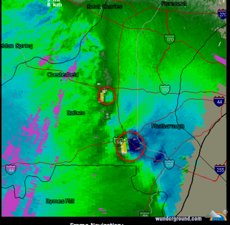
I wanted to post a couple of images from Friday's St. Louis-area tornadoes. The first is the STL TDWR at approximately 11:50 am. The -88D "hiccuped" and there was missing velocity on the azimuth of Fenton-Sunset Hills tornado. Fortunately, the TDWR showed it and the smaller Balwin tornado (farther north) very well.
Picture+67.png


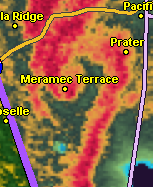
The second image is of the same storm when it was farther southwest and producing the damaging tornado near Robertson, MO. Those of you who have read Warnings may recall my description of a November tornado echo that looked like a "candy cane." Here is a similar echo:

Picture+69.png


Given the lack of conventional hooks, it would have been very difficult to warn of these tornadoes in the pre-Doppler era. There is no doubt the warnings saved many lives Friday and we in the meteorological profession should be very proud of our contribution.
 
KMOX Radio Tonight to Talk About the Storms

I have been invited to be on the "John Carney Show" on 1120 KMOX (www.kmox.com for streaming) at 10:30 CST tonight. We'll be talking about the tornado swarm that hit the St. Louis area and about Warnings: The True Story of How Science Tamed the Weather.
 
Based on a previous Case Study done by Jon Davies, I went back through to some RUC soundings and found some interesting features from the NYE Outbreak.

164863_728438616315_30406759_39215973_6875013_n.jpg


An indicator that tornadoes and significant tornadoes may be likely in a high shear/low cape environment is the location of the CAPE. The lower in the sounding the highest CAPE is located, the better for tornadic supercell development. (In an otherwise favorably sheared environment of course.) Several of the soundings from Dec 31 exhibited that feature.

You can read more here on the soundings and a wrap up of the full event here: http://convectiveaddiction.com/2011/01/03/suprise-new-years-eve-tornado-outbreak-case-study/
 
Ryan, that's a great observation and I totally agree with you. I don't know the location for that sounding, but when this event was pending I noticed a couple different NAM reads for 3 km MLCAPE of 75 J/kg in Missouri. One run placed a sort of bullseye northwest of St. Louis, and a later run depicted a narrow strip extending through central MO out of Arkansas. (I ran a RAOB sounding that I wish I had saved, which showed a nice, fat low-level CAPE profile.) I believe there was an even higher value down in LA or AR. The two central MO storms, including the Rolla EF3, coincided with that strip, which presumably moved east and provided the necessary low-level energy.

I think 3 km MLCAPE is a valuable tool for winter and cold core setups; I believe that's something I got out of Davies' article when I read it (it's been a while), and NYE certainly bears it out. I've also been paying attention to normalized CAPE as an overall indicator of parcel acceleration, and suppose that by its definition it would apply to low-topped storms as well as to typical, higher-topped convection.

All that being said, some of the storms the other day went tornadic in environments that had some pretty skinny, stretched-out CAPE. But maybe there was something I missed; I just remember being surprised when I looked at some soundings.
 
Last edited by a moderator:
Another elderly individual died today after being injured in the Cincinnati AR tornado. That raises the death total there to 4 and overall 8 in both Arkansas and Missouri.
 
One of the tornadoes in Attala County Mississippi was upgraded to an EF3 per NWS in Jackson. THat would bring the total outbreak to 7 EF3's.
 
This past week I put together a short presentation for ILX with regard to the Petersburg IL event of this day and something I observed that I believe may have contributed to the intensity of it. They concur with the possibility so I figured I'd share it with you. I had been watching convection through the overnight including a cell to come into the area around sunrise that I knew would have an elongated arcus cloud trailing with it. I took off from Decatur towards Lincoln IL to view this cloud after work and though no photos for traveling with the inability to stop, it was as I expected, pretty cool looking and especially for the golden light filtering down through. Besides that, I also noted backing at the surface as well as considerable rising motion on the leading edge. This boundary would slow down to the point of stalling as it drifted SE. I would travel E with it on State RT 10 for a little while, outrunning it before US 51 and head home only to go back out again for the big show a short while later. Hindsight being what it is, I wish I would have gotten more images and video of the activity I witnessed because it draped from Logan county SW into Menard county. Cells training up from the SW would earn warning but only one went nuts. Radar review in correlation to where I understood this boundary to be visually put most of the cells on the cold side with the Petersburg cell bisecting at ground zero. The area of most significant damage was of course very limited and it would seem to me that a supercell crossing a surface boundary in that area is to blame as evident by the path length. Referencing IEM radar saves superimposed with a line where I believe this boundary hung, I would be curious anyone's thoughts regarding the animation found below. My meteorology has never been very good (sorry) but identifying surface boundaries is an aspect to capture my interest for some time now and this was a great opportunity for doing so.

WMV 11.7MB
http://pawleewurx.com/123110.wmv
 
Last edited by a moderator:
I recall the night before it was very warm in the STL area. I had gone to my grandparents house Thursday night and came back late that night/early Fri. morning and wore just a t-shirt and jeans because it was in the mid-upper 60's. All the action was off to the west over central MO slowly inching east. Fast forward to dawn, I'm letting out my parents dogs (I was dogsitting) and I heard the thunder/felt the wind. I wanted to chase locally, but due to it being NYE, I had to go into work early. It was a NYE I will never forget.
 
Back
Top