• A friendly and periodic reminder of the rules we use for fostering high SNR and quality conversation and interaction at Stormtrack: Forum rules

    P.S. - Nothing specific happened to prompt this message! No one is in trouble, there are no flame wars in effect, nor any inappropriate conversation ongoing. This is being posted sitewide as a casual refresher.

2010-12-31 DISC: AR, IL, LA, MO, MS

Joined
Dec 6, 2009
Messages
195
Location
Rockville, MD
The tornado that hit Cincinnati, AR (Washington county near the OK border) has 3 confirmed deaths associated with it. Not a good day.

http://www.nwaonline.com/news/2010/dec/31/tornado-reported-northeast-washington-county/?breaking

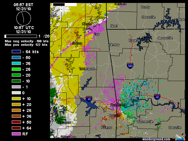
Here's a SRM grab from the cell (the northern, most obvious couplet):

20101231_AR_SRM.gif


---
EDIT: Got a little excited and posted in the wrong forum. Thanks mods for the move.
 
Last edited by a moderator:
Tornado hit Westville Ok did significant damage, just northeast it entered Arkansas and in Cincinnati Arkansas reporting 3 fatalitiesl Tad late on this report...............
 
Significant damage reported in Rolla, with houses destroyed from the northern of two supercells in central Missouri. Additionally a tornado touched down at Fort Leonard Wood, also from the same storm.
 
Tornado fatalities on New Years Eve. I don't recall ever hearing of this before and wonder if any of you have.
A chaser (Tim Piotrosky?) said that the tornado was rain wrapped and not visible at all, but warnings did preceed the storm. At 6:00am, most people were probably still snoozing unfortunately.
 
Here is the observed morning sounding for Springfield, MO. Lots of shear but a surprisingly decent amount of instability. 900 joules of MLCAPE at 12z on Dec 31st is impressive. Looking at this sounding, it's not surprising there were at least a couple significant tornadoes. The sounding from Little Rock was very similar to this one:
SGF.gif
 
I just watched a segment on TWC in which Dr. Forbes was giving a radar analysis of the situation near St. Louis when he was abruptly cut off by a commercial. Nice to see TWC cares about the welfare of viewers.
 
There is pretty significant damage more or less paralleling I-44 from Fenton MO to the Crestwood Shopping Center in the SW St. Louis area.
 
Getting this from my friends girlfriend who is talking to her folks around Fenton, MO into the Sunset Hills, MO. Church roofs gone, two story house's now into one story, roofs gone, garages blown in or gone...says you can actually see where the tornado went.
 
Here is a radar velocity image from around the time of the Sunset Hills, MO tornado:

vel123110-1158am.jpg


Note the strong couplet just southeast of the intersection of I-270 and I-44. (For those of you unfamiliar with the STL area, about midway between the two hail markers). Always scary to see a radar signature like that in a densely-populated area.
 
They've confirmed one fatality near Rolla in Phelps county. Preliminary calls are from straight line winds, although it's possible it was from the tornado reported just minutes before in that area. Numerous tornado reports in the St. Louis area.
 
Just an FYI to those sharing photos "from near Belleville, IL" and others. The fields and trees are actually NOT a lush green color in Illinois during late December.

I'm nearly 100% sure that the Tim Brookshire image from Belleville is June 9 2005 near Hill City, KS.
 
TDWR radar shot of the STL tor as it was between Fenton and Sunset Hills. Also one of KLSX radar as it was right over Sunset.
 
Tornadoes have been reported on Dec 31, back in:
1971, 1973, 1975, 1978, 1984, 1986, 1992, 2002 and 2006.
1950-2009 Data.

States: *1971 HI *1973 AL,GA, *1975 FL,NC *1978 TN
*1984 TX *1986 FL *1996 TX *2002 FL,MS *2006 GA

Today has set a record for the number of tornadoes for
this date of Dec 31.

Researched by Mike Geukes
 
Listening to the radio and sounds like people are trapped in their car and poles are down. Also watching a live stream and looks like things are in the road blocking the highway.
 
Not trapped in his car, he took shelter in an area where power lines came down. He had to drive over the curb to get out.
 
1156 AM TORNADO SUNSET HILLS 38.54N 90.42W
12/31/2010 ST. LOUIS MO NWS EMPLOYEE

A PRELIMINARY EVALUATION OF STORM DAMAGE IN THE SUNSET
HILLS AREA HAS CONFIRMED THE DAMAGE WAS DUE TO A
TORNADO. THE NWS AT THIS TIME HAS DETERMINED THE DAMAGE
AS POTENTIALLY GREATER THAN EF3. A MORE DETAILED SURVEY
OF THE DAMAGE WILL BE COMPLETED ON SATURDAY MORNING TO
MAKE A FINAL EF SCALE RATING.
 
Back
Top