Jason Toft
I thought I would make a thread on this subject.

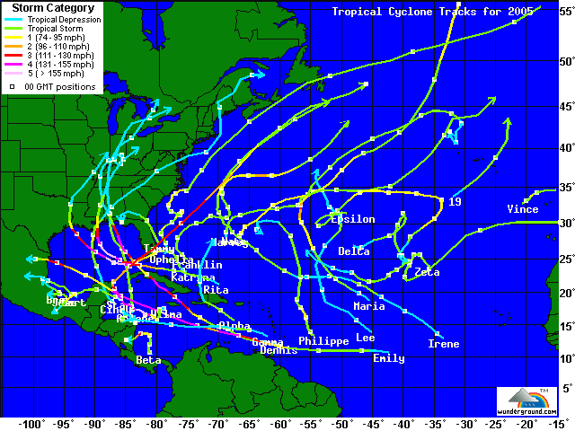
This season has been absolutely amazing, from a meteorological perspective. We had two storms form in June, a climotologically quiet month. Both were tropical storms, Arlene going into the FL/AL border, Bret going into southern Mexico.
Cindy was the first storm to form in July, and it took a northerly track towards Louisiana, clipping NO. Then we had two Major (CAT 3+) Hurricanes form, Dennis and Emily. Dennis hit the same area as Arlene, just from a different angle. Emily took a course WNW and only affected Mexico with it's strongest winds, but extreme Southern Texas was also affected. T.S. Franklin formed, then took an erratic track, never affecting the US. T.S. Gert then formed and closed out July by affecting the same area as Emily.
T.S. Harvey formed out in the middle of the Atlantic and affected Bermuda before racing NE and dissipating. Hurricane Irene then formed and looked like it might have affected the east coast before turning out to sea. T.S. Jose formed in the Bay of Campeche (sp?) and, during it's short spell, managed to dump heavy rains in southern Mexico.
Then came Katrina.

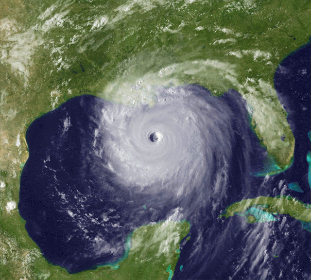
This intense and highly destructive storm formed from a lingering tropical wave and possibly the remants of Tropical Depression 10, which formed and dissipated about 9 days earlier. It made a brief landfall north of Miami, took a southwest turn, then essentially took a westerly course, then a big right hand turn took it straight into LA, a course that meteorologists and scientists in general had been predicting and dreading for decades.
T.S. Lee formed in the middle of the open oceand and never affected land. Hurricane Maria also never affected land, while Hurricane Nate skimmed south of Bermuda, just giving them a windy day.
Hurricane Ophelia was a strange system. It changed from a hurricane to a tropical storm and back THREE times and skimmed Cape Canaveral/KSC, amd dumped heavy rains and strong winds over the Eastern North Carolina coast. Hurricane Phillipe meandered around in the same area as Lee and never affected land, being sucked up into a large frontal system.
Then came Rita. As the second Category FIVE storm of the season, we set another record, with there being only three years where this has happened, '60, '61, and '05. Rita looked to be another Galveston, TX, storm for a while, and caused a huge evacuation of that area. She also set a record for the 3rd lowest pressure of all time in the Atlantic, bumping Katrina from it's spot there along with kicking '92's Andrew off the top 5 entirely, at 897mb (26.48" of Mercury). That closed off the month of September.
The first storm of October was Hurricane Stan, being prompt as all men are, and forming on the first. He took a track over the Yucatan and into southern Mexico, dumping up to 25 inches of rain in places that didn't need it. His death toll in total has been approximately 1500, because of the many mudslides and flooding that he caused. T.S. Tammy formed off of the east coast of FL, taking a mainly northwest track and making landfall at the FL/GA border.
Hurricane Vince...wow. He formed in an extremely rare spot off of a stalled low pressure system that gained tropical characteristics. His small size (no more than 75 miles across) was very peculiar, and before he dissapated, Tropical Depression Vince set a record as the first tropical system to make landfall on the Iberian Penisula and in Spain.
T.D. 24 was just upgraded to our last name on the list, Tropical Storm Wilma. The current computer models have the storm heading north, possibly affecting my area, the west coast of FL, as a hurricane. We will see if that happens what the rest of the story holds.
With six weeks left in the season, it is very likely that we will get our one November storm, in which we would move to the Greek alphabet, starting with Alpha. This would make 2005 the most active hurricane season EVER.
Jason Toft
October 17, 2005
Images © Weather Underground, www.wunderground.com
Text © Jason Toft, 2005

This season has been absolutely amazing, from a meteorological perspective. We had two storms form in June, a climotologically quiet month. Both were tropical storms, Arlene going into the FL/AL border, Bret going into southern Mexico.
Cindy was the first storm to form in July, and it took a northerly track towards Louisiana, clipping NO. Then we had two Major (CAT 3+) Hurricanes form, Dennis and Emily. Dennis hit the same area as Arlene, just from a different angle. Emily took a course WNW and only affected Mexico with it's strongest winds, but extreme Southern Texas was also affected. T.S. Franklin formed, then took an erratic track, never affecting the US. T.S. Gert then formed and closed out July by affecting the same area as Emily.
T.S. Harvey formed out in the middle of the Atlantic and affected Bermuda before racing NE and dissipating. Hurricane Irene then formed and looked like it might have affected the east coast before turning out to sea. T.S. Jose formed in the Bay of Campeche (sp?) and, during it's short spell, managed to dump heavy rains in southern Mexico.
Then came Katrina.

This intense and highly destructive storm formed from a lingering tropical wave and possibly the remants of Tropical Depression 10, which formed and dissipated about 9 days earlier. It made a brief landfall north of Miami, took a southwest turn, then essentially took a westerly course, then a big right hand turn took it straight into LA, a course that meteorologists and scientists in general had been predicting and dreading for decades.
T.S. Lee formed in the middle of the open oceand and never affected land. Hurricane Maria also never affected land, while Hurricane Nate skimmed south of Bermuda, just giving them a windy day.
Hurricane Ophelia was a strange system. It changed from a hurricane to a tropical storm and back THREE times and skimmed Cape Canaveral/KSC, amd dumped heavy rains and strong winds over the Eastern North Carolina coast. Hurricane Phillipe meandered around in the same area as Lee and never affected land, being sucked up into a large frontal system.
Then came Rita. As the second Category FIVE storm of the season, we set another record, with there being only three years where this has happened, '60, '61, and '05. Rita looked to be another Galveston, TX, storm for a while, and caused a huge evacuation of that area. She also set a record for the 3rd lowest pressure of all time in the Atlantic, bumping Katrina from it's spot there along with kicking '92's Andrew off the top 5 entirely, at 897mb (26.48" of Mercury). That closed off the month of September.
The first storm of October was Hurricane Stan, being prompt as all men are, and forming on the first. He took a track over the Yucatan and into southern Mexico, dumping up to 25 inches of rain in places that didn't need it. His death toll in total has been approximately 1500, because of the many mudslides and flooding that he caused. T.S. Tammy formed off of the east coast of FL, taking a mainly northwest track and making landfall at the FL/GA border.
Hurricane Vince...wow. He formed in an extremely rare spot off of a stalled low pressure system that gained tropical characteristics. His small size (no more than 75 miles across) was very peculiar, and before he dissapated, Tropical Depression Vince set a record as the first tropical system to make landfall on the Iberian Penisula and in Spain.
T.D. 24 was just upgraded to our last name on the list, Tropical Storm Wilma. The current computer models have the storm heading north, possibly affecting my area, the west coast of FL, as a hurricane. We will see if that happens what the rest of the story holds.
With six weeks left in the season, it is very likely that we will get our one November storm, in which we would move to the Greek alphabet, starting with Alpha. This would make 2005 the most active hurricane season EVER.
Jason Toft
October 17, 2005
Images © Weather Underground, www.wunderground.com
Text © Jason Toft, 2005
