• After witnessing the continued decrease of involvement in the SpotterNetwork staff in serving SN members with troubleshooting issues recently, I have unilaterally decided to terminate the relationship between SpotterNetwork's support and Stormtrack. I have witnessed multiple users unable to receive support weeks after initiating help threads on the forum. I find this lack of response from SpotterNetwork officials disappointing and a failure to hold up their end of the agreement that was made years ago, before I took over management of this site. In my opinion, having Stormtrack users sit and wait for so long to receive help on SpotterNetwork issues on the Stormtrack forums reflects poorly not only on SpotterNetwork, but on Stormtrack and (by association) me as well. Since the issue has not been satisfactorily addressed, I no longer wish for the Stormtrack forum to be associated with SpotterNetwork.

    I apologize to those who continue to have issues with the service and continue to see their issues left unaddressed. Please understand that the connection between ST and SN was put in place long before I had any say over it. But now that I am the "captain of this ship," it is within my right (nay, duty) to make adjustments as I see necessary. Ending this relationship is such an adjustment.

    For those who continue to need help, I recommend navigating a web browswer to SpotterNetwork's About page, and seeking the individuals listed on that page for all further inquiries about SpotterNetwork.

    From this moment forward, the SpotterNetwork sub-forum has been hidden/deleted and there will be no assurance that any SpotterNetwork issues brought up in any of Stormtrack's other sub-forums will be addressed. Do not rely on Stormtrack for help with SpotterNetwork issues.

    Sincerely, Jeff D.

2003-05-04 KS/MO/OK outbreak

Joined
Dec 21, 2007
Messages
538
Location
Springfield, Missouri
Girard/Franklin KS, Stockton/Pierce City MO: sorry mods for not posting this in the name of the thread

Most of us remember this deadly tornadic outbreak, many tornadoes affecting well populated areas and in some cases entire towns taking direct hits. T
This event has long raised questions for me regarding the fast pace and movement of the dryline. Below I have pasted the surface plots/Tds for 21z, interestingly enough the dryline at 21z was just east of ICT and was moving east FAST!
I was chasing with Randy Hicks on this day and remember hearing (via NOAA radio) that the dryline was moving east at 40-50mph at one point.
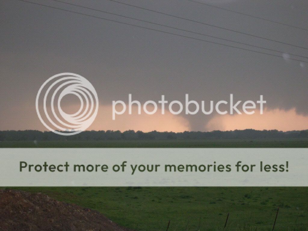
I do not ever remember a dryline moving this fast before and have always wondered why this happend. Also attached is a video grab from my cam of the Girard KS F-4. This killer tornado was a very long track tornado that we first intercepted north of Parsons KS.
Any ideas?
 

Attachments

  • 5-4-03 surface 21z.jpg
    5-4-03 surface 21z.jpg
    27.5 KB · Views: 754
  • DSC00645[1].jpg
    DSC00645[1].jpg
    11.4 KB · Views: 661
Last edited by a moderator:
This is the day that that really sparked my interest in tornadoes. I watched the KC F4 tornado live on television. Too bad I had to work for it would have been a real treat to chase that tornado. The Girard/Franklin Kansas tornado also is a very interesting. For some reason I get this gut feeling this tornado was an F5 even though it was rated high-end F4. It also produced some of the most amazing ground scouring I have ever seen.
 
I remember that day well. I was even thinking about going out as it was on a day off and had some spare cash. I planned on staging at the Kansas Speedway and let the storms come in. If I would have I would have been right on that tornado near Kansas City. :( Just could not get everything together for that day. It was, however the first storm that I was able to forecast a good chase area with so it at least made me feel good about that.
 
It is hard to believe that it will have been 6 years since the May 4th outbreak, just last year when I did the Symposium for the 5th year anniversary I commented then how hard it was to believe how long it had been since that day. I remember it as if it happened just yesterday.

Frankin and Girard are both just 7 miles from my house, my sister-in-laws parents lost their house in the tornado and a couple of friends of mine were hit by the tornado as well. I targeted closer to the dryline earlier in the day and started out north of Cherryvale where I got into Golfball size hail. I saw a weak rope tornado north of Parsons but then got caught by road construction and had to detour around to get back down to the highway. By the time I got back down to Highway 400 the storm was way ahead of me. I never saw the wedge tornado that hit Franklin despite it being 7 miles north of where I live. Though something that big knowing what it was doing and knowing that people I know were being affected by it, I’m not sure I would have wanted to see it.

I know Doug Cramer mentioned they saw evidence of F5 damage, but overall the majority of the damage was F4 which is why they went with the F4 rating.

Since my sister-in-law’s parents lived in Franklin, we had access to get into Franklin that day and the days after so I have tons of pictures I took of the damage.
 
As Joey said, it is hard to believe it's been almost 6 years since that outbreak. We intercepted the F3 tornado that went near Baxter Springs, Kansas (Cherokee County) and into SW Missouri. We got a fairly late start chasing that day but we were able to intercept the tornado as it was on the ground. This is probably equal in size to Quinter #1 as being the largest tornadoes we have scene.
Cherokeetornado3.jpg
http://www.youtube.com/watch?v=_p9RlJMqHyo&feature=player_embedded
 
I know Doug Cramer mentioned they saw evidence of F5 damage, but overall the majority of the damage was F4 which is why they went with the F4 rating.

God has it been 6 years already? I knew that Cramer and others including a few of the Texas Tech team mentioned possible F-5 damage including the area just southwest of Girard. This was the area where Randy and I had total ground scouring (no vegetation left) and this is also near where a house was completly destroyed (with only the foundation left) and the debris thrown into the pond/lake about 400 yards away.
I remember stopping to try and find a payphone to do some phoners with KTUL and TWC and to sell video (I did not have a cell phone or any data...oh the good old days!) I remember passing the area mentioned above and that's when the true reality of what just happened hit me.

The most interesting meteorological aspect to me was how quick the dryline was moving east....we have had set ups that looked almost identical to that event from 500mb down to 925 but I have personally not seen a dryline move as fast as that one did to date.
I know there was a good punch nearing 700mb and I do remember classic loaded soundings throughout the region with massive amounts of helecity but I still can not understand why it was moving so fast.....

A day that I will never forget thats for sure!
 
I know Doug Cramer mentioned they saw evidence of F5 damage, but overall the majority of the damage was F4 which is why they went with the F4 rating.

F-scale ratings are given based on the highest damage point found, not the average. I'm very curious why they rated this tornado based on "average" damage; if all tornadoes were rated using this method, there wouldn't be any F5 tornadoes.
 
Yeah, I thought if even one home receives F5/EF5 damage and the rest is F0/EF0-F4/EF4 then the tornado will get an F5/EF5 even though it was just one home.
 
I got suckered into heading for the first Red Box that stretched across NE-NC KS and SE-SC NE, instead of heading to TOP and KC. I was rewarded by lots of hail from high-based storms and a running commentary from KC radio stations as I watched the towers way off on the eastern horizon. Kicked myself for days afterward.
 
F-scale ratings are given based on the highest damage point found, not the average. I'm very curious why they rated this tornado based on "average" damage; if all tornadoes were rated using this method, there wouldn't be any F5 tornadoes.

Not sure, I always thought it was based on the highest damage point found as you mentioned but I never was sure on that. I know on at least two occassions Cramer had mentioned the F4 rating being based on overall damage and talked about that some last year when we did the severe weather symposium in Franklin and in fact I think I have audio recording from another presentation he did on it stating the same.
 
If you read many of Dr. Fujiata's descriptions of the Fujita scale and subsequent information from the SPC, they use the word "typical" damage, and not average or highest. Perhaps that accounts for why the Girard tornado was given an F4.
 
I was in Pierce City, MO a couple of hours after it struck. I'm a paramedic and was invited to come help with triage. It turned out that I wasn't needed, but I still welcomed the opportunity because it was my first experience witnessing the aftermath of a tornado. (Since then, I've worked or otherwise been in quite a few, but this was my first).

One of the first sights I witnessed was a large boat lying in the middle of the street, partially blocking the road. I also saw a balcony ripped off a duplex, lying a short distance away. In itself, that wasn't so spectacular, but what struck me was that the plastic patio furniture was still standing upright on the deck. How is that even possible? I also saw and photographed a wooden 2x4 plank impaled through a concrete wall.

None of this is unique of course, but considering it was my first encounter with a tornado's damage, it left quite a first impression on me, and was a big reason why I became fascinated with meteorology and storm chasing.

As for Stockton, I basically grew up there during my teen years. I'm still amazed when I look at the level 2 data in GR2AE. The radar images are impressive, and (like Pierce City) the town took a direct hit.
 
If you read many of Dr. Fujiata's descriptions of the Fujita scale and subsequent information from the SPC, they use the word "typical" damage, and not average or highest. Perhaps that accounts for why the Girard tornado was given an F4.

I know it's just minor detail, but more accurately it is the Franklin tornado. The tornado passed south of Girard leaving Girard untouched. Franklin which is east, slightly northeast was completely leveled by the tornado.
 
I chased this event with Justin Teague and Dave Crowley. We intercepted a cell along the OK/KS border and followed it east. As we neared Neosho, MO we witnessed an interesting cell merger as a left split from a storm to the south made a mad dash north and merged with our storm as it crossed into MO. We had to stop in Neosho for gas and a restroom stop. As we waited we could see a nice wall cloud quickly take shape just to our east. We never caught up to the storm and made it to Pierce City just 20 minutes after the tornado hit. This was a dissapointing chase, and I learned a valuable lesson about positioning well east of a dryline on days like this.
 
Back
Top