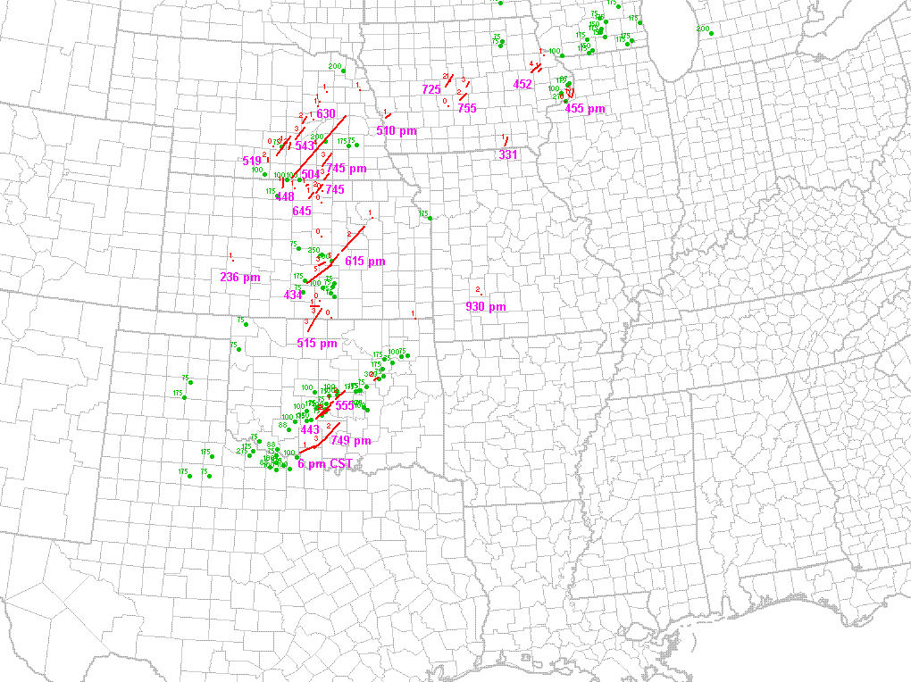
• A friendly and periodic reminder of the rules we use for fostering high SNR and quality conversation and interaction at Stormtrack: Forum rules

    P.S. - Nothing specific happened to prompt this message! No one is in trouble, there are no flame wars in effect, nor any inappropriate conversation ongoing. This is being posted sitewide as a casual refresher.

1990-03-13: Hesston Kansas tornado outbreak

Wow, amazing videos of the Webster/Nuckolls co. F4 Ryan... I hadn't seen those before. That tor definitely falls in the far bottom part of the sfc T/Td distribution for a very long-tracked violent tornado, with about 66/59F (at best) in its inflow environment. The rash of sig tors in the EAR-GRI corridor had even lower T/Td than that. Remarkable.
 
March 13, 1990 is a day that I'll never forget. A bunch of us neighbor kids were out roaming around the neighborhood trying to find the biggest hailstone we could find after the hail stopped when we noticed the wall cloud and funnel approaching from the southwest. None of us had seen anything like that before so we all scattered back into our houses. The funnel passed just to our west (was living in Silvis Illinois at the time), and ended up touching down a few miles to the north. It then went on to do F3 damage in Cordova, or about 15 miles north of the QC.

Man would I kill to see some radar images from this day!
 
I saw the last 3 tornadoes from that storm, including the wedge ne of Hesston from 13 miles away! I left Topeka a little after 4:00, when the tornado had been on the ground for over 45 minutes, and the last tornado touched down around 6:15. I have still photos, but no video. I will also never forget that day.
 
Yeah that is amazing how several strong tornadoes and even a couple of violent tornadoes came out of temperatures being only in the mid to upper 60s and dewpoints in the mid to upper 50s. Like you guys said one of these violent F4 tornadoes tracked for like 131 miles. Correct me if Im wrong but didnt the Windsor, Colorado wedge EF3 come out of a pretty low temp/dew env as well as the Murfreesboro EF4 tornado. Temps and dews seemed pretty similar to the ones on 3-13-90.
 
March 13, 1990 is by far one of them days that I wish I could have chased. Shame I was only 10! lol. Looking at the Severeplot map of March 13 and April 26 it's amazing how similar the outbreaks are.
 
For the record, the book that Lanny refers to is "Year of the Storms - The Dextructive Kansas Weather of 1990"; the editor is Howard Inglish, and it was published in Hillsboro, KS by Hearth Publishing.
 
This video was just posted on liveleak claiming to be new footage from the hesston f5

http://www.liveleak.com/view?i=ac1_1271801843

Never seen that footage before but it definitely looks like Hesston by the color of the tornado and the look of the video footage. The first part looks like a little different angle on the two tornadoes the produced the long damage path. Looks legit to me.
 
I remember the NSSFC (what is now the SPC) categorized the day as a moderate risk that morning. The conditions might have supported this, but certainly the outcome warranted a high risk.
 
I remember there was a beautiful postcard made of this tornado. We had it posted on our refrigerator for a whole year, surmising it was surely the biggest and baddest tornado in Kansas history....until Andover came along a year later.
 
If anyone has any information on the damage path of both of these tornadoes, I'd love to see it. Especially when it comes to Goessel. There isn't much information in the literature about it. After seeing Twister, watch the classic Hesston video solidified my love of tornadoes.
 
Warm front event for Iowa on this date. An F4 tornado hit Worthington in the Eastern part of the state. There was very good video from the Mississippi river area in which the home of the person taking the video was heavily damaged. At one point he shoots video looking almost straight up into the updraft itself. He takes cover as trees snap and debris begins to fall from the sky.

I rememberer the one that hit Ankeny. I was living in Southern MN but at night was able to pull in WHO radio out of Des Moines and as an avid HS BAsketball fan of any state I was listening top the coverage of the night session of the Iowa Boys Basketball Tournament and the Anken storm kit during the coverage of the night games so they interrupted that and went to storm coverage.
 
Hi, been a few years since I posted here. I remember this day, I grew up in West Central Iowa was 14 years old went fishing with Dad, I remember it being very humid, we left mid afternoon and the NWS issued a PDS tornado watch.. that evening around 5pm the strorms started rolling through and my Dad came running in after being out in his truck checking on our farm.. on the way back he was blown halway across the road by a funnel cloud and I immediately went to the window and sure enough could see it... that was my 2nd tornado. I also remember the next day a nasty ice storm came through.
 
One thing that stands out to me about videos of this outbreak is how massive the rain-free bases of the supercells were. It is noticeable in images of the Hesston storm but even more pronounced on the Nebraska storms, the tornadoes appeared to be out by themselves miles from the core.
 
Back
Top