08/17/05 REPORTS: Central Plains

Joined
Dec 8, 2003
Messages
2,208
Location
Kansas City, Missouri
Went after the Nemaha Co., KS storm today as it was returing a very nice radar signature for a while, up to 70-74 dbz. As I approached, the storm had a very nice, crisp updraft tower. Intercepted west of Centralia as the storm began to weaken and move off to the southeast - watched as the inflow choked off and separated from the storm base. The storm remained fairly high-based for the most part, but was still a lot of fun for this late in the year. Also noticed lots of Pileus formations today around the CU tops. (PHOTOS = updraft/inflow, weakening inflow, Pileus)

81705WEB2.jpg
81705WEB3.jpg
81705web12.jpg


Met up with Scott Currens and his father-in-law here and had a nice time shooting the breeze as I grabbed shots of a picturesque, low-angled rainbow under the updraft base. Scott seems like a great guy and I really enjoyed some chaser conversation. He lives close-by now, so we'll hopefully continue to run into each other under the storms. (PHOTOS = rainbow)

81705WEB4.jpg
81705WEB5.jpg


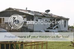
Then went east to Hiawatha where I decided to return to the path of the June 4th tornado for the first time since it happened. One farm is rebuilding now ... in fact lots of construction workers there today working on the basement of a new house to replace one that was hit. The scrap yard up the road is still in shambles pretty much, with cars still overturned and the house damaged beyond repair. Stopped and talked with one of the DJs at the radio station beside the damage path for a bit. (PHOTOS = barn from Dave Ewoldt's video, construction on new house, old storm damage)

81705WEB6.jpg
81705WEB7.jpg
81705WEB9.jpg


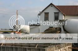
(PHOTOS = Taken in same spot as my current avatar, with new power pole to replace the one that was damaged; damaged house).

81705web10.jpg
81705WEB8.jpg


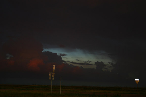
Then continued further east where a couple of nice little LP updrafts were trying to get started. (PHOTOS = LP updraft and Crepuscular rays near sunset)

81705web11.jpg
81705web13.jpg
 
Little to choose from given I didn't get out of work until 5:30! Decided to go towards Wellington, KS and take a look at things there. I was eyeing the Kingman storm and found a small Isolated cell south of there in the Anthony/Harper area. West on US 60 it was. I was watching the cloud bases to the south side of the cell and saw what very well could have been a well defined wall cloud. Unfortunately, the cell was 30 miles distant and the sun was in my face and US 160 was taking me north of the storm.

Since I wasn't about to get on the Mud Roads of South Central Kansas, I continued to cross the north section of the cell in Anvil rain until I could get south of the storm at Harper. As I was driving into Anthony, I could tell the storms passage. Bar ditches were topped out and water running so fast that a kayaker would be drooling. Excellent updraft on the western side of the cell. This was building very rapidly. Turned back east at Anthony on Ks Hiway 44. Once I got out of town and got a good look at the storm, it was starting to die out rapidly. The updraft had been undercut by the cold air from the massive amounts of rain in the very localized area. If the storm had been moving east a bit faster, it might have sttod a chance, but the cold outflow robbed the storm and it fell apart in about 20 minutes.

No tornado, No hail, a little bit of lightning. A very small but intense Supercell that spent a fair amount of time as a SVR warned Storm.
 
I captured this shelf about 35 miles northeast of Jamestown, ND around 5pm. A 200 mile trip split three ways for $7 a head. Not bad with a pool. The storm moved relatively slow allowing us watch for a while, drive east then watch again, and again. Not anything exceptional but something to report. -JT

jamestown.jpg
 
:roll: too much driving , targeted Thedford NE area first then Broken Bow to North Platte area, nothing better then seeing Jack" in the sandhills north of thedford, pretty much thought a bust, even despite the weak CU field , nothing could get going. as time went by i saw a cell pop up around North Platte, i was still in thedford, so i hauled down 83 South, to play catch up, it was an ok decent SVR warned storm, i encountered pea sized hail and some wind, cold cold air aloft, so after that passing , i sat around and figured id watch the cell right behind, i was very suprised that the 2 thunder storms got into some fuel and both went supercellish the first storm near Lexington NE, was a pretty decent looking SP ;-), then following that storm the one from behind it was getting dark, just blew up and this thing was awsome looking, pretty mean to , it was tornado warned as i was headed back home... noted a wall cloud and some roatation, a few funnels but no touchdowns, and wall clouds dissapated within 10 minutes , prb because the heat was gone sun went down, anyways sounds like a bunch of mumblish sorry i apologize..

more pics can be found at www.stormchaserdan.com

spresize.jpg


DSC01185.jpg


TIME TO DO IT ALL OVER AGAIN TOMMOROW but thankfully close to home ;-)
 
I left on Wednesday with an initial target of St. John Kansas. I was accompanied by Steve Miller(Tulsa), Joseph Tyree, Mike Gauldin and his girlfriend Jennifer. We were without data or XM, and it was great! I love getting back to my chasing roots. We intercepted the storm shortly after it formed and watched the first wall cloud form and get blasted by the RFD. The lightning with this storm was UNBELIEVABLE! We were almost struck twice. The first strike was within 30 feet and left us in shock(no pun intended). By the second close strike, we were numb from head to toe and weren't affected in the same way that we were the first time. I shot video until I was pretty sure that this storm wasn't going to produce. We went south to Cunningham to get gas and ran into Nick Benson. From there we moved back to the east, a little further from the meso so that I could take some digital photos of the storms structure.


Wallcloud1.jpg


MesoLightning.jpg


I decided to wait around until dark and try my luck with the lightning. I got 7 good shots, but these 2 were the best of the night.


Lightning3.jpg


Lightning4.jpg
 
My wife and I encountered the southern portion of the same line of storms as we were travelling across the Texas Panhandle. The rainbow and, a little later, the storms illuminated by the setting sun warranted a slight change/delay in our travel plans as we proceeded east from Amarillo. Here are a few shots I was able to get:

tx081705-1.jpg

Rainbow east of Amarillo

tx081705-2.jpg

Updraft of storm that caused minor flooding south of Amarillo

tx081705-3.jpg

Anvils illuminated by setting sun (with the famous leaning water tower)

tx081705-4.jpg

Sunset with anvil overhead

tx081705-5.jpg

Alpenglow on updrafts, with anvil rain

Note: All photos copyright 2005 by John E. Farley
 
Back
Top