06/09/05 REPORTS: Central Plains

Status
Not open for further replies.
Wow what a day. Stewart Manning and I observed atleast 8 tornadoes in Western KS. No sleep for me tonight as I just got back home and am heading out west again. Will post pics later but here is a preview picture of two tornadoes. For people in the NE KS/ Kansas City area. Video will be shown on WIBW 13 in Topeka and KMBC channel 9 in KC.

DSCF1686.jpg
 
June 9, 2005 - Kansas Tornado Outbreak

jun905tor1c.jpg

jun905tor1d.jpg


Not much time for a detailed summary. Eric Nguyen and I observed 8 tornadoes with two supercells across Kansas. The highlight included a long-lived strong tornado southwest of Hill City, KS. The tornado became a wedge and was observed from close range. The wedge contained an amazing roar and the video is awesome! Other tornadoes were noted with this supercell including two at the same time. We then observed another supercell with more tornadoes near Ellis, KS by evening.

More photos are currently on my site and additional photos will be included soon.

Scott Blair
http://www.targetarea.net/

UPDATE:

I’m certainly behind updating my chase accounts and photos from the season. However, I’ve completed the summary from June 9, 2005. This features the incredible Hill City, Kansas tornado intercept. I hope to finish updating several other chases in the near future. Enjoy!

http://www.targetarea.net/jun905.html

Scott Blair
http://www.targetarea.net/
 
Intercepted the storm in Trego County, Kansas, and watched it produce three tornadoes. A needle touched down near Trego Center at 6:00 pm, then a second tornado touched down at 6:04 pm:

6-9-05j.jpg


A cone developed a few minutes later, but from my position to the east, it was mostly obscured by rain. However, I had a good view as it moved south of Ogallah and began to dissipate.

6-9-05p.jpg


Here are the photos, beginning with the early stage of the storm as it moved into Trego County:

http://www.kickbully.com/2005Storm/6-9-05.html
 
Dickens County Tornado, Wallclouds, Funnels

Went out with David Douglas a chase friend from Austin. We got a late start cause David had to wait to get off of work. Went north quickly through Abilene, Aspermont, to north of Spur and caught the incredible ongoing night supercell in Dickens county. This storm had oodles of violent forked lighting. We got out in front of the area of rotation for awhile as large wallclouds approached. Brilliant lightning was hitting nearby so we backed off closer to the town of Spur where we stayed for a couple of hours monitoring the storm and taking pictures. I had a little trouble getting my camera set up right for nightime shooting plus I was afraid I was about to get struck - so a bit distracted. David shot some phenomenal storm / lightning pictures. One looks like a shot from the movie Independence Day where the mothership is destroying the building in downtown Washington DC. May post it in a bit.

After a while the town of Spur set off their tornado sirens and we were seeing Threatnet shear markers of 138mph as very dark and wide wallclouds / funnels approached. Some of these appeared very close to the ground in the distance and one of them may have been the logged storm north of Dickens. Eventually this part of the storm weakened and moved to the east. After awhile as the storm was moving away I suddenly noticed rotation and a debris swirl to our NNE under the edge of the base. We were amazed to see a landspout with mostly a clear funnel attached to cloud base above with small condensation fingers! I turned on the dashcam, and we both shot pictures with our digital cameras. Mine didn't turn out so great. You can tell a little from Davids.

For a last minute late night catch it was an excellent chase!
IMG_2355.jpg

"INDEPENDENCE DAY!" by David Douglas
 
Started the day in Ogallala, NE. Everything shifted to KS in the outlooks. So we targeted Oberlin, KS based on outflow boundaries and surface obs and some of the RUC (Weather Model) guidance’s. Dan, Nick, and I went to Pizza Hut just before storms started to initiate. We then got a quick data update and headed a few miles west out of Oberlin to observe a developing Supercell. We then saw a very dominate Supercell develop near Oakley, KS. We then decided that this was going to be the player of the day. We headed south on 83 to 23 that led to Hoxie and east on 24. We saw a wall cloud develop and a few nice funnels try to reach the ground, as we were looking SE. Dan decided to try and take a dirt road. Never ever do that after it had just rained there. We went two miles and we drove on what seemed to be a topsoil based road sprinkled with sand. There was a car ahead of us that fish tailed and stopped moving. We passed them and we asked if they were stuck. If we stopped we would of gotten stuck to. We almost did so we turned around and passed them again. We tried to tell them we would call some one for them. I don’t know if they heard us or if they even got out. So I called 911 and gave them there location, 2 miles SW of Tasco. We then began our route east again. Dan didn’t want to punch the core, that is the reason we headed down the dirt road. But just before we punched we saw a tornado form SE of us, and lost sight of it. I was watching radar as we dodged 1-3 inch hail stones and drove 9 more miles to Hill City. As we entered Hill City we saw a large mass to our south. I heard Scott Blair on the radio and asked him what was south of us. Then the power went out, and i heard him say a large wedge tornado was headed our way. So needless to say we drove fast. I could just make out the edges of the monster and didn't really show up on video. So after that we got held up on the way to Stockton for 15 minutes by construction. We urged them to let all of us through and told them to take shelter as a large tornado and very dangerous storm was coming our way. Just then a new Meso/ Wall Cloud formed to our south west and gained a funnel. Finally they let us through. As we got a few miles down the road I call out tornado on the ground though my camera was not on. It was fully condensed thin tornado on the ground for a brief moment. We then head to Stockton and Head south on 183. We get about 5 miles south and we stop and observe one tornado occlude as another one formed to the right of it and moved north. There was 2 tornadoes on the ground at the same time. After the elephant trunk tornado dissipated we turned north to watch a truncated cone turn into a stove pipe tornado, to a large cone tornado. The contrast was poor on this one but very excellent to witness. No damage to my knowledge was done by this. We then head to a storm south of ours and witness two more Tornadoes. We ended the day at Hay KS, with Amos Magliocco, Scott Blair, Eric Nyguen, Steve Miller, Dan Robinson, and Nick Grillo. A day that will never forget.


J9_01.JPG


J9_06.JPG


J9_09.JPG


J9_005.JPG


J9_007.JPG


J9_009.JPG


J9_0002.JPG


Full account http://midwetchasers.com
 
Floss DeHart and I first went after the meso that went north from near Oakley KS. I soon didn't like the looks of it, though (and the fact that it had storms SE of it), so turned around and headed for Hill City.

We approached cautiously as the Graham cty storm refused to get out of our way, and sporadically saw the tornado S of Hill City through rain shafts, but finally got frustrated and broke off that chase to pursue convection to the south.

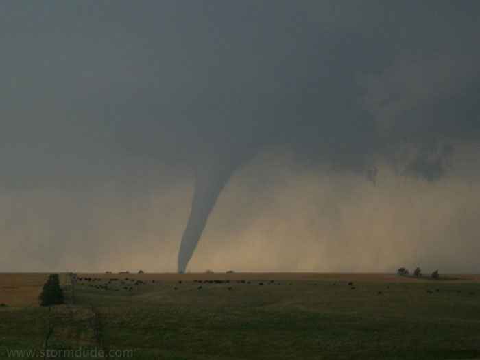
After going all the way back to Hoxie, then back down Hwy23... E on 70 to near WaKeeney, we then saw the tornado near Trego Center, again sporadically when the rain wraps relented and allowed us a peek.

We finally got to 283, where I got some gas.

I went into the men's room, noticed a young man underneath the sink, but proceeded to accomplish my mission. I finally realized why he was under there, and assured him that he was safe, if only for awhile.

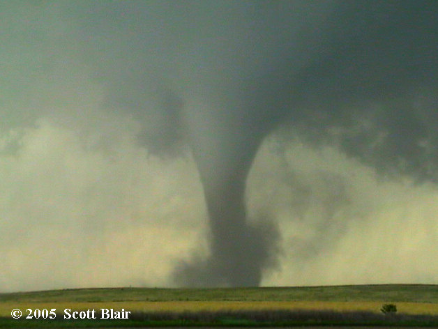
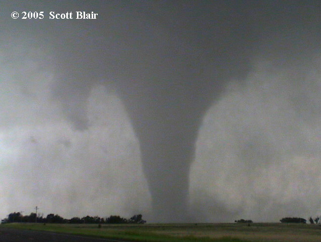
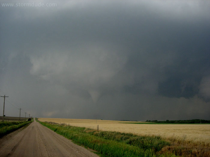
Then we saw another healthy storm to the SW, and drove back W on I-70 to the Collyer exit (baptizing my truck with hail damage), went a ways S and proceeded to film this little beauty for 21 minutes:

http://community.webshots.com/photo/345395...366408697lqvOaL

(Cool vid, Verne...same tornado at the end of it)

What a trip it's been!

Off topic a bit, but briefly: Floss and I have been in battle mode since Memorial Day, and have so far logged 7 tornadoes, I-don't-even-know how many sups, and 4934 miles. We have over 3 hours of vid.

Most of our imagery will be in the form of vid, and I forgot to bring patch cords that would facilitate vidcaps.

Also, most of the time we have been without internet connections in our rooms, thus this is my first post on this marathon.

Special thanks to Bill Robertson and George Tinscher for the nowcasting. You guys rock. You've been there right when it mattered.

Bob
 
My page on the chase is finally up on my website, Click here. I had a video interlace problem with some of the tornadoes during the vid caps, but still a few of the tornadoes I had no problem with...
 
Finally got some time to get my stuff up. Brief synopsis of the chase. Got on the cell building over Abernathy, TX north of Lubbock. At first only seeing some large hail on the ground up to Tennis ball size. Stayed with it as it organized more and more and started turning from NE to E around Petersburg.

Produced the first tornado a few miles east of Petersburg at the intersection of FM54 and FM378. Tornado danced around just south of this intersection for more than 15 minutes in "Wizard of Oz tornado" form before finally making a decidedly eastward push:

petersburgtornado1.jpg


petersburgtornado2.jpg


petersburgtornado3.jpg


when it made it's eastward push it got to be a pretty large stovepipe. I shot most of it dancing around the intersection until RFD blew my tripod over and knocked the battery off the camera. We decided to go up and follow it at that point.

petersburgtornado4.jpg


We lost it in the rain wrap but it was just as well as the road was covered in downed high tension power lines an not passable, so we had to retreat and regroup back to the south and east where we picked it up again at FM54 and HWY70 south of Floydada where it apparantly was just forming a new tornado as we pulled up which got bigger and bigger and bigger until we had a LARGE wedge and a rotating wall cloud so low it looked like you could reach up and touch it. I had to to some adjustments on the pics/video because a number of things was really ruining the contrast, i.e. large amounts of dirt being sucked in, low light (sun was already going down), and my camera lens decided to fog up and I didn't catch it at the time.

Unfortunately, it was moving off the caprock at this time and road networks prevented staying in view range so I lost it there. Stayed with the storm all the way to Dickens county where there was a brief touchdown NW of Dickens. The lightning on this storm several times was just incredible, mostly continuous with several episodes of CG barrage much like the Mulvane, KS storm last year.

floydadatornado1.jpg


floydadatornado2.jpg


floydadatornado3.jpg


floydadatornado4.jpg


I am pleased! 7 good tornadoes so far this year and all of them within 70 miles of home!

Here are a couple of videos, you really have to see the first one for sure.

First Petersburg tornado:

http://wx5tvs.com/chasephotos/2005/2005pic....tx.tornado.wmv

34 megs 5:03 runtime WMV

Second Floydada tornado:

http://wx5tvs.com/chasephotos/2005/2005pic....tx.tornado.wmv

20 megs 5:13 WMV
 
I know this belongs in the "Target Area > Reports". But it seems I'm still "underprivileged." This event is still recent so I thought these images were worth sharing. If anyone can assist in moving to the proper area it would be appreciated.

My Chase Partner Joel Ewing and I caught the Hill City storm and other Rooks county drops (including the "double drop"). A nice finish to a long and sometimes frustrating chase season for me.

Once again It was great to meet up with friends old and new. Look forward to seeing y'all in the field next year. Best to all for a happy, prosperous and short "off season."

Regards,

db


6-9-1.jpg


6-9-2.jpg


6-9-3.jpg


6-9-4.jpg


6-9-5.jpg


6-9-6.jpg


6-9-7.jpg


6-9-8.jpg


http://stormcast.net

MODERATOR: PMed and moved.
 
I will be posting photos later here on REPORTS after I return home.
HOWEVER - I must say that after the doppler truck and the parade of chasers left I continued north through Stockton and saw major wind damage.
THEN it got way too scary and I hope someone can give me an answer.
There was ANOTHER tornado report in this area at about 900 pm and what I witnessed as I drove west of Stockton was life altering. I was blasted by downforce winds and rain on a level never experienced. Approximate time 930 pm. There was no sunlight anywhere, it was black and I dont know how I ever drove out of it. I returned west in hoping to find daylight and as I drove through Stocton I saw people trying to board up windows and clean up damage from the earlier large tornado that swept through the area, even though this NEW event was just unfolding for them and tornado warning were being issued for them.
There was mention on TALK 6/9 that this was a new tornado forming or perhaps a microbusrt.
As appropriate please PM me or post here, especially if you have that radar grab discussed.
 
I appologize for the lateness of this report as I've been occupied by important commitments.

Driving SW on KS 54, not too far West of Pratt, we see our first cell come up at about 2pm, isolated. Slowly it grows, and as approach it, we note a mid-level perfectly formed funnel cloud at the storm's front side. It only lasts for a few moments, and we hope that it is an omen for later today. Before long, the entire storm loses it's cumuliform cloud deck and leaves an anvil.
After this, a number of similar brief storms pop up and quickly lose their cumuliform deck.
A radar check in Dodge City reveals a young storm arising near Meade.
Going South on KS 283, we watch as the storm explodes forth, and quickly has a warning called on it for increasingly large hail. Of course the adrenaline starts rolling; it's the only show in our region.
As we approach it, the NWS calls a warning for baseball hail, and fortunately, we are able to easily stay to well east of the core.
The storm produces spectacular anvil-ground bolts at it's eastern end.
We camp out at the intersection of KS 283 and KS 160 to watch for any wall cloud development at the rain free base due west of us.
Before long, the wall cloud takes shape, first as a stack of plates, and then as an approximately 2 minute dust tube on the ground on the horizon. It's too far away to tell if it's a gustinado or tornado, but just in case, I call it into the Sheriff's office.
Within 5 minutes a ragged wall cloud appears, including over where the dust tube was on the ground. At this point we give chase.
As we ride westward up and down the hills of KS 160, a perfect disk-shaped wall cloud takes shape.
S. of Fowler, we take a narrow paved country road to watch it unfold just to our west through NW.
The storm continues to explode, and we note about 1 mile to our NW the development of a funnel cloud rotating and sucking cloud pieces up into it.
Like fans at a football game, we cheer for it's touchdown. It obliges by developing new links - which we visibally see- and slinks itself down to the ground. Sweet Victory! Its only visible for about 40 seconds before wrapping itself in a shroud of precipitation. I call this in to the Sheriff's office
It's a very HP storm and also cycles spectacular and frequent C-G's that drop very near us.
Within 5 minutes after this tornado disappears, a new one forms about 4 miles to our due west, also heavily rain/hail wrapped, but visibally rotating rapidly. This soon disappears and is replaced by twin stovepipe tornadoes side by side that taper at the bottoms. These also soon vanish in the prec. shield. Very exciting!!!
The action quickly shifts to within about 1/2 mile to our NW. Another funnel droops from the wall cloud and quickly disappears into rain.
This is a rapidly evolving HP storm and swiftly envelops us and a news station vehicle into darkness and intense rain.
Among the goodies that we see, is rotating raincurtains within 3 blocks to our South, as well as a tremendous spectacular wet microburst earlier to our SE whose prec. streaks appear to be literally thrust to the earth as they silhouette upon the brighter background.
Our excape routes suddenly and swiftly get cut off, and we end up spending some time dancing with the bear. This is a first for me, something I don't feel at all inclined to repeat. As we are parked in a large store parking lot along with a couple semi trucks, enveloped in a sea of rain, small hail and darkness - a school loses it's roof about 1/2 mile from our location. Intense!!
When the storm tapers a bit, we make a break for it off to the NE up KS 54, and quickly proceed to get stuck behind an extremely slow moving semi truck. At this point, our excape route again disappears from sight, and we end up driving right under a developing wall cloud (!) and a couple major blasts of wind.
The next town up the road, Minneola has a tornado warning placed upon it from the very stuff we just experienced, and heading straight for town.
In fact they have closed the westbound lane.
We hang out there for awhile and wait, though the storm over Fowler turns almost completely stationary -and HP - so we see no more tubes during this day.
 
Status
Not open for further replies.
Back
Top