06/09/05 REPORTS: Central Plains

Status
Not open for further replies.
Joined
Feb 11, 2005
Messages
69
Location
Minnesota
Interested to see what everyone else intercepted today. Here are a few photos from our chase SW of Stockton, KS. This was my husband's first tornado!

060905_tornado_01.jpg

060905_tornado_02.jpg

060905_tornado_03.jpg


Melanie
 
Caught a tornado about 8-9 miles SW of White Deer in the Tx panhandle (about 30 miles NE of amarillo) on hwy 1880 5 miles north of I-40. Jason Boggs also caught this one and I am sure he will post some pics or video since his video is digital its easier for him to capture and post than me. Biggest hail was about quarter size as I had to drive north then east through part of the core to stay on the storm. also heard numerous reports of a large multi-vortex tornado south of me near Floydada that was on the ground for over an hour. Hopefully tomorrow will be even better.
 
saw three tornadoes today from Hill City to Stockton KS.

the first tornado near Hill City was a stovepipe before it got wrapped up in rain. even after it got wrapped up I could see an intense inflow band and lots of dirt racing towards the tornado from the NE.

inflowtailmed.jpg

storm after it got rain wrapped - inflow band can be seen to the right of the precip

rainwrapmed.jpg

this is all precip - there is a tornado in there though

jogged east a little - got delayed a bit due to road construction on US 24 - then dropped south from Stockton on US 183. a few miles south of town I saw a couple more tornadoes - the one to the south was a pretty stovepipe which I was able to see until ropeout. the one to the north was more of a barrel shape which I eventually lost in the rain.

after that was over I went south to Hays then went west to get another storm near the Trego/Ellis county line. didn't see any tornadoes out of this storm but the structure was just something else.

hp050609med.jpg


hp050609bmed.jpg


all of the tornadoes are on video - I'll try to get some caps up after I get home.
 
Today made chase-cation 2005 worth while. I started about 20 miles east of Dodge City. After watching a little bitty storm to my northwest fizzle due to an unsustainable updraft (around 3PM I believe), I sat for an hour or so pondering shooting towards Trego County. At that time, a storm showed up in southern Meade County. It was pretty close, and had a little rotation, so I headed that way. It was a decision I won't soon regret. It was warned from reports of baseball-sized hail and had a nice little wall cloud by the time I got there. I shot some pics, and then moved into better position. By that time, it was a raging supercell with really excellent photogenic structure around the base. The only thing it had wrong was that everything got rain-wrapped in a hurry, so I had to move a lot. That's certainly nothing to complain about, though. It occluded and re-formed several more times before dark. Absolutely awesome. I can't wait to get back home and stitch together all the panoramics I shot.

For the record, I saw a whole lot of funnels, but only one small tornado that quickly was overtaken by rain. It was getting dark, and it didn't last long, but I might have gotten it in one of my lightning shots for the day.
 
Here are some video captures of the same tornado that Jay McCoy got 8-9 miles SW of White Deer, TX. The tornado was fairly brief and did not do any damage that I know of.


dsc000019lx.jpg


dsc000026xo.jpg


dsc000036tc.jpg
 
First I want to thank SCOTT OLSON and MIKE JOHNSTON and my nephew RYAN for their undying nowcast guidance.....their help put me into the kind of chase you dream about.
In short a 450 mile run that originated in Denver netting me a HUGE elephants trunk in Damar, Kansas on the ground for 12 minutes.
pics to follow....gotta get ready fore tomorrow.

bill
 

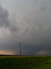
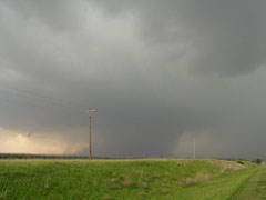
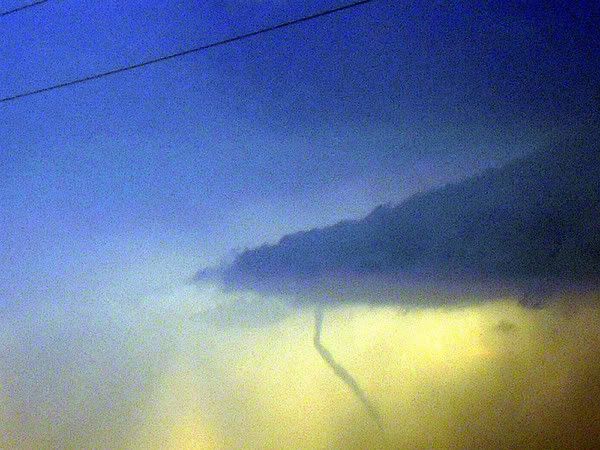
Trego County, Kansas near Trego Center ~2235z

In chasing it is often better to be lucky than good, and today I was very lucky and only good enough to avoid screwing up one of the great chase days of the last few years. June 9 deserves a place alongside the best chase days in recent memory, producing a wide range of violent, photogenic tornadoes from south of Lubbock, Texas well into Nebraska.

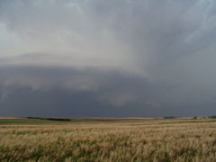
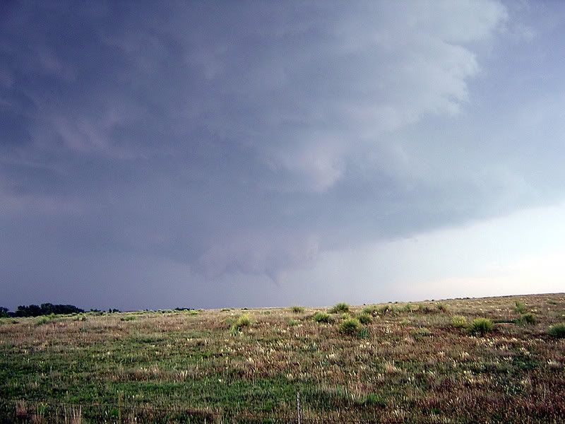
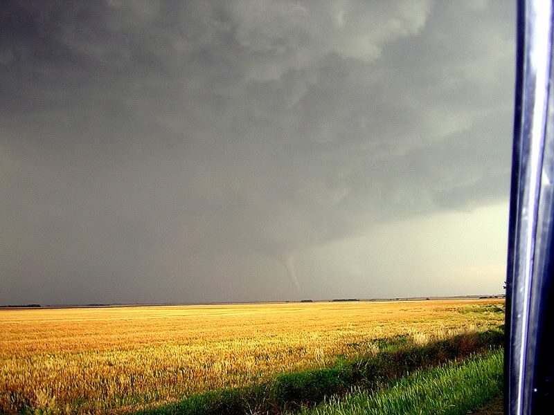
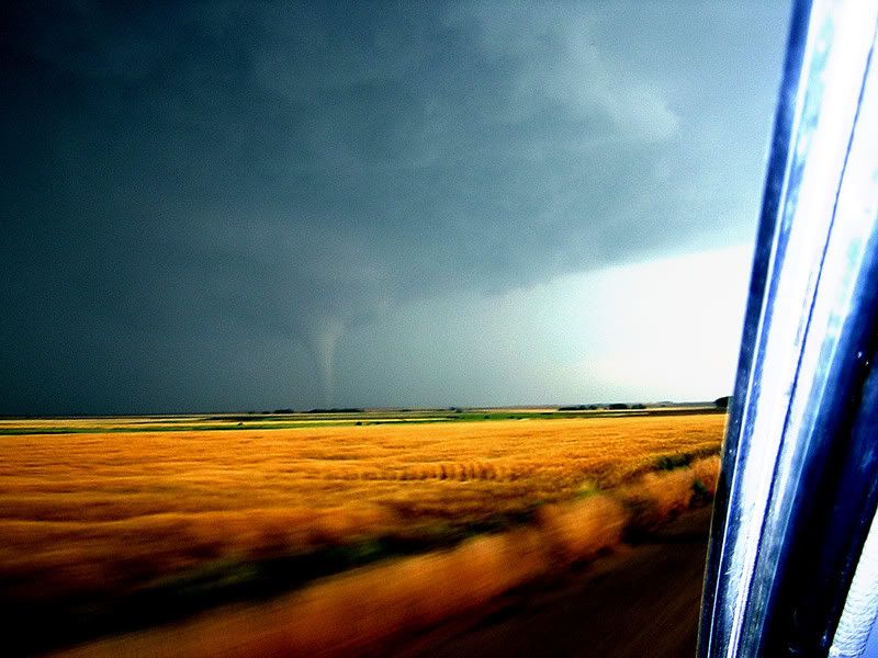
I witnessed four tornadoes from the storm that began in central Ness County Kansas and moved into Trego County where it wound up and developed several large cones, funnels, and stovepipe tornadoes, along with the most violent rear flank downdraft winds I've ever seen.

I started in Sterling and raced south, thinking the outflow boundary and dryline would intersect somewhere in the eastern Texas panhandle. But the surface low in southeast Kansas was ejecting faster than the 9z RUC model had shown, and my intersection point was progressing steadily northward. This was a good thing, too, because construction slowed me terribly in Colorado. If there had only been the one storm near White Deer (which did produce a tornado, according to several chasers), I would have been hard pressed to arrive in time.

I revised my target to Beaver, Oklahoma, then finally Dodge City, Kansas. I arrived at Dodge in time for the first small storm that fired ahead of the dry punch. At this time, the Hill City area storm was cranking up, and I knew my friends were up there bagging tornadoes like a shopping spree. My little cell by Dodge died rapidly, and I noticed the storm two counties north, in Ness County, was shaping up nicely. I hurried back up 183 and intercepted this storm about ten minutes before it began exhibiting rapid rotation---the most violent cloud base rotation I have ever seen. It spun and spun and I was amazed that such a violently turning storm was not condensing or even building downward. Then suddenly everything changed.

As the storm snagged the boundary, it began rapidly updrafting new condensation, and the show was on. The first and second tornadoes are so remarkably similar at one stage of their lives, it's nearly impossible to tell them apart, with the perfect collar cloud orbiting each. But the second tornado morphed into a large elephant trunk that touched down ~2240z and began to cross the road in front of me. This was about ten miles south of Wakeeney on 283, very near Trego Center, Kansas. This tornado was on the ground for nearly fifteen minutes. Then it lifted and another came down--not the same funnel; clearly separate post-occlusion tornadoes. This one began moving to the east northeast and I was behind, since I had allowed the tornado to cross the road in front of me. Unfortunately, my camera was zoomed all the way out and so my video makes it look as if I was further from the tornado than I was. Not that it matters, but it was so breathtaking that I stopped shooting digital stills at one point and stared in awe. I like doing that once in a while. The obsession with recording this stuff can sometimes interfere with the actual experience. It's good to put the cameras down for a few seconds and humble yourself before something so majestic.

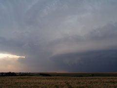
I called Dodge City NWS to report the tornado (I had cell service for once!). Then as I turned east to follow, a large RFD plume was roiling in the field ahead of me. Then I observed an area of flattened vegetation moving rapidly, with some of the vegetation being pulled out of the ground and flung through the air! This was RFD--there's no question. But it was particularly violent and I turned south to escape and took the next east option. Strange as this sounds, that RFD was more unnerving than any of the tornadoes, including the one not far from me.

When I rounded the corner again, a white cone tornado was still on the ground. This was either the third tornado which had never lifted or simply a new one. After this, a new mesocyclone to the west produced another brief tube, and the show was over. The storm elongated and the shear weakened. Amazing what can happen in about four hours.

Special thanks today to EricN and ScottB for comparing notes on the forecast, and congrats to those guys for the getting the best of BOTH storms, Hill City and Trego County.

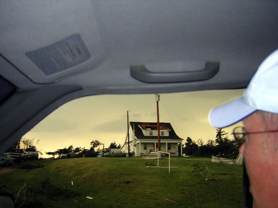
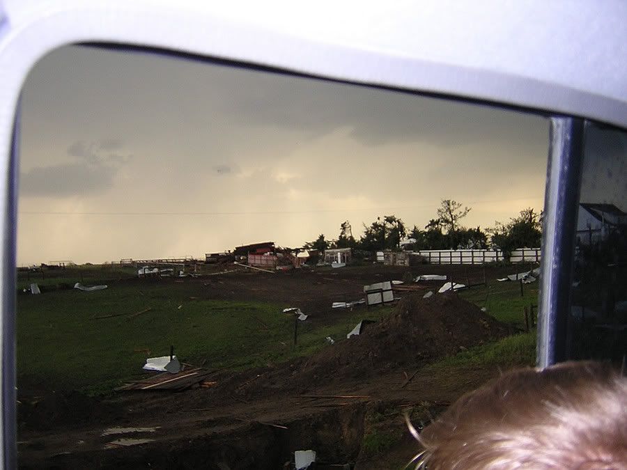
We have heard reports of damage to homes and property and hope the residents of northern Kansas made it through this dangerous night safely.


This is not my report.

Derek Shaffer, Ryan Herman, and Beau Hemel headed out of Dighton Kansas, after Ness county cell was warned, caught up to them in Trego Co. Here are some shots of damage and the tubes. ~10 south of Wakeeney.

Photos too big, CLICK ON THUMBNAILS.


Today was awesome. I was on the Meade county KS storm and got four tornadoes. I was focusing on video today so I never even got out my digital camea (all I have is video grabs). There was a very broad area of rotation during the first three tornadoes. It wasn't the classic clear slot from the RFD, where you can tell where the tornado was going to develop. In most cases today, by the time you realized where a tornado was going to develop it was too late to get out of its way. There was also rain wrapping around the meso so you had to get in close. It was a bad combination and it made for tough chasing even though the storm was virtually stationary. The first tornado dropped a few miles SW of Fowler. It touched down about a half mile to a mile in front of me. I moved in closer and got good video of it crossing the road from about 100 yards away. Here are two pics of the first tornado. It didn't last very long.

my.php
[/url][/img]

my.php
[/url][/img]

I thought the car in the second picture was done. The tornado could not have missed it by much.

The second tornado was about a mile SW of Fowler. It was about 100-200 yard wide cone. It lasted a couple of minutes.

my.php
[/url][/img]

The third tornado touched down about 100 yards in front of me. I never got any video when it had a good condensation funnel. I had to put the camera down and sprint down the road because the tornado was coming South towards me. The first picture was of the funnel right before the circulation became visible at the ground. You can't make it out very well. The second picture is the circulation at the ground with a little bit of debris. It crossed the road about 100 yards South of me and died quickly.


After that tornado I moved East where a new mesocyclone developed. I saw several funnels close to the ground, but I never saw any circulation at the surface. The storm began building back to the South after about 20 minutes. I dropped South on 283 and went West on 160 where I saw the fourth tornado. It touched down once when I didn't have my camera on and then touched down a second time once I had my camera ready. Here is a video grab.

my.php
[/url][/img]

The span of time around the fourth tornado was quite scary. There were tons of cloud to ground strikes going on all around. It was the worst lightning I have been stuck under. I have a soft top Jeep, so I was sweating bullets over the CGs. There were several that hit very close to my car.
In conclusion, 2005 just got a little bit better today. I wasn't real happy with the tornadoes, but I can't complain. I got some real good video out of the deal because of how close the tornadoes were. This was the first time I have ever felt truly vulnerable when chasing. It wasn't that the tornadoes were strong or anything like that. It was just that the combination of having to be in close, rain wrapping, and the very broad area of rotation for the first three tornadoes made it difficult to find a safe place to view from. I had several close calls with funnels and tornadoes today. I kind of wish I had stayed up North. I originally went to Hays this morning before haulling South around noon. It was still a great chase though and I certainly won't complain. I am spending the night in DDC and can't wait to see what tomorrow will bring.
Congratulations to everyone else who bagged tubes today.
 
Excellent day. We go onto the first supercell (the one that produced the Hill City wedge) early on in it's lifespan, and got a couple funnels (after getting stuck on a dirt road, and wasting time), and had to deal with idiot construction workers, who were absolutely oblivious to the oncoming LARGE tornado that was ongoing. All in all, I probably got around a half dozen tornadoes today, likey more. Here's just one still I got to upload...

structure w/cone tornado - and developing large funnel to the right of it
tn_9-June-2005-RAW018.jpg


Will have a log/photo set on my website soon, but am so darn busy, lol...

Onto tomorrow!
 
A very frustrating day for Brian M, Kinney A, and myself. Began the
day in Ogallala, NE videotaping a humorous t-shirt transaction
between Kinney "the gardener" Adams and Dave Fogel. This ended up
being the high point of the day. Headed S to Imperial for brunch;
with plans to head S into NW KS. Noticed early CB-o-genesis
transpiring E of Benkleman. Headed S to Oberlin, arriving to tornado
warned convection. Got hailed on briefly before turning around to
target the beast towards Morland (Sheridan/Graham Co). Sirens blasted
off in Oberlin as we headed S on HW83; yet was perplexed as to why
(nothing visually; nor on threatnet). Apparently a tornado was
reported 20 minutes after we abandoned the cell.

Expedited southbound on 83; then cut S on 23 to 24 east. Finally on
course to Hill City; Keith Brown phoned to report a large wedge
tornado SW of the HLC. A large hail/precip. shaft was visible east;
so in an attempt to dodge that bullet; our entourage cut S at
Penokee. Big mistake. While skirting eastbound on a dirt road; it was
decided not to proceed and return to 24. During this; I attempted to
turn around into a small driveway, under-estimated the turn and
slipped into a deep ditch. #@$#@!!! This qualifies me for the
jackassery of the year award. Fortunately, a local farmer had us
out of there in 15 minutes!

Headed N to 24 and proceeded E. Decided to leave the TOR warned cell;
and headed S to the Eillis Co. sup. Managed to make it to I-70 to
witness two brief tornadoes; low contrast; one just SW of I-70 near
Riga (or Ogalla); followed by a brief tornado N of I-70 NE of Riga.
Storm quickly transitioned into HP mode; and regardless of additional
attempts N of Hays.. only a rotating wall cloud was observed. Chase
ended at Arbys in Hays, oogling over Bill Reid's multiple tornado
video bonanza.

Currently in Pratt; drinking a Dr. Pepper and analyzing data for the
next several days.

..Blake..
 
What an awesome day. What an HP beast!!


Very close report to Michael Gribble's above.


Did not leave ICT until around 3:30 pm, not originally planning to chase today. After looking over some data, decided SW KS was a must-go and decided I had a shot to make it by 6.

Arrived near Fowler, KS Around 6:30pm right when the first tornado warning was issued. Persistent wall cloud was present just west of Fowler. Watched this feature as it spun itself out over the next 10-15 minutes, was almost positive it would produce a tornado, never did. Watched as another area of rotation began to develop right near HW 54 W of Fowler. This feature quickly began spinning rapidly and the first tornado formed around 6:47pm, it began as a very thin rope tornado and transitioned into a decent sized tornado as it neared HW 54. The tornado moved right over HW 54 (I was about 1 mile E at the time) with a full condensation funnel and some fairly strong rotation. Followed the storm south and was able to observe tornado #2 from S of Fowler, it was a good size cone that lasted around 2 minutes, barely visible from my location due to rain wrapping around the tornado. Continued south and was able to observe a 3rd tornado closer to sunset, thin rope tornado.

The real treat was not the tornadoes but the unbelievable structure shots I was able to take after setting up shot for about an hour about 5 miles E of the storm, watching it sit and spin. I was able to witness and tripod the most amazing CG show I have seen in my life!!!! You really had to be there to believe, it was worth the trip 5 million times over.

Overall, great day, especially considering I was originally not even heading out. Was a very difficult storm to chase early on considering every tornado was quickly rain-wrapped. The hilly area S of Fowler did not help much either with viewing. Best decision of the day by far was deciding to screw trying to get close to another tornado and just take in the sights of a raging HP supercell over the KS prarie complete with a CG show and tornado #3, I can't ask for more.

Congrats to all others who nabbed the tornadoes today!
 
What more can I say that hasn't already been said? :)

From Stockton, KS:

a.jpg


b.jpg


d.jpg


f.jpg


g.jpg


Northern Ellis County, KS
i.jpg


Trego County, KS
l.jpg


Congrats to everyone out today; it certainly was, IMO, THE day we've all been waiting for (so far) of 2005!

BTW, I'd be remiss if I didn't thank my wife for leaving work early today and coming along with me. She lost her tornado virginity today! :)

EDIT: Wow. Melanie's husband and my wife see their first tornadoes today and it's the same exact ones! Got to appreciate the coincidence in that! :)

Regards,

Mike
 
Status
Not open for further replies.
Back
Top