WSV3 Next Gen Software

Joined
Apr 8, 2015
Messages
19
Location
Plainfield, IL
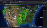
I just wanted to get everyone's thoughts on this new software being released tomorrow. I've been following their facebook page for awhile, and it looks pretty interesting. Tomorrow and tomorrow only they're offering a discount on the software, so I was tossing around the idea of purchasing it. It looks like a great Level 2/3 Radar data source plus so much more. Models, satellite, mesoanalysis, etc. Has anyone had the chance to beta test it, or anything? Check out the website here: http://wsv3.com/.

Thoughts?
 
I spent a lot of money on their last "revolutionary" weather package and it's been sitting dormant for years, with promises of future improvements always unfilled. FWIW.

And any product calling itself "the new standard" and the market leader within days of launch also makes me go hmmm...
 
After playing around with WSV3 for a few hours, my overall first impression is "Gimicky". It has a very colorful interface that might appeal to some people, but being a long time IT guy, I'm more impressed by functionality, and data. What can the app/utility do for me. etc..

In general, the tools I currently use are GR Level 3 for radar, HazWX for models, and the SPC Mesoanalysis page for current obs. Though I am not currently a GR Earth user, I have been considering it.

I had hoped that WSV3, based on the aggressive pre-release marketing claims, would possibly be a one-stop shop for me, and replace all 3 tools. I just don't see that happening right now. WSV3 does not currently provide all of the data that GR3, HazWX, SPC MA provides me.

GR3, while it doesn't have a fancy interface, is very functional and easy to use from a radar standpoint, and HazWX (or even TwisterData for that matter) provide very good Model analysis, and SPC MesoAnalysis web site is sufficient enough for current observations/analysis.

Perhaps, GR Earth combined with GR3 is the right solution for me at this time?

I'm going to explore WSV3 some more today, but not overly optimistic at this point.
 
I haven't tried it yet, but it seems to me that if you've used GR products and have a basic understanding of how to obtain and interpret radar data, change color tables, import placefiles and shapefiles, and the like, then WSV3 really doesn't offer anything you can't already do using GR.

Unless I discover it really offers something truly unique and useful, I probably won't bother to spend money on it.
 
I've been playing around with the trial, it seems it is lacking in a few key areas. It seems to be fairly well put together, a little more refined than GR, and fairly easy to use with several different aspects to it. The only problem is it gives a bit of everything, rather than ALL of everything. It looks cool, but time will tell how functionally sound it is and if it holds up to as cool as it looks. I'm going to play around with it a bit more, adjust some of the crazy color palettes, and then make a decision on whether or not to purchase it. Overall however, it looks like a pretty good product.
 
After playing around with WSV3 for a few hours, my overall first impression is "Gimicky". It has a very colorful interface that might appeal to some people, but being a long time IT guy, I'm more impressed by functionality, and data. What can the app/utility do for me. etc..

In general, the tools I currently use are GR Level 3 for radar, HazWX for models, and the SPC Mesoanalysis page for current obs. Though I am not currently a GR Earth user, I have been considering it.

I had hoped that WSV3, based on the aggressive pre-release marketing claims, would possibly be a one-stop shop for me, and replace all 3 tools. I just don't see that happening right now. WSV3 does not currently provide all of the data that GR3, HazWX, SPC MA provides me.

GR3, while it doesn't have a fancy interface, is very functional and easy to use from a radar standpoint, and HazWX (or even TwisterData for that matter) provide very good Model analysis, and SPC MesoAnalysis web site is sufficient enough for current observations/analysis.

Perhaps, GR Earth combined with GR3 is the right solution for me at this time?

I'm going to explore WSV3 some more today, but not overly optimistic at this point.

After more time spent on the trial... I've made my decision.

Despite the lure of the opening day discount, it's still a big price tag for a product that at this point seems incomplete. I am pulling the plug on this testing at this point. I'm not going to pressure myself into going for the discount for something that may never be fully developed, or ever meet my needs. I'll take my chances and hold off on the expense for now.

I will be keeping an eye on the progress though.

-matt
 
I tried it out as well. I was actually surprised that it was consistently beating GR2AE in refreshing the L2 radar scans; sometimes by wide margins.
This is one thing I noticed bigtime. It beat it out by over a minute, sometimes even more. Definitely one of the pros to the software.
 
Well.. blame it on exhaustion I guess..

I woke up in the middle of the night to participate in insomnia club, and that usually doesn't bode well for my wallet. Most of the time it's Amazon, but this time pulled the trigger on the WSV3 purchase 4 minutes before the discount cutoff. I really hope I don't regret it, but only time will tell I guess.

:(

Will someone please come put a block on my internet access after 10pm please... K' thx!

-matt
 
I messed around with it a bit yesterday - Probably 30-45 minutes. It seems like a decent hobbyist software, and I can see a lot of uses for it and a lot of potential.

One place I don't see a lot of potential yet is chasing. The level3 products are WAY too hard to change between, there's no way to step back and forth with keyboard shortcuts in a radar loop, you can't display full metars nor did I find anywhere to display other data (Spotter Network icons for example).

Gimmicky is the best way to describe it in my opinion - I hope eventually there is more development and more refinement. It's obvious that a lot of work went into the product and something that could easily replace GR3 would be nice. Right now I have to run 2 copies of GR3 one with reflectivity and one with velocities because they did away with those handy tabs.

GPS support is supposed to be added, so that will be helpful on WSV3. Still holding off on spending my $. Hoping they do another promo in the future when the direction of development becomes clearer.
 
Good move on waiting. I wish I'd done that with the previous software - instead I bought two licenses based on "coming soon" and we're nearly two years out and I still can't plot QPF.
 
Perhaps, GR Earth combined with GR3 is the right solution for me at this time?
I'm going to explore WSV3 some more today, but not overly optimistic at this point.

One of the reasons I tried this software is that while I've been a long time gibson ridge user, I found GR earth to be very frustrating to use. It took a long time to load things and wasn't always clear to me what it was doing.

I'm not a forecaster, more like a power user, and the interface for this software (so far), with a little poking around, just lines up better with the way my brain works.

Especially once I found that holding the right mouse button activates zoom. Just as a radar browser with that feature it blows away many other programs. It definitely needs some documentation, though.

For the long term, we'll see, of course...

John
 

Attachments

  • cold front.png
    cold front.png
    1.3 MB · Views: 436
Back
Top