• While Stormtrack has discontinued its hosting of SpotterNetwork support on the forums, keep in mind that support for SpotterNetwork issues is available by emailing [email protected].

Winter Storm - 3/4/15 to 3/8/15

Joined
Aug 16, 2005
Messages
234
Location
Waxahachie, Texas
Thought I'd jump in here and start a thread regarding the next winter storm this week starting up in Texas. There is some indication by the models this morning of the potential for a major ice/sleet storm for the Lone Star State. There is also the potential for little if anything to happen too, but right now, the trend is towards a major winter storm. There are hints of liquid amounts of 2" and possibly more, so this one really bears watching.

The 12z NAM was considerably slower with the arctic air arrival which is curious as it is often the faster and more accurate solution with regards to arctic airmasses crossing the Red River. Personally, I am discounting that solution as of now considering that Texas arctic fronts almost always arrive ahead of model forecasts.

Hopefully the models will come into better agreement in the next 24 hours.
 
Looks like it could be a nasty storm for much of Texas. I agree with Texas fronts almost always coming through faster than anticipated. Seems like most places have struggled to even get to 40 degrees today, when there were forecasts of 45-55 for highs.
 
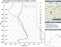
This system is a pain to forecast...but I'm sure I can speak for the people in middle TN that we don't want any more ice...but I don't see a way around that unfortunately. NAM and GFS upper air soundings seem to agree on one thing...freezing rain. Just how long we get FZRA, what the length of transition is from rain to snow, and how fast that cold air comes charging at us is so uncertain even 48 hours out. NAM wants to slow the arrival of air (overnight into Thursday morning) while the GFS blasts us with cold early evening on Wednesday and wants to drop another half inch of ice...because you know...we haven't had enough ice.
 
Morning forecast models are looking pretty ugly for Arkansas into far western Tennessee and into Kentucky. Somewhere along that southern periphery of that area could be dealing with a crippling ice storm. As far as Texas, 12z models rolling in are indicating a significant uptick in the precipitation amounts and hinting at isolated embedded thunderstorms now for North Texas (DFW region) into NE Texas. Definitely a serious concern given the vertical temperature profiles are pretty unclear right now.
 
NAM has been spitting out these sounding for a few runs now. I think the saving grace right now for us not having a third ice storm is that the air gets so cold so quickly between the freezing layer and the ground...precip will refreeze before it reaches the ground. Sleet, sleet, and more sleet. I'm still learning winter weather forecasting, and know what classic FRZA and sleet soundings look like, but would you concur with my previous statement?upload_2015-3-3_17-31-35.png
 
Water vapor loop this morning was pretty interesting. The core of the upper level trough had a compact and closed circulation as it passed over the Baja Peninsula. There is also another disturbance on the back side to the west of Baja which I don't see was picked up by the models. I'm thinking the models are underestimating this entire system. This is going to be very interesting to watch unfold. I noticed some of the incredible snowfall forecasts up around Tennessee/Kentucky areas. Yikes!!

For North Texas around DFW, we are under a winter storm warning and if my hunch is right about the water vapor analysis, it is going to exceed current forecasts. I'm looking forward to some heavy thundersleet storms overnight. :-)
 
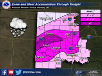
This has been a huge bust thus far in the OKC area for the early show but OUN is still holding on to some reasonably decent snow totals for the area. OUN Sno.jpg

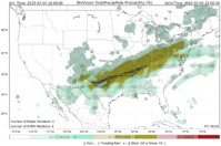
@Steve Miller TX, here is an internal graphic we use at WDT that was sent to me earlier. Thought it was a bit interesting for your area:
Screen Shot 2015-03-04 at 10.56.08 AM.png
 
Regarding North Texas, the radar trends haven't been following the 18Z NAM forecasts. Each HRRR run increases the precip across the area. I can't help but think this is due to the upper level system not being initialized well and it is stringer than forecast based on the earlier WV loops. Some lightning strikes are noted now west of Del Rio and one just noted near San Angelo. Radar is really lighting up out there and indicative of the strong dynamics coming in. Temperatures are now pretty much at or below freezing across DFW with a band of heavy convection moving in. This is going to be ugly.
 
There's no doubt this is going to be a newsmaker for #DFW. Ice already accumulating on tree limbs and plenty of wind to aid in breaking said limbs.
Was just reading about the power situation in north and east TX. Turns out many of the back-up coops DFW depends on are currently staging over in the Mississippi area where .25" of ice is expected. Might be an interesting night for many.
Regarding OKC, a very strong band set up just to the west of the metro and has pushed on through at this hour but the school closing damage has been done!
 
12:30 AM and most of the metroplex has ended up with .25" of ice and 2-2.5" of snow. Obviously some higher and lower accumulations throughout. Its been an interesting evening trying to get folks to provide reports as the NWS folks were working to refine the impacts. Going to be a very messy morning for the drive to work!
 
Officially, this is the 4th "snowiest" event in March for DFW and the "snowiest" in 68 years. The all-time record is 6" which occurred on March 13, 1924. Second place is 4.5" set on March 1, 1942. As you can see on this graphic, just the slightest shift of the heaviest snow band would have made this event #2 or even #1. So indeed, a pretty rare event for North Texas. Watching the news this morning, it looked more like January or February across North Texas. Also interesting to note that the the 12z, 18z and even 00Z (just as precip was increasing) runs of the NAM kept reducing the precip amounts with each successive run. The HRRR however started picking it up and seemed to to best overall leading up to this event. I think the Texas Tech WRF did a pretty good job too. It would be interesting to read a forensic analysis of this event compared to the different model forecasts and why each model nailed it or missed it.

11045289_10205065158021435_6335132813309183106_o.jpg
 
There has been a lot of DFW discussion in this thread, but this storm has been very impressive in a wide range of places all across the country. Out here in my neck of the woods, the Wolf Creek Ski Area ended up with a very impressive storm total, over 5 days or so, of 64 inches. Add that together with the previous weekend's 42-inch storm (discussed in another thread here), and you get a 2-week total that is approximately equal to Boston's near-record season total. At my house in Pagosa Springs, about 3,000 feet below Wolf Creek Pass, we have received 31 inches in the past two weeks, including about 13 from the latest storm. Could have been quite a bit more, but warm days and mixing with and at times completely changing to rain held down the total.

In other parts of the country, this same storm was responsible for the hundreds of motorists stranded overnight (and in some cases, for much of today as well) on Interstates 65 and 24 in Kentucky, where some locations got over two feet of snow, and for the airliner that slid off the runway at LGA. From hail accumulations on the beaches of LA through all the places discussed in this thread to the eastern end of Long Island, this has been a true coast-to-coast storm.
 
Back
Top