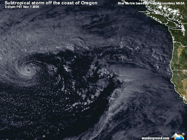
Wow... what an unusual little storm! I think about the only thing that can be said with certainty about it is that it's a mutt. The satellite image that Marc put up earlier shows the best of its warm core characteristics... tight spiral form, eyelike feature, convective banding. You can also see some of the features nearby that argue for extratropical/cold core, like the decaying occluded front northeast of the low and the new wave developing on the cold front approaching the west coast.
I want to call this a polar low, since it's in the cold air poleward of the polar front and the convection was pretty shallow. I don't think I've ever seen such a nice spiral form polar low in the Pacific so far to the south though. From what I've been able to tell so far (and someone please correct me if I'm wrong), the 500 mb heights and temps aren't particularly low/cold in the area, which makes for a non-ideal environment for a polar low to develop... but SSTs are unusually warm in that part of the Pacific so maybe the thermodynamics were good enough.
Either way (polar low, hybrid, subtropical), it's a really neat storm and a great discussion item. There are parallels between it and the South Atlantic cyclone in 2004 (see the
UW-CIMSS archive of images and other goodies), and some of the spiral form polar lows that occur in higher latitudes.
BTW, the Navy is maintaining info on this system on their
tropical cyclones page (at least for a little while longer), as "Invest 91C".
I wonder if any ships or buoys passed close enough to the center to get a good read on the pressure? I saw estimates around 990 mb or so earlier today with gale force winds... but it would be nice to get an actual ob.
Oh, and before I forget, it's good to be back on ST.
")