"Veer-back" - impacts of backing aloft in supercells

Jeff Duda

site owner, PhD
Staff member
Site owner
Supporter
Joined
Oct 7, 2008
Messages
3,798
Location
Denver, CO
Many regular chasers are probably familiar with the "veer-back" (or veer-back-veer; VBV) feature of forecast and observed hodographs and their relationship with disappointing storm chases. Most have noted in their own adventures that when backing is present aloft, storm mode becomes messy and the day usually ends up with little in the way of impressive structure or tornadoes. Since there is no formal thread on this forum (that I could find) on the academic background on the "veer-back" (hereafter, VB), I figured I would present this informative module on the subject.

Definition of veer-back(-veer)
VBV refers to a backing of the winds in a layer above another layer with veering winds, and sometimes bounded above by another layer with veering winds (hence the second -veer in the name). The image below illustrates this feature:
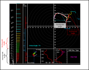
vb_ex1_annot.png

I personally choose not to use the second "-veer" when describing this phenomenon since it seems to have little importance in the overall issue and is not always present. But to each his/her own.

For practice, the un-annotated image is linked below:
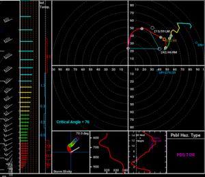
VB_ex1.png

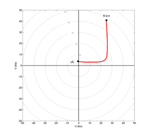
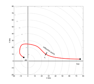
Before continuing on, I want to point out that what many refer to as VB is really a specific example of a more general phenomenon. What is really happening is a reversal of the curvature of the hodograph. While it is common for veering winds to be associated with clockwise/cyclonic hodograph curvature and backing winds with counter-clockwise/anticyclonic hodograph curvature, such a relationship is not required. The idealized example below shows a hodograph where the curvature switches from cyclonic to anticyclonic at an inflection point, z_i, even though the actual winds continue to veer through the inflection point itself.

(Note: at this point, if you are lost in the terminology or don't get it, I recommend a basic primer on hodographs, which I have not included here.)
general_vb_hodo.png

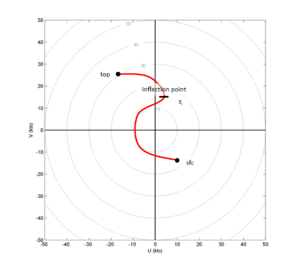
In the idealized hodograph above, there is cyclonic curvature from the surface to z_i and anticyclonic curvature above that. While still idealized, this is still a representative example of many hodographs seen in the US during the spring season. To drive the point home, I've included a very generalized example of this which is generally not representative of what you see in real life, but which exemplifies the true characteristics of this phenomenon:
general_vb_hodo_2.png

The characteristic shape of this hodograph lends itself to another name commonly used to describe it: the 'S-shaped hodograph'. When the "kink" or inflection point is more obvious, the association between veering and cyclonic curvature/backing anticyclonic curvature strengthens and becomes more evident.

Okay, so what's so important about VB?
The fundamental atmospheric quality that distinguishes supercells from non-supercell storm modes is vertical wind shear, which is best depicted by examining hodographs. Vertical wind shear is represented by the length of the hodograph, specifically, the distance in U-/V-wind parameter space (the axes of the hodograph) between two vertical levels. Typically the surface and 6-km AGL levels are used to define "deep layer" wind shear used to discriminate between supercell storm modes and non-supercell storm modes. Since the magnitude of shear is rather important (perhaps of first-order importance), supercell storms can still occur even with S-shaped hodographs. However, hodograph curvature tends to indicate which type of deviant motion is preferred. Cyclonically curved hodographs favor right-moving supercells. The reason for this has to do with how the shear vector interacts with the updraft of a storm and also on storm-relative helicity (it will be assumed that everyone knows what that is and how to analyze it). So when you have a combination of cyclonic and anticyclonic curvature, SRH is reduced for two reasons: 1) the inclusion of the area bounded by anticyclonic curvature; 2) the storm motion vector is closer to the hodograph itself, which reduces storm relative flow. Reduced SRH leads to less propensity for sustained updraft rotation, even in the presence of sufficient deep layer shear, and increased storm relative flow is pretty much always better than the alternative. Boring stuff happens when storm relative flow is small.

In summary, with S-shaped hodographs storm modes tend to get messy, even if the forcing supports cellular convection.

VB and tornado potential
Just the presence of VB/S-shape in a hodograph does not automatically preclude tornado potential. Tornadoes depend much more strongly on low level shear than deep layer shear, and many S-shaped hodographs still contain sufficient low level shear for tornadoes. So why are tornadoes still less common in environments with S-shaped hodographs? Tornadoes cannot just form out of nothing. They need a supportive/nurturing environment, which includes sufficient buoyancy to accompany that shear, and basically an absence of something else to screw all of that up. Downdrafts, outflow, and cold pools can be excellent tornado disruptors, especially since they are sources of negative buoyancy and downward accelerations (both of which are toxic to tornado production). Since environments with S-shaped hodographs tend to favor messy storms, it's usually the behavior of the parent thunderstorm that restricts or eliminates the favorable environment for a tornado to form. Tornadoes can still form if the environment doesn't get too messed up, but it is simply more common for disruption to occur with these hodographs.

My hypothesis about how impactful S-shaped hodographs can be on supercells
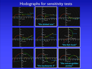
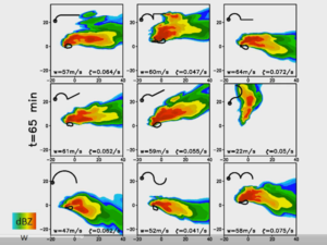
In the 2016 Severe Local Storms Conference, Matt Parker presented some research on the impact of VB on supercells (https://ams.confex.com/ams/28SLS/webprogram/Paper300986.html). A cursory examination of his results surprised me, as he tested several hodographs that featured either VB, a kink, or some sort of S-shape (all examples of the reversal of hodograph curvature). This led to a broad conclusion that VB really doesn't matter when it comes to supercell behavior. This result seems at odds with my own personal observations, and I think many other chasers would agree that storms seem to struggle to get or stay organized in environments with S-shaped hodographs. The research Matt did looks legitimate, so I had to follow along more closely to see where the discrepancy arises. My hypothesis is that the height of the inflection point (where the hodograph curvature reverses) is critical in determining whether supercells will thrive in an S-shaped hodograph environment. Specifically, when the inflection point is higher, it is more likely that supercells will thrive. A general threshold seems to be about 3 km AGL. In the 9 hodographs he tested (below; shamelessly ripped from his recorded presentation), the inflection point is below 3 km in only one hodograph - "the fish hook" - and that is the only case in which a sustained supercell does not appear:
hodograph_matrix.png
results.png

This is a bit subtle, but here is the explanation. If you're familiar with SHARPPY, then you know the hodograph color changes from red to green at the 3 km AGL mark. In the 7 hodographs above that have an inflection point, in only "the fish hook" hodograph does the inflection point occur in the red section. Even though it appears visually slight, it is there. And the results show that a storm struggled to survive in that environment. Surprisingly, he did not discuss the 0-3 km SRH values in these hodographs except for "the fish hook" which had 69 m2/s2 0-3 km SRH, a puny value if you want supercells. 0-3 km shear (not SRH) has been shown in some recent research to be a potentially skillful discriminator between weak and strong tornadoes, and it's not much of a stretch to consider the discriminatory nature of 0-3 km SRH to supercell and tornado production in general. Matt did mention at the end of his talk that it would be worth testing the sensitivity of these simulations to the height of the inflection point, but to my knowledge this research has yet to be conducted. I suspect whoever does it will find decreasing sustainability/organization in storms as the height of the curvature reversal decreases.

TL;DR
When assessing the impact of VB(V) on storm organization, the height at which the backing begins is probably pretty important, with increased potential for sustained supercells with increasing height. So don't despair just because you see VB in a sounding. You can still get relatively clean supercells and tornadoes with S-shaped hodographs. In fact, there was a little nugget towards the end of Matt's presentation suggesting that above a certain height, some degree of backing can actually be beneficial in that it can restrict left movers/splits, thus keeping the environment relatively undisturbed and allowing storms to rage for much longer.
 
Last edited:
Great write-up - I was hoping someone would do some objective analysis after all the veer-back talk last year. This touches on the questions I had (veering/backing winds with height vs cyclonic/anticyclonic hodo curvature and at what height the kink negatively impacts supercell behavior).

After getting hosed by veer-back on April 26 and May 8 last year I'll definitely be paying more attention to 0-3km SRH and hodo curvature. The cells on May 8 near the KS/OK border launched very fast-moving, sustained left-splits which destroyed any chance of my target producing. Looks to me like 0-3km SRH can still be pretty sizable even with the kink reaching down into the 0-3 if the cyclonically curved area below that is large enough.

I wonder if there'd be value in applying machine learning to a large dataset of hodo curvatures to produce a set of probabilities for different types of supercell behavior given a hodo.
 
Please engage me in discussion here, as this is not exactly textbook worthy just yet, and some of this remains just my personal hypothesis. I was hoping @Jeff Snyder would get in here and offer his take on the issue since I know he has more experience/knowledge on the subject than I do.

Also, I'll use this post to address a question or two in the chat from @StephenHenry:

Regarding the possible benefit of anticyclonic hodograph curvature at higher levels

In Matt's presentation he noted that in some simulations left splits were greatly suppressed compared to others. This was actually one of Matt's 4 points of discussion in his talk (the impact of backing on storm splits/mergers). You can see from the animation on one of his last few slides that the cellular mode is maintained pretty cleanly in several simulations, especially ones featuring an overall large amount of cyclonic hodograph curvature. That is in contrast to one of the simulations that had a quarter circle turn followed by a straight line hodograph aloft (the bottom right one). In this simulation the prominence of the straight portion of the hodograph was enough to allow for left and right splits to be almost equally favored, and therefore left splits survived much longer than they did in the simulations with much more cyclonically curved hodographs. The subsequent storm interactions basically killed off the storms in these simulations. This highlights why some degree of backing (assuming it's at an adequate height) can actually be beneficial as far as controlling storm mode - the left splits cannot survive when there is a lot of cyclonic curvature, so they don't have time to merge with neighboring right movers and destructively interfere. Not all mergers are destructive, but what you should consider is the strength of the cold pool produced by the left mover. So long as the cold pool produced by the left mover doesn't expand so badly as to "choke off" the inflow region of a neighboring right mover, the right mover has a higher chance of surviving the merge. I also suspect that if a well-established (i.e., longer track with greater mid-level negative vorticity) anticyclonic supercell merges with any cyclonic supercell, the right mover is going to have a harder time surviving the merge simply due to the enhanced influence of the dynamics of the established left mover on the right mover. This implies there is a "sweet spot" for the degree of anticyclonic curvature aloft - too little and left splits are equally favored and can destructively interfere with right movers; too much and left splits may become well enough organized to kill off right movers. Again, however, I think how impactful this feature is is highly dependent on the height of the backing.

I think Matt's early comments about a veteran storm researcher and major tornado outbreaks having backing aloft may refer more to anvil level backing. I think strongly backed flow in the upper troposphere (aka, upper reaches of the storm's depth) will go a long way in shunting precipitation off to the north of the storm's core rather than out and ahead of it, into its own inflow region. That might be the reason you see backed winds on bigger tornado days - in essence, the environment allows tornadoes to persist undisturbed by downdraft/precip processes. I do not believe this is the result of the impact of the backing on internal storm dynamics.

My last comment broadly answers a question of why the height of the inflection point probably matters. It seems that, above a certain level, shear really doesn't make too much difference on whether or not supercells will form. I think that has to do with the buoyancy profile and what happens to air parcels as they ascend through the updraft. Once a parcel gets more than about halfway up the updraft, it doesn't have that much more time to respond to wind shear above that level. If you look at the vertical acceleration components from the middle of Matt's presentation, you can see that the buoyancy term pretty much overwhelms the linear and non-linear shear terms in the mid-levels of the storm. So at that point, aberrations in the shear profile just don't have as much ability to impact the storm's organization. Even if you have a hodograph with dramatic anticyclonic curvature above 3 km, for example, it may be the case that the updraft rotation is severely hampered above that level, but if you have a low enough LFC such that you have a sufficiently deep updraft below that level, then you still have a deep cyclonically rotating updraft in the lower troposphere, and thus you can still get supercell processes to occur in the lower sections of the storm. It may not look visually pretty aloft, but you will probably still get some fairly deep storm-scale rotation in the updraft, and thus you can still get a low-level meso and a tornado (provided sufficient low level shear is present).
 
Last edited:
Oh dear, I may have made a mistake. Let me explain.

Looking back at the prescribed hodographs in Matt Parker's SLS presentation (first post), it seems the 3 km level may actually be indicated by the arcs (the cyan lines emanating from the right-mover 'RM' vector) showing the area in which 0-3 km SRH is computed. If that is true (as opposed to the arcs representing the 'effective layer' which need not end at 3 km AGL), then the inflection point on the "fish hook" hodograph is actually above 3 km. However, you can still visually examine the areas used to compute 0-3 km SRH in that slide. Clearly the "fish hook" hodograph has a much smaller area than any other hodograph. I recall Matt mentioning that he set up these hodographs to all have similar/same values of deep shear, but the distribution in the lower portions of the layer (especially the lowest 3 km or so) appears to vary among the hodographs. So maybe straight-up 0-3 km SRH is still the better way to explain things (although 0-3 km SRH is still consistent with the height of the inflection point, since a lower inflection point will reduce SRH as described in the OP).

Just wanted to clarify that.
 
Thanks Jeff. I will have to rethink VB as a chase this season. More study on the inflection point is definitely needed. One thing that sticks out to me about the Peter Brady square (aka Fish Hook) is that its deep sheer vector/storm motion is different from the other 8 squares (NNE instead of E or NE).
 
Seems to me like the results from Matt's presentation are sufficiently explained by the differences in SRH and critical angle between the fishhook and non-fishhook hodographs. For those who don't know, the critical angle is the angle between the storm-relative wind at the surface (one of the cyan lines in the hodograph image in Jeff's original post) and the 0-500m shear vector (barely visible as a magenta line). Angles closer to 90 degrees essentially mean the storm ingests more of the low-level vorticity as streamwise. Anyway, the height of the inflection point might be related to the propensity for the backing to cut into the SRH, but at the end of the day, the lack of streamwise vorticity was why the fishhook simulation couldn't sustain supercells.

One thing that I don't remember Matt mentioning is how close the simulated storm motion was to the Bunkers motion estimates. That could change the SRH and streamwise vorticity ingested by the simulated storms, but my guess is not by a whole lot.
 
Hey Jeff,

Great write up. I really liked your hypothesis about the importance of the height of the inflection point on the hodograph (using 3km as a reasonable threshold). I'll engage you on a few points (mainly with questions).

In what synoptic background environments do you tend to find hodos with veer-back? Backing with height is the result of cold advection at that level (which could steepen lapse rates, but possibly work destructively to convective organization owing to processes in the shear profile discussed above). If there is cooling aloft associated with synoptic ascent (jet streak dynamics, DCVA), would we see the VB?

Anecdotally, I feel like I see more VB profiles with closed lows than with open shortwave troughs.

Typically the surface and 6-km AGL levels are used to define "deep layer" wind shear used to discriminate between supercell storm modes and non-supercell storm modes. Since the magnitude of shear is rather important (perhaps of first-order importance), supercell storms can still occur even with S-shaped hodographs. However, hodograph curvature tends to indicate which type of deviant motion is preferred.

If deep-layer shear is perhaps of first-order importance, could we see supercells develop with sufficient deep-layer shear (ie 0-6km shear>40kts) with backing winds throughout the entire vertical profile of the troposphere? (ie post-cold frontal, with winds backing from northerly at the surface to westerly aloft, yielding no cyclonic curvature/SRH).

Also, speaking of environments being "nurturing" of tornadogenesis...is the reason a lower inflection point could be destructive to potentially tornadic thunderstorms due to the fact that the storm's dynamics are lessened, resulting in a weaker mid-level mesocyclone, and thus weaker "suction" and stretching potential lower in the storm? Can you have a strong low level meso conducive to tornadogenesis beneath a weaker mid-level meso, or are they inextricably linked?

Finally, I'm having trouble reconciling the overall message in the following points. Wouldn't anticyclonic curvature enhance the development of left splits, thereby hindering potentially tornadic environments through increased storm interactions?

Here, it's stated that some degree of backing can restrict left movers:

In fact, there was a little nugget towards the end of Matt's presentation suggesting that above a certain height, some degree of backing can actually be beneficial in that it can restrict left movers/splits, thus keeping the environment relatively undisturbed and allowing storms to rage for much longer.

Then, we read that more anticyclonic curvature/backing can enhance left movers:

This implies there is a "sweet spot" for the degree of anticyclonic curvature aloft - too little and left splits are equally favored and can destructively interfere with right movers; too much and left splits may become well enough organized to kill off right movers.

Finally, it is discussed that if the curvature exists above about 3km - even large amounts - this may not have much negative effect on the supercell so long as the lower part of the storm has a strong cyclonic meso resulting from large low level SRH. So where in the profile does the anticyclonic curvature need to be in order to enhance or suppress left movers? I may have misinterpreted what was written :)
 
Because of the 10000 character limit on posts, I have to split up my response into two posts. Here is post 1/1 in response to Kyle

In what synoptic background environments do you tend to find hodos with veer-back? Backing with height is the result of cold advection at that level (which could steepen lapse rates, but possibly work destructively to convective organization owing to processes in the shear profile discussed above). If there is cooling aloft associated with synoptic ascent (jet streak dynamics, DCVA), would we see the VB?

Anecdotally, I feel like I see more VB profiles with closed lows than with open shortwave troughs.

The notion of veering/backing with height associated with WAA/CAA comes from the thermal wind relationship, which honestly I don't use anymore and would need to review to provide a full answer. After a quick review of section 3.4 of Holton's dynamics text, I can say that you need to remember a few things about the thermal wind relationship:
1) The thermal wind is the vertical wind shear of the geostrophic wind, not the actual wind. The geostrophic wind is not the same as the actual wind when height contours are not straight lines. That means in the presence of a trough, the thermal wind, and hence directional shear of the actual wind, will not necessarily give a true depiction of temperature advection.
2) The thermal wind indicates mean temperature advection in a layer rather than temperature advection at any given level. What that means is the sign (veering vs. backing with height) doesn't necessarily mean anything in terms of lapse rates. You can have mean WAA over a layer and still steepen lapse rates if the lower part of the layer warms more than the upper part of the layer (don't assume that the mean temperature advection applies equally at every level within the layer). But mean WAA over a layer could also be the exact opposite (more warming aloft compared to below, which would lower lapse rates).

I think the thermal wind relationship is fine for assessing very broad scale trends, but any ageostrophy in the region will interfere/complicate with your ability to diagnose the situation strictly from directional shear. Frankly I would not rely on such a broad scale argument to make really specific severe storm forecasts. In my experience, the quality of a given storm chase is only loosely correlated to the quality of the synoptic scale environment. I've had a number of really poor chase experiences in seemingly good synoptic scale environments and I've had really good chases in poor synoptic environments.

I concur that you tend to see VB when troughs have occluded. Once a trough occludes, the traditional process of deepening has ceased and things just don't proceed as in the textbooks. Since lows tend to close off at upper levels later on than at lower levels, that's why you tend to see backing at say, 500 mb and above once a trough occludes. However, since a given synoptic scale disturbance usually is accompanied by embedded smaller scale shortwaves, the height pattern at various heights doesn't always line up, especially over the Plains where the upstream environment is characterized by complex and high terrain over a region large enough to influence the height pattern at lower levels (generally around 700 mb and below). I bet if you flattened out the Rocky Mountains you wouldn't see VB patterns very much. Here's an interesting question for anyone reading this thread to look for: look for VB patterns for events further east than the Plains...say the Midwest, Ohio Valley, or Dixie Alley. I bet you won't see much VB.

If deep-layer shear is perhaps of first-order importance, could we see supercells develop with sufficient deep-layer shear (ie 0-6km shear>40kts) with backing winds throughout the entire vertical profile of the troposphere? (ie post-cold frontal, with winds backing from northerly at the surface to westerly aloft, yielding no cyclonic curvature/SRH).

Absolutely! There is nothing physically/meteorologically restrictive about the sign of directional shear as it pertains to supercell potential. The magnitude is mostly what matters. I have seen environments with anticyclonic curvature throughout a large depth of the atmosphere but with a southerly component to the winds near the surface (thus unlikely to be post-cold-frontal). See the example below. Although, in this case, the winds are still veering across much of the lower part of the profile...

example_3.png

Even the v-component of the wind doesn't necessarily matter. In June and July, for instance, you can get very weak cold fronts such that you have a northerly component to the wind behind the front but still plenty of CAPE (and not restrictive amounts of CIN either).

The only difference between the above scenario and a more classic scenario is that anticyclonic left-moving supercells will dominate over cyclonic right movers. There's nothing dynamically about anticyclonic supercells that precludes them being tornado producers. What usually screws up left movers is the impacts from storm relative winds acting in the larger scale environment. What I mean is, left movers will generally have predominantly southerly storm relative winds, meaning air entering the region under the updraft is generally going to be coming from the south. Since an anticyclonic supercell is a mirror image of a cyclonic supercell, then the FFD is on the right (south) side of the updraft of an anticyclonic supercell which means storm relative winds will advect air moving through the FFD into the updraft region. Thus microphysical and internal storm processes are likely to kill off the storm by removing the flow of warm moist unstable air into the updraft region (it would have to come from the north or northwest in order to not be coming through the FFD). Grasso (2000) provides an intriguing examination of the importance of precipitation in left-movers.

Also, speaking of environments being "nurturing" of tornadogenesis...is the reason a lower inflection point could be destructive to potentially tornadic thunderstorms due to the fact that the storm's dynamics are lessened, resulting in a weaker mid-level mesocyclone, and thus weaker "suction" and stretching potential lower in the storm? Can you have a strong low level meso conducive to tornadogenesis beneath a weaker mid-level meso, or are they inextricably linked?

The answer to this question is both "yes" and "no". Typically you do find a strong correlation between a mid-level meso and a low-level meso, but that's not necessarily a result of internal storm dynamics. In other words, they don't have to be coupled. The sources of vorticity are very much different between a mid-level mesocyclone and a low-level mesocyclone. Vorticity in the mid-level meso comes from large-scale deep layer shear (the 0-6 km stuff), whereas the vorticity in a low-level meso is typically the result of baroclinically generated horizontal vorticity along the storm's own FFD gust front boundary, but it certainly can be aided by strong low-level shear as well provided the environmental low level shear vector is aligned with the FFD gust front boundary (many times, it is).

However, the underlying idea behind my quoted statement is what happens to storms when VB is present. The storm mode is messy, so downdrafts can punch down through the storm in other locations than the FFD or RFD. Tornadoes are not going to happen in an environment where there is a downdraft pressing down on air parcels, or where air parcels have significant CIN when they enter the region under the low-level meso. You need upward motion to provide the tilting and stretching of vorticity, and parcels that are too cold will not be able to accelerate upward very quickly, thus reducing the stretching term and reducing the likelihood of a tornado. Having cold air spilling out of at storm at random locations (because the storm is messy) makes it harder for the perfect set of circumstances to come together to put that final piece of the puzzle in and get a tornado. So what I'm saying is that storms in VB environments tend to screw up their own neighborhoods and make them hostile to tornadogenesis from mainly a thermodynamical perspective.
 
Last edited:
Post 2/2 in response to Kyle

Finally, I'm having trouble reconciling the overall message in the following points. Wouldn't anticyclonic curvature enhance the development of left splits, thereby hindering potentially tornadic environments through increased storm interactions?
Here, it's stated that some degree of backing can restrict left movers.
Then, we read that more anticyclonic curvature/backing can enhance left movers.

I did not state this very clearly. Hodographs dominated by cyclonic curvature will make it very difficult for left splits to survive. Even if there is some anticyclonic curvature aloft, if there is enough cyclonic curvature below, left splits are still going to have a hard time surviving. However, the benefit of having anticyclonic curvature isn't in the curvature itself, it's that the curvature implies backed flow aloft, which means enhanced storm relative motion in the upper levels of the storm. Not only enhanced speed, but in a preferential direction, too. By that I mean, hydrometeors ejected from the upper parts of the updraft will get advected off to the left side of the storm, away from the inflow region. In contrast, in environments with strictly cyclonically curved hodographs, storm relative winds aloft could advect hydrometeors out ahead of the storm, potentially placing them in the inflow region where they could interfere with the instability of the storm's inflow.

Therefore, having SOME backing aloft can be beneficial for cyclonic supercells. However, if there is TOO MUCH backing aloft that implies there could be significant anticyclonic hodograph curvature, which means a lot more negative SRH, and if the inflection point is a bit lower, left splits might actually be able to survive in that environment. In that case, they merge with right movers nearby and screw up the storm configuration.

Finally, it is discussed that if the curvature exists above about 3km - even large amounts - this may not have much negative effect on the supercell so long as the lower part of the storm has a strong cyclonic meso resulting from large low level SRH. So where in the profile does the anticyclonic curvature need to be in order to enhance or suppress left movers? I may have misinterpreted what was written :)

My main conclusion in my post was this:
The higher the inflection point, the less likely VB is to negatively impact cyclonic supercells

The rest of your question regards only very specific details that distract from the main conclusion.
 
Last edited:
Excellent! Makes total sense. Thanks for that.

Part of my question was because yesterday here in Alberta (only very early spring) we had some fairly impressive DMC for the time of year. I found a "point-and-click" NAM sounding in a representative area with a MLCAPE of 533J/kg and 0-6km shear of 41 knots - which seems to be within a low end/short-lived supercell parameter space. Winds backed with height as a weak cold front associated with a clipper had previously passed. Here's the sounding:

View media item 1193
The hodo is fairly straight, but would we still expect mirror image supercells in such a profile, or would an anticyclonic storm dominate?
 
Left and right splits should be equally favored since the hodograph is mostly straight.

The hodograph shape is what matters, not the actual degree of turning. As that example clearly illustrates, veering/backing of the winds with height does not necessarily imply a curved hodograph (although the converse is true). This thread concerns hodograph curvature.
 
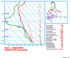
IIRC, forecast soundings for 6/20/11 showed VB for most of the column over eastern Nebraska. The day ended up producing a couple of EF2's and one EF3 in central/eastern Nebraska (m avatar is one of them). It would be interesting to see the forecast soundings vs actual observed soundings for the day because I distinctly remember thinking the day was screwed but ended up being pleasantly surprised. It's possible the forecast soundings were contaminated with bad data because from what I remember the winds backed from roughly 700 mb on up. However, if there was backing in the atmosphere that it would be interesting to find out why it still produced multiple significant tornadoes.
 
IIRC, forecast soundings for 6/20/11 showed VB for most of the column over eastern Nebraska. The day ended up producing a couple of EF2's and one EF3 in central/eastern Nebraska (m avatar is one of them). It would be interesting to see the forecast soundings vs actual observed soundings for the day because I distinctly remember thinking the day was screwed but ended up being pleasantly surprised. It's possible the forecast soundings were contaminated with bad data because from what I remember the winds backed from roughly 700 mb on up. However, if there was backing in the atmosphere that it would be interesting to find out why it still produced multiple significant tornadoes.

I did not look deeply into this particular date, but looking at that sounding it seems like the inflection point happened just above 3km (if the red part of the hodo means 0-3km). Your example could very well support Jeff's point about the importance of the level at which the feature is observed. It would also seems like the critical angle if the storms moved like the predicted hodo showed there is pretty much optimal. Also, many VB profiles I chased in and busted with in the past had weak 3-6km shear due to the sharp backing in the layer, this wasn't the case there.

That doesn't mean that this particular sounding reflected well the environment where the tornadoes occurred but it's the best observation I could find within the warm sector.

OAX_00_obs.gif
 
Back
Top