Thomas Mattek
EF0
Hello! I wrote the following as an answer to a question in the Discord and thought it may be a useful reference/discussion point.
The original question was as follows:
"Is there a parameter or set of parameters that can determine if storms will produce more CG lightning then others? Some storms produce a lot while some just dont. Most of the ones that hit here dont much. Just periodic surprises. But the back side of last nights mcs had several in a row somewhat spaced out"
-Chris(Western WI) at 12:11 AM, August 7th, 2019
I answered as follows, following on the source listed in this old thread on the subject:
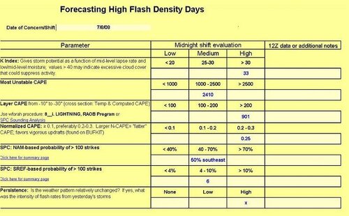
This article, listed on NWS Raleigh's site, on a major lightning event from 2008 sums up some possible parameters, based on the idea that graupel and hail in the mid-levels are important:
Parameter 1)Availability of moisture within the -10 to -30 temperature depth range, usually anticipated by using Precipitable Water(PW)
Parameter 2) -10 to -30 layer CAPE. Higher instability is associated with more graupel and hail formation in this layer.
Parameter 3) Normalized CAPE or NCAPE, looking for above 0.1 or 0.2 to determine how "fat" the CAPE is. Parameter
4) K-Index, based on mid-level laspe rates and moisture.
Parameter 5) Finally, the NAM and SREF have probability indices of 100 or more lightning strikes, detailed in the following paper: 4.3 A physically-based parameter for lightning prediction and its calibration in ensemble forecasts (2005 - Annual2005_lightning)
With regards to parameters, it looks like only N-CAPE is available on current SPC mesoanalysis. If anyone knows of any models that include K-Index and -10 to -30 CAPE that would be appreciated!
There's also the following lightning checklist included:
The original question was as follows:
"Is there a parameter or set of parameters that can determine if storms will produce more CG lightning then others? Some storms produce a lot while some just dont. Most of the ones that hit here dont much. Just periodic surprises. But the back side of last nights mcs had several in a row somewhat spaced out"
-Chris(Western WI) at 12:11 AM, August 7th, 2019
I answered as follows, following on the source listed in this old thread on the subject:
This article, listed on NWS Raleigh's site, on a major lightning event from 2008 sums up some possible parameters, based on the idea that graupel and hail in the mid-levels are important:
Parameter 1)Availability of moisture within the -10 to -30 temperature depth range, usually anticipated by using Precipitable Water(PW)
Parameter 2) -10 to -30 layer CAPE. Higher instability is associated with more graupel and hail formation in this layer.
Parameter 3) Normalized CAPE or NCAPE, looking for above 0.1 or 0.2 to determine how "fat" the CAPE is. Parameter
4) K-Index, based on mid-level laspe rates and moisture.
Parameter 5) Finally, the NAM and SREF have probability indices of 100 or more lightning strikes, detailed in the following paper: 4.3 A physically-based parameter for lightning prediction and its calibration in ensemble forecasts (2005 - Annual2005_lightning)
With regards to parameters, it looks like only N-CAPE is available on current SPC mesoanalysis. If anyone knows of any models that include K-Index and -10 to -30 CAPE that would be appreciated!
There's also the following lightning checklist included: