Mike Hollingshead
While messing around with the site I noticed something about a certain storm feature. It is an inflow band that stretches southeast from the southeast side of an updraft base. I've been aware of the feature for long enough but never stopped to notice just how rare it is. I can only think of two storms I've seen with the feature. Both below:

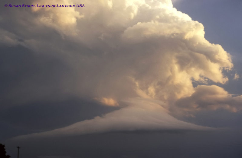
November 12, 2005 in central IA. Image taken just seconds after the tornado hit Woodward IA.

Video capture from July 12, 2004 in central NE from that big 65,000-70,000 foot tall tornadic supercell while it had a large rain-wrapped tornado.
I saw that kind of inflow band form twice on the July 12, 2004 day. Outside those two storms I can't think of or find one other storm I've seen with it.
I looked in the big Storm Talk book(OLD Version....223 page) I have and can't find a specific name for this inflow band(other than calling it an "inflow band"). If a beaver tail has its own name and so does a tail cloud(both inflow features), I think this more rare feature should as well. But, maybe I'm just missing it somewhere and it already has a name more specific than "inflow band".
If no one can find a specific name for this I say stormtrack coins it. This isn't the flanking line just trending down either. The flanking line on both of these curls back sw a bit and this inflow band branches off the updraft base and points se.

This image shows some inflow bands more in the mid-levels of the storm. On the drawings in the book it looks like the cloud tubes are what come off of those as they trail away from the storm. It basically doesn't seem to name those mid-level inflow bands either. But, you can call those mid-level bands and be good to go, I'd think.
I just don't see anything showing the se pointing inflow band attached to the storm base, nor a name for such a thing.
Thoughts? Maybe I'm missing a name.
November 12, 2005 in central IA. Image taken just seconds after the tornado hit Woodward IA.
Video capture from July 12, 2004 in central NE from that big 65,000-70,000 foot tall tornadic supercell while it had a large rain-wrapped tornado.
I saw that kind of inflow band form twice on the July 12, 2004 day. Outside those two storms I can't think of or find one other storm I've seen with it.
I looked in the big Storm Talk book(OLD Version....223 page) I have and can't find a specific name for this inflow band(other than calling it an "inflow band"). If a beaver tail has its own name and so does a tail cloud(both inflow features), I think this more rare feature should as well. But, maybe I'm just missing it somewhere and it already has a name more specific than "inflow band".
If no one can find a specific name for this I say stormtrack coins it. This isn't the flanking line just trending down either. The flanking line on both of these curls back sw a bit and this inflow band branches off the updraft base and points se.
This image shows some inflow bands more in the mid-levels of the storm. On the drawings in the book it looks like the cloud tubes are what come off of those as they trail away from the storm. It basically doesn't seem to name those mid-level inflow bands either. But, you can call those mid-level bands and be good to go, I'd think.
I just don't see anything showing the se pointing inflow band attached to the storm base, nor a name for such a thing.
Thoughts? Maybe I'm missing a name.


") Not from the SE though, it was on the SW end of the storm.
Not from the SE though, it was on the SW end of the storm.