• While Stormtrack has discontinued its hosting of SpotterNetwork support on the forums, keep in mind that support for SpotterNetwork issues is available by emailing [email protected].

Sat 21st May - Question on SPC risk area

Joined
Aug 10, 2009
Messages
57
Location
Godalming, England
Hi all,

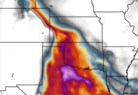
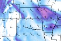
I have a question regarding this Saturday's southern risk area. The SPC have delineated a 'slight' around western OK and TX panhandle, nosing into Kansas. I am aware of the approaching trough to the west and the progressing dryline and the CAPE values do look high in this region. However, I'm struggling to understand why this risk area is not continued any further north, more into Kansas and northeast Colorado. Looking at the latest 12Z NAM for Sun 16-05-22 00z, the bulk shear and CAPE (albeit a thinner tongue) look present in this area too. Is it perhaps something to do with the high 700mb temps which may be accountable for the much higher CIN values?

Any insight much appreciated.

Thanks,
Cammie
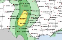
spc.JPG cape.JPG shear.JPG
 
Saturday triple point is forecast in southwest Kansas by most of the latest models (12Z Friday). SPC is likely keying in on the surface feature. Hi-res models also pop a cell over southwest Kansas Saturday afternoon. An upslope surprise would not shock me farther north though, and the SPC has Marginal. Personally I am an outflow boundary hound. If the outflow really ends up southwest Kansas as forecst I would favor the area. Happy and safe chasing!
 
The SPC takes all models into consideration, however their forecasts are usually highly skewed toward the SPC ensemble analysis available on their site (SREF). I don't think they intentionally do this, but it has been a tendency I have noticed for the 2-3 day outlook for the last few years. Sometimes that ensemble is great, but often times it drastically under / over estimates rain and crapvection outputs. Often times it will forecast tons of crapvection when the EML clearly won't let that happen, and sometimes it forecasts the EML is a brick wall when its not.

At least in my experience, the end result is that they tend to favor 'silver bullet' soundings and setups, typically over-casting the southern extent of the forecast, and under-casting the northern half. After a few years of over-casting seemingly perfect setups to the north (not their fault) a decade ago, they have really drawn-down their forecasting of slight, mod, high days in the central and northern plains. That's my anecdotal recollection, so take it for what you will.
 
SPC 1630UTC day 2 outlook said:
THE GREATEST CONCERN FOR POTENTIAL ORGANIZED SEVERE WILL BE ACROSS
THE NRN HIGH PLAINS WHERE HEIGHT FALLS WILL BE FOCUSED...AND ACROSS
THE SRN HIGH PLAINS WHERE MOISTURE/BUOYANCY WILL BE CONSIDERABLY
HIGHER. ADDITIONALLY...SPLIT FLOW REGIME SHOULD ENCOURAGE
HIGH-LEVEL DIFFLUENCE ACROSS THE TX PANHANDLE INTO SWRN KS.

They do have a marginal area there.
 
They do have a marginal area there.
Perhaps I should have worded my question a little more precisely. Rather than asking why 'this risk area is not continued', what I was wanting to better understand why the risk was 'marginal' rather than an extension of the 'slight' given that the moisture return seemed as far north as northeast Colorado. Hence my stab at the high 700mb temps in this area being partly the reason. Just trying to improve my skills at interpreting the model output and was hoping the forum would have some insight into why this differentiation in the risk grade was noted.
 
It's impossible to know exactly why a specific SPC forecaster drew the lines the way they did...it's a human process. However, as I quoted, whoever it was must not have seen much reason to think severe weather was more likely in W KS/E CO. The split flow pattern probably has something to do with that, as it results in rather weak flow over KS/CO.
 
It's impossible to know exactly why a specific SPC forecaster drew the lines the way they did...it's a human process. However, as I quoted, whoever it was must not have seen much reason to think severe weather was more likely in W KS/E CO. The split flow pattern probably has something to do with that, as it results in rather weak flow over KS/CO.

Just noticed you finished your PHD Jeff, Grats! What did you do your dissertation on?

And I second, IMO it looks like they kept marginal based on fairly low POP chances from the ensemble models. High chances of a blue-sky bust in that area based on prior models, but now that we're closer to the event, better return flow and lapse rates are evident, so I think that's why they pushed the risk area further north recently.
 
Back
Top