Outflow Boundaries ?

Joined
Feb 5, 2004
Messages
181
Location
Celina, Ohio
I know what OFB's are but still do not have a clear understanding on where or when to find them in chase planning stratagy.
Are they visable on satellite (ir,vis,wv ?) & what do they look like or only found on radar ?
Are they visible in the morning when you are planning your chase or are they something you look for on the road (WiFi, libraries etc), as the conditions start to develope during the day ?
Thanks for any help and info.

Jon Miller
KT8NDO
[/b]

OFB's (in most cases) can be found on both satellite imagery and radar, it just depends though. Those are usually identified as a "streak" moving away from a decaying thunderstorm complex. You want to look for those before you hit the road and head towards your target. Here's a good example of what an OFB will look like on radar: http://www.theweatherprediction.com/habyhints/146/.

Hope that helps.
 
Yes, they can sometimes be seen on radar and visible satellite imagery. You can also examine surface observations and find them pretty easily (in most cases). Sometimes, however, OFBs dissipate through the day, which can happen in very strong winds (high turbulent mixing) or through normal frontolysis methods (e.g. strong diabatic heating on the cool side of the boundary). Othertimes, like yesterday, you can have persistent development on the cool side of the OFB, which reinforces the cold air outflow on that cool side. In yesterday's case, there was only a 1-2 county wide area between the south and western edge of the OFB and some very cold, very stable air near and east of I35. There were storms that developed on the OFB, but they didn't really have time to mature until they neared I35, after which time they moved over some very cold, stable air (like 68/63). The OFB yesterday wasn't oriented particularly well either, with a general NW-SE orientation, which was about 45 degrees right of the anticipated right-moving supercell motion.
 
When you are looking for an outflow boundary on radar Jon, be sure to look at base reflectivity. Visible satellite is the most reliable way to locate them IMO. Here is a link for high resolution visible satellite with overlayed county lines.
http://weather.cod.edu/analysis/analysis.1kmvis.html
On visible satellite OFB's will be a thin line of clouds moving away from the storms that generated them. It's easiest to see them right after they start. The boundary will start to loose its definition on radar and satellite after a while and then your best bet is to try to find it on a surface chart. When storms start going up later in the afternoon, a lot of times cumulus clouds will build along the OFB which gives away its location again.
 
Outflow boundaries can either be a great thing to chasers...or one that ends some chases. The best outflow boundary setups I have seen are ones where a morning wave rolls through and the severe storms move off in a nice progressive fashion. The departing wave creates some nice prolonged subsidence behind it. The area along and east/north of the outflow boundary begins to rapidly clear out and destabilize. Close temp and dew pt spreads and nicely backed surface winds around the bubble high create a strong area of low level shear/instability. So now the ingredients are there for later tornadic supercells as the next/main wave rolls in. There have been many prolific tornado events over the years that have emenated from this type of setup. More events though have been the end result of cold pool outflows and renewed convection on the cool side of the boundary. This usually is doomsday for chasers...it has put the brakes on quite a few chases for me in the past. These are the kind of the typical issues concerning outflow boundaries I have seen.
 
In the desert, outflow boundaries and the ensuing sand wall they produce show up well on radar (however the most intense radar signature of an outflow boundary I have ever seen happened at 2am in Wichita).

Desert outflow boundaries are a very good sign of future cells developing somewhere nearby. When I see outflows, I consider it a chase night. After the dust storm overtakes the area, 9 times out of 10 there will be good chasing (for lightning) behind the sand wall. There will likely be thunderstorms with lightning, plus the air will be cleaner.

If a chaser sees desert lightning and doesn't want to wait until the sand wall passes, that is ok, but the photographic result will be a wine-colored sky as in:

During sandstorm

Once the sand wall passes through a city or desert, clear air results, however rains will often be torrential. If there is a place to shoot, a good result can come of it:

During heavy rain

Outflows boundaries are a very good sign of storm possibility. When I see them spreading out on radar I know that there will be lightning to chase sometime during the night.
 
ddc1.png


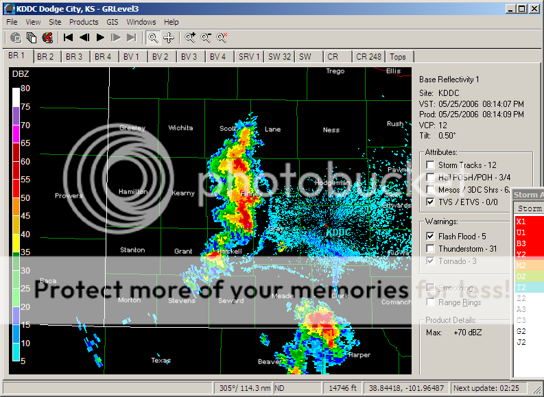
Noticed this interesting feature on DDC's radar, happening attm. 4 boundaries about to intersect each other....
 
Back
Top