On the Continuum of Walls and Shelves

Jeremy Perez

Supporter
Joined
Aug 31, 2008
Messages
342
Location
Flagstaff, Arizona, USA
In 2010 after my first Great Plains chase, I spent a lot of time going through my photos and working to improve my understanding of storm structure. For one of those exercises, I attempted to diagram the Bowdle supercell. There was a lot of excellent feedback and discussion on all the structure in that beautiful, terrible, amazing storm.

Each new supercell I chase broadens my appreciation for all the ingredients and dynamics that make each one unique and awesome. I enjoy recapping each one and visualizing what was happening, so I’ve been keen to diagram some more recent storms.

What I especially wanted to work on were transition points in space or time where a shelf cloud is merging or morphing into a wall cloud/tail cloud and vice-versa. A lot of times it’s pretty clear what’s what. But because the storm and its environment don’t care about taxonomy, there are plenty of cases where things ride along a diffuse spectrum. To me, it’s educational to watch these things unfold and look for transitions where one thing becomes another, and what that means for the fluid movement and interaction of near-storm air masses.

So, here is a batch of a few more (images link to larger versions). I’m definitely interested in any thoughts on the interpretation, or if anyone has any they’d like to throw in, or re-diagram what I’ve posted.

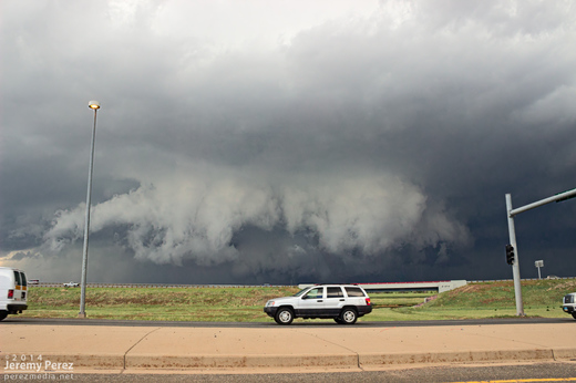
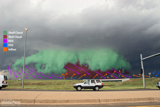
Denver Supercell - May 21, 2014
While this storm was still strengthening over Denver Metro and headed toward the airport, it had a very compact RFD shelf that I wanted to call a wall cloud at first glance. But the RFD appears to be responsible for lifting this prominent feature out ahead of the base while the true wall clouds spins away behind. Mike Olbinski’s time lapse nicely demonstrates the dynamics (See the 6:24 segment of the video).


Goshen County Supercell - May 20, 2014
This was a view that to me, beautifully demonstrates the source of a weak wall cloud’s formation as the forward flank’s rain foot intrudes into the updraft, drastically lowering the condensation level in that area. How much of the foreground lowering would technically be considered a wall cloud vs. RFD shelf was questionable to me.


Newkirk, Oklahoma Supercell - May 19, 2013
This is an example of a transition point where the RFD is smearing a weak wall cloud into a shelf cloud. At least that’s how it seems to me. You can see that the foreground lowering is ‘pointing’ toward the forward flank, and benefiting from lowered condensation as it rises into the base. But now it’s being hurried and lifted on its way by the RFD gust front (which it ‘points’ away from). It seems to be in a place between both ‘definitions’ and both dynamic conditions.


Very nice work, Jeremy. Clearly you have spent a lot of time thinking about this, and you probably have a more polished analysis than most others on this topic.

I personally don't worry much about the distinction between shelf clouds and wall clouds. Generally it's pretty easy for me to determine if a lowered cloud base is an indication that a tornado may be imminent or if it's just outflow. Certainly there are "in-between" or hybrid cases like you demonstrated, but when they're so close together, it doesn't always make a practical difference (i.e., you'd look towards the same region for a tornado if one may occur).

Part of it is perspective or angle. In your Denver shot, it looks like you are due south or due east of the region of interest. Move a few miles laterally and you'd get to see a different perspective of that RFD/wall cloud object and you'd be able to better determine which is which.

It also helps to have video rather than just still photography. Shelf clouds can roll (along a horizontal axis), but they don't rotate (along a vertical axis). Wall clouds don't always rotate, but if you see a lowering that is rotating about a vertical axis, then it's a wall cloud. You can't always tell that from a still photo.
 
I'll have to try this with the May 11 storm this year from near Kinsley. It was the first time I had seen a tornado form on the northeastern side of the storm, with the cold front gusting out the southern part of the storm helping create the brief tornado. I didn't get pics though, just video.
 
I personally don't worry much about the distinction between shelf clouds and wall clouds. Generally it's pretty easy for me to determine if a lowered cloud base is an indication that a tornado may be imminent or if it's just outflow. Certainly there are "in-between" or hybrid cases like you demonstrated, but when they're so close together, it doesn't always make a practical difference
Yeah, this is a really good point, Jeff. I guess my interest is not really to identify wall vs. shelf as a tornadogenesis factor. It’s actually more where you’re headed — to demonstrate the low value the terms have in identifying what’s going on with a storm without adding a lot more descriptive information.

I’m glad you mentioned the value of video. I was diagramming these based on first-hand experience beyond that one point in time. So I have my recollection, plus additional photos and video I haven’t processed yet that informed how I interpreted those. Like with Olbinski’s video of the Denver supercell. It turned out he and I were in the same general location, east of the storm. I was trapped in my car though, heading north, trying to find a way off the stupid toll road. I did get more handheld out-the-window photos with additional perspective along the way.

(Series where I had been trying to identify a possible area of circulation.)


I also have some video of the Goshen County supercell. I’m not sure why I haven’t processed/edited that yet—I’ve kind of fallen in love with the motion on that one when I was previewing it. Now I’m motivated to hop on that over the next couple days…

Marcus, is it this shot you are talking about? (assuming this is a frame grab?)
http://thetxwxchaser.smugmug.com/We...al-KS/41112174_B8S6Zv#!i=3276801366&k=ZLwpk7W
 
Let me just say that this is the discourse that only this site provides. While SS structure is anything but easy to understand (and I'm at the low end of the knowledge spectrum) this helps those of us that love to learn from Stormtrack.
 
Jeremy, I totally love what you've put together here!! Awesome work. It inspired me to take another look at a very confusing chase from June 6th this year in western Kansas. This storm just east of Syracuse put down a couple brief tornadoes. I had a really difficult time getting a read on the storm throughout most of its lifecycle.

h0UtDbX.jpg

This shows our position/view direction relative to the storm. We followed from behind for the duration of the chase.


0pa55aH.gif

There was the pronounced lowering at the time of the radar scan, but I had a very difficult time reading the FFD, RFD, inflow, etc. This area would produce a tornado within the next 30 minutes or so.

vPQJ8mn.gif

Wallcloud? Shelf cloud? I am definitely curious about other's interpretations here. Here's a wider view for context, if that helps with identification.
 
Keep in mind one really easy way to distinguish between wall clouds and shelf clouds:

-Air parcels entering shelf clouds ride up over outflow and so shelf clouds point away from the storm
-Air parcels entering wall clouds are coming from the FFD and thus wall clouds point towards it (not quite opposite to the direction a shelf cloud would point, but the span of possible angles includes 180 degrees)

The angle from which you're viewing makes it a little hard to tell for sure, but from the wide view it kind of looks like that lowering is pointing more or less away from the precip core, and thus would be a shelf cloud. I don't suppose there's any meteorological reason a lowering of clouds of that size can't be accepting air parcels BOTH from outside the storm and from inside the storm, thus making it a hybrid. For example, in your first GIF, the left edge of that lowering looks pretty meaty with a rather flat edge and could be classified as a wall cloud if there's any rotation in it. That's another good feature to look for - did you see any appreciable rotation in the feature? How much time is spanned in those animations? It might be too short a time to tell. There is definitely some interesting motion in portions of the lowering, but much of what I see looks to be along a sloped ascent corroborating it being a shelf cloud (there is some downward motion or shedding of cloud material at the edges, though, which is interesting).

Can you supply more metadata about those images? Also, how far away from that feature do you think you are?
 
Last edited by a moderator:
Thanks for the analysis, Jeff! I would estimated we were about 4 miles WSW of the feature at the time of the animations, so definitely a tricky observing angle. The feature certainly does appear to be sloping away from the precip core, and that coupled with the inflow rising up and over it from the south had me thinking shelf cloud. However, that meaty, flat northern end that you noted definitely did have rotation (not violent, but definitely present). Not only that, but we could also see white columns of (presumably) hail fog being ingested directly up from ground level and into this "wall cloud." Couple those two things with that downward cloud shedding along the bottom lip of the feature, and that sums up my confusion.

(The animations feature roughly 8 and 16 seconds of feature evolution, respectively).

Once the storm became tornadic, there were definitely more conventional features, and this was our first time observing a tornado from the west and looking into the RFD cut, so that was quite a treat. But prior to and after the brief tornadoes, I was very much at a loss for what the storm was up to.
 
Craig and Stephen, thanks for the comments on the diagrams and discussion! And Stephen, thanks for posting that example. That kind of messy structure behind the storm leaves me kind of stumped a sometimes too. The downward, right-to-left motion on the outer edge of that shelf is interesting and makes me wonder if the air riding over the shelf is getting cooled rapidly, or perhaps it's mixing with a second layer of RFD. I'm with you and Jeff about the left side of the lowering in your first image—that it could be a wall cloud...would you mind if I diagrammed one of those and posted it here? Just for some thoughts.
 
Actually, I think I can draw this out as just an outline diagram. So in this one, the smaller orange arrows would depict inflow riding into the notch and feeding the possible wall cloud. Then closer to the viewer perspective, the small purple arrows would be the RFD gust front that's lifting up the shelf cloud feature. Then the larger orange arrows would be surrounding air being lifted and condensing over the gust front. Then perhaps to account for the sinking motion, maybe there is another gust front from the line of storms running west from your main cell, and this is mixing and interacting with warmer air that's otherwise rising and forming the shelf and so you have some sinking motion too.

I'm not sure how far off base I am with that.

StephenHenryStormDiagram.jpg
 
Unless I'm mistaken I thought the shelf cloud was always well ahead of the wall cloud and RFD. In most severe thunderstorms the ffd does most of the damage not the rfd which might cause damage in tornadic storms. Am I right for the typical severe eastern coast US supercell?, while storms farther "west" have two shelf clouds?
 
Unless I'm mistaken I thought the shelf cloud was always well ahead of the wall cloud and RFD.

Often, not always, depending on what you mean by well ahead. RFD will bow a wall cloud into a shelf cloud/gust front, while the new cycle and wall cloud forms east of the old one. In this case you could have a shelf cloud behind the wall cloud.

In a typical cycle the RFD gust front's shelf transitions right into a wall cloud:

65358_10100523377649011_490317280_n.jpg


Differentiating the transition point between wall and shelf can be difficult, but I don't dwell too much on this. I think the important thing is to get your bearing on the structure as a whole and recognize where the the RFD gust front and clear slot are, and what portions are being driven by outflow and which are being driven by inflow.

In most severe thunderstorms the ffd does most of the damage not the rfd which might cause damage in tornadic storms. Am I right for the typical severe eastern coast US supercell?, while storms farther "west" have two shelf clouds?

RFD, not FFD, is most often the stronger and potentially more damaging downdraft in supercells. You'll notice on many tornado damage surveys that they sometimes have trouble telling the RFD damage from the tornado damage.

I'm not sure what you mean by storms further west having two shelf clouds. You could see multiple gust fronts anywhere and supercells on the east coast are not necessarily different than ones further west. You can get sculpted LP supercells on the east coast. They're rare, but they happen. It's just a matter of getting the thermodynamics and shear in place to support them.
 
Back
Top