Observations from June 17, 2010

Joined
May 1, 2004
Messages
3,417
Location
Springfield, IL
While chasing its easy to miss stuff as your fixated on one thing. I'm always amazed at how I pull new stuff out of my video each time I watch it, including things I never knew were there at the time. I got a lot out of the dissecting the Bowdle supercell, and Bowdle tornado threads, and thought it might be a good idea to do the same with the June 17, 2010 storms. It helps a lot labeling things and trying to visualize the processes when reviewing pictures and video, and others might get something out of this or have their own observations or critiques.

The following are frame grabs from my video of the Albert Lea area storms:


...and here's a level 2 radar animation with GPS track:


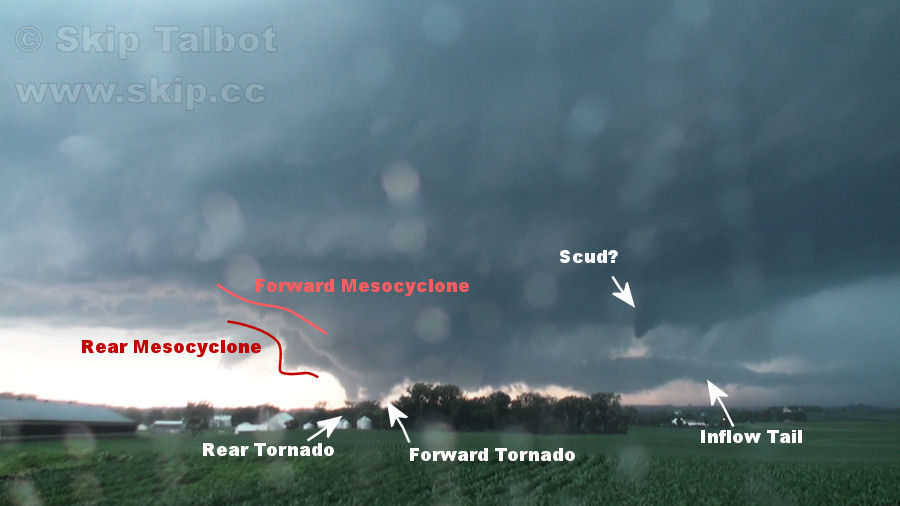
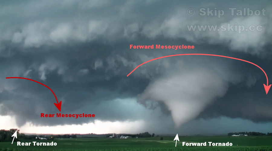
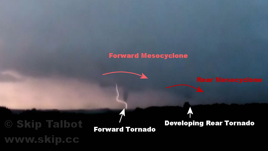
What first struck me about this storm were the dueling mesocyclones. I'm used to thinking of a cyclical supercell as having one meso occlude while the new one is spinning up and you can get some overlap there with simultaneous tornadoes before the old circulation finally dies and the new one takes over. This storm, however, was maintaining both mesos at the same time, each putting down multiple tornadoes:
100617label01.jpg

100617doubletor.jpg

100617label02.jpg


A great example of missing things is the middle image. Danny Neal and I thought the two areas of condensation were suction vortices of the same tornado on the rear mesocyclone. However, after watching video from other angles and looking more closely, we discovered that this was actually a separate tornado under the forward mesocyclone. Looking head on here the two appear right next to each other but there is probably almost a mile between them.
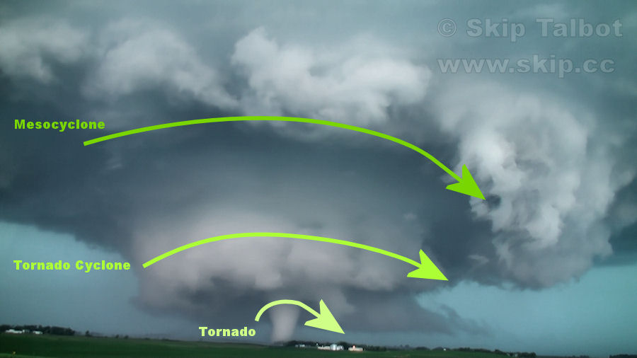

100617label03.jpg


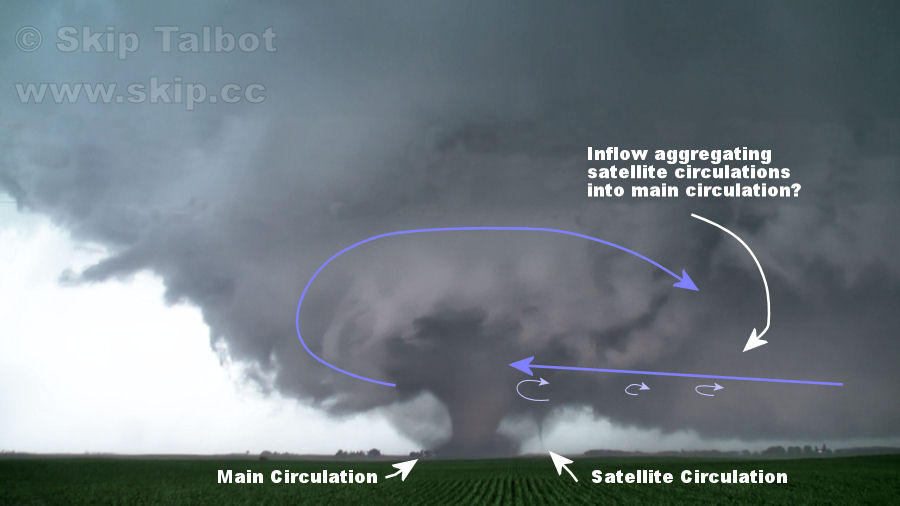
I just love the structure in this shot. Never had I seen three levels of increasingly tight rotation so plainly demonstrated.

100617label04.jpg


Here's an attempt to make sense of some of the satellite tornadoes we were seeing. We saw several funnels on that forward inflow portion of the storm. The circulations appeared to orbit the main circulation before being ingested. It makes me wonder if there was a ton of vorticity feeding into this storm, spinning up satellites, and then aggregating into the main circulation.
100617antisat01.jpg

100617antisat02.jpg


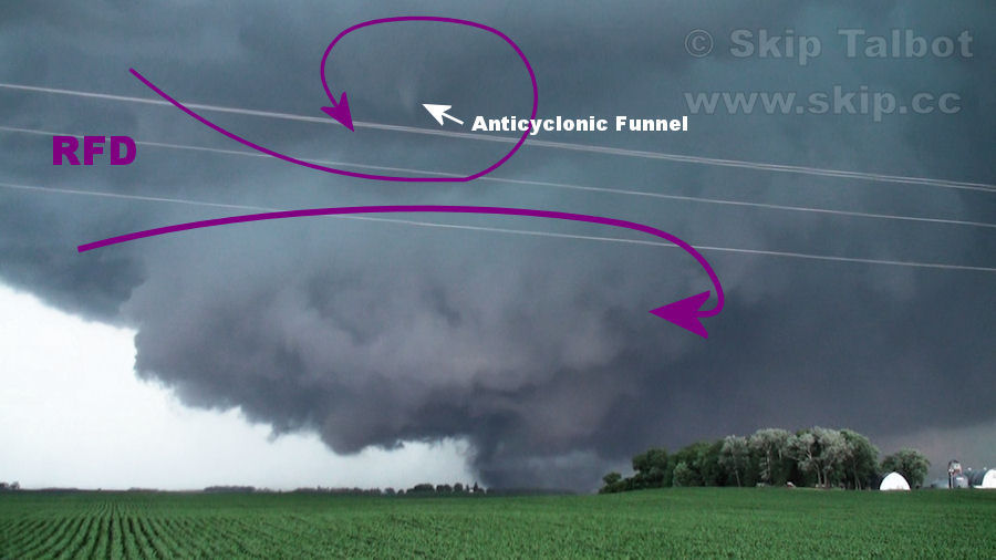
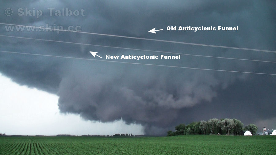
This is something I completely missed until a youtuber brought it to my attention. It appears that the RFD is acting like a mini bow echo here with the southern book-end-vortex portion of the gust front kicking up anticyclonic funnels. In the video you can see a couple of them spin up in rapid succession. What's even more interesting is Adam Lucio's view of the storm at this time. At right about the moment these funnels are occurring, Adam was hit by very strong, rapidly shifting winds. His position lines up pretty closely these funnels as he was between me and the tornado at the time of this frame grab. Despite how high these funnels were, it makes me wonder if we actually had an anticyclonic tornado and that Adam found himself inside of it.

100617ring.jpg


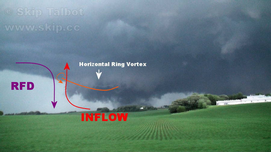
Here's another really neat feature I didn't see until after reviewing the video. You can see it much better in Adam's video as he was closer, but there is a horizontal ring vortex here, circling the wall cloud and descending. I drew some lines here to try and visualize the winds that might be responsible, speculating its generated by horizontal vorticity between descending and rising air.

Anyway, I found it fascinating going over these details and thought I'd share it here and see if there were any other insights, alternate ideas, or if people had their observations from this day.
 
Interesting observations there...I will toss in my input.

I too was amazed by the dueling mesocyclones, Im no expert but I always thought that given the strong surface flow [backed winds 20-25kts in some places] it acted as a barrier to hold the RFD back as it appears to have not cut all the way through here.

100617label02.jpg


About those anti cyclonic funnels, that is indeed interesting because during the incident you mention above I even say in my video "I think that was a satellite vorticy that went over us" There indeed was a very brief yet intense gust of wind in the opposite direction of the main flow that was quickly followed by calm winds and even a couple of falling pieces of debris.

You can see how hard the crop is being blown over.

201006171844088.jpg


and then the falling debris which can be better seen on video in Minnesota Mayhem [shameful DVD plug I know!]

2010061718440810.jpg


copyof2010061718440811.jpg


The stills arent great because A] I wasn't holding the camera still and B] My PC struggles with 1080HD video.

About the Horizontal Ring Vortex which I dubbed a Horizontal Vorticy in my video, I had a real great view of that and was an interesting thing to see as it descended rapidly from the meso it seemed. I have never seen anything like that before.

201006171844087.jpg


One thing I will add to the discussion is what can be described as intense little dust devils spinning up and dancing around the main tornado after it had moved east of Conger, these do not show up well in the stills but do show up very well in the video [especially in HD] if you can take your eye off the main tornado.

201006171844086.jpg


I see something new everytime I watch video from this day, its fascinating just how much was going on.
 
Nice insight Skip and Adam - I love analysis threads like this. I don't have too much to add to analysis, but we saw something fairly unique towards the end of the storm's life cycle, as we were late to the party.

When everything kind of congealed and merged into one big ugly wreck of a storm, there were possibly 3 tornadoes on the ground within minutes of each other (Tornado #1 was a long exposure, and the others were video grabs), all in different parts of the storm. Our position was on 30 (I believe) heading East into Hayfield, just in front of Tornado #1.

5225148496_dd75583f40_z.jpg


Tornado #1:
4710206907_a448b61f51.jpg


Tornado #2 (verified by NWS survey):
5225151102_c2045e5af9.jpg


Trunk to the left:
5224556223_ccd945b2ba.jpg
 
There were many perturbations that stood out to me after viewing my video from that day. In the first photo, the storm was behaving as expected, with a new tornado forming as the old meso was being occluded.

In the second - fourth photographs, when viewing the tornado in its multiple vortex stage, some of the subvortices were incredibly apparent, appearing quite quintessentially, true to their natural (20-60 seconds) brevity, but I didn't pay as close attention to them until I reviewed the video in slower motion. Finally, there were several satellite tornadoes. Besides a similar photo that Skip posted, I figured I would throw in the one (last photo) that occurred about ten minutes before Skip caught the one that he posted.
 

Attachments

  • MNST1.jpg
    MNST1.jpg
    6.7 KB · Views: 83
  • MNST2.jpg
    MNST2.jpg
    5.8 KB · Views: 77
  • MNST3.jpg
    MNST3.jpg
    6.5 KB · Views: 70
  • MNST4.jpg
    MNST4.jpg
    7.7 KB · Views: 86
  • MNST5.jpg
    MNST5.jpg
    9.8 KB · Views: 69
Skip and Adam...these things are great! I like how this is diagnosed. You know, it's making observations like this that helped create the 1979 Lemon and Doswell paper on tornadogenesis and mesocyclone structure. I'm a big fan of the observational storm chasing, however I don't have enough background or time to spend to fully engage myself in it. Keep it up!

I find it really interesting as to how a storm that looks like that on radar could put out such wild structure.
 
I find it really interesting as to how a storm that looks like that on radar could put out such wild structure.

Here's the radar at the time of the three tiered, upside down wedding cake:
100617kmpx2337.jpg


Part of the problem is that KMPX is quite a ways away from the storm. The other big problem, I'm guessing, is due to attenuation from the radar having to look through an entire line of storms to see this supercell. I imagine if the radar was just south of the supercell, it would look much more like a classic hook echo with a more well defined rain free region.

For the most part, the storms did have a very sloppy appearance that day on radar. They look like the type of storms you get when you have weak lapse rates and high precipitable water values... very rainy, sloppy looking storms, and to a certain extent they were. You had to be just south or southeast of the circulations to get a good view of them, otherwise you were in the rain.
 
I would attempt to diagram as well, but since Adam, Skip, and I all chased together (2 cars) it would be redundant. However, this storm was by far BY FAR the most amazing thing I have ever seen. We sat watching the meso(s) approach for 23 minutes in one spot and saw numerous tornadogenesis occur. Each time I watch my video, I see something new and will watch the same clip over and over and over. I believe on 3 or 4 different occasions in the 2 hours we chased this storm, there were satellite tornadoes and/or two different circulations on the ground at the same time. I think one of the most amazing things I noted was a cyclonic wall cloud with a tornado and immediately to the south of that an anticyclonic wall cloud with funnels. As Skip has shown above. Even the secondary supercell that developed over Albert Lea had multiple tornadoes on the ground at the same time. The environment in S.MN was insane on June 17th. Thankfully no towns were hit down there, but unfortunately there was a fatality and damage to farms....

Putting tornadoes aside, that supercell won't easily be beat in my chasing career.
 
Any of you guys have morning model data and soundings from the day? It kills me to see the extremely photogenic tornadoes down there, even though I did bag a tornado farther north (beginning of the Almora EF4) but it was no where near as photogenic or cyclic as the storms farther south. Had I known southern MN was going to turn out the way it did, I definitely would have opted for that area. But IIRC, morning data showed veering surface winds in southern MN and favored northwest MN as a good target. I'm not dissapointed with my day up towards Wadena, but the terrain and storms were no where near as favorable for chasing as southern MN.

EDIT: I also find it ironic that hardly Minnesota chasers were on the storms in southern Minnesota...
 
Any of you guys have morning model data and soundings from the day?

I posted some of that data in my chase synopsis. We picked that target based on a look at morning observations, in conjunction with model output data for later that afternoon. I remember exiting the vehicle in NW Iowa to grab some lunch and almost having my chase partner's door slam into a parking lot light due to the strong SE surface gusts during the late morning.
 
i love the analysis that you guys keep posting on the big days we had last spring/summer! it's a great learning tool, especially for those of us that are still fairly new to looking at a storm and picking out all the different parts of the structure of a supercell. i was in southern minnesota that day, and it's a day i'll never forget, and wonder when i will see something as amazing as i did that day! there was talk about the horizontal funnel that was seen on one of the tornadic circulations at one point. i also have video of that from fairly close. the video is not as great a quality as some of the still pics and other video taken by others (i'm getting a new hd camcorder for next chase season!), but if you skip ahead to about 6:15-6:20 on my video i posted on youtube, you can see the horizontal circulation clearly! sorry for the random yelling of excitement:D

http://www.youtube.com/watch?v=nxqXRyXcCRg
 
Being my first chase where I've seen strong pre-frontal trough action, I've been particularly interested in that aspect of the post-chase analysis. I've had some time to look at the models for this day in greater depth and here are some thoughts on the 22z storm environment. These images are all from the 22z RUC and have been tweaked for clarity in IDV:

700mb temps were close to 12deg for much of the Midwest, and while that is getting close to the limit in June, it didn't prove to be a limiting factor at all. Note the insane helicity, but relatively weaker CAPE near Wadena, where the other EF-4 hit. This image has 2500+ SBCAPE on top of 200+ SRH, showing that these parameters were favorable for very destructive tornadoes across a large area in S MN and N IA:

5225217519_c2cdc7106e_b.jpg


So how did the pre-frontal trough figure in? This next image has surface theta-e showing the surface front clearly on the MN/Dakotas border, but the filtered reflectivity (cut off below 30DBZ) shows initiation in S MN/N IA more than 100 miles off the surface cold front. However, you'll notice a 'wall' where the surface wind vectors abruptly shift which indicates the pre-frontal trough:

5225217527_b41322fd86_b.jpg


If EHI was favorable, and capping wasn't an issue, why did that line only form in a certain area on the pre-frontal trough, and what caused this trough? A little bit of conjecture, but:

5225217525_a0164f3270_b.jpg


825mb relative humidity shows very deep moisture in a band that happens to coincide with the pre-frontal trough, and with the initial convection. 700mb winds (red barbs) along with 700mb theta-e (not pictured) indicate an increase in speed and some sort of mid-level front, which probably caused the surface trough below. Note that the 700mb wind maxes coincide with the pre-frontal trough from the first image.

This is my best guess at some of the factors in play on this day, so please correct me if anything seems wrong. There are still lots of unanswered questions in my mind.
 
Skip, In the first part of my video there is a good view of your 1st pic you posted with the begening of the front meso and the rear meso and the first few tornadoes they produce. Hope this angle of view helps with your study. Let me know what you think


Last edited by a moderator:
Hey guys,
Here is a video screen grab (sorry for the poor quality) of a storm from June 17 that went through just west of the Twin Cities near Winsted, MN and Buffalo, MN (it eventually produced a couple weak tornadoes).

Anyhow, I've labeled the storm features on this image. However, I'm not 100% sure if they are labeled correctly and would appreciate any insight (as I'm always trying to learn). Also, there is a 'occluded meso' off to the left of these features but is not included in this screen grab. The image itself is from just south of the storm looking pretty much straight north.

You can also see my video where I took the screen grab from by going to the link below (the screen grab is from ~1:50 mark in the video):
http://www.majorleaguestorms.com/2010-storm-videos/june-17-2010-buffalo-mn-tornado/

Here is the labeled screen grab:
screengrab2.jpg


Thanks for any help in advance!
 
Last edited by a moderator:
Back
Top