Number of Supercells to increase due to global warming

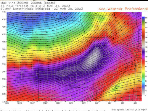
If there is anyone not familiar with the correlation between a strong jet and strong tornadoes, here is the ECMWF forecast of the polar front jet stream winds at 4pm CDT tomorrow. The left front and right rear quadrants of the jet core are the most potent.

The left front quad will affect tornado potential in the Midwest tomorrow afternoon and early evening. The max winds are forecast to be a ripping 172 mph. Screen Shot 2023-03-30 at 7.22.53 PM.png
 
Well calling a Doctor a “name” to refute his claims wouldn’t be effective, so that was a good move on your part.

But admitting you haven’t read his actual paper is telling.
 
I never meant to start any arguments .. and wasn't even thinking politics when I posted.
I will be making no further comments here.
Also I'm asking:
Can a Mod or Admin please DELETE my post.
 
High Risk declared

On climate

The third pole

I hate vines

GOES-U
 
Last edited:
Just a heads up--an FYI for today.

I found this interesting:

The approach allows a more correct representation of turbulence effects in weather, climate and air pollution models. "This is particularly important for understanding and predicting weather and climate projections in mountainous and polar regions, since similarity theory routinely fails there. These regions are particularly vulnerable and already experiencing unprecedented warming under the global change, and a therefore a precise description of further developments is vital," emphasizes Ivana Stiperski.

Climate on other worlds:

Tornadoes
 
Last edited:
The eastern half of the CONUS is located perfectly for severe weather. Here, warm and humid air from the Gulf of Mexico meets cold air from Canada, leading to the development of low pressure systems. These lows generate strong winds in the low- and mid-levels and can act as a source of lift due to convergence near the low. Since these low pressure areas are entirely located above land, friction slows down the surface winds and also orients its direction more towards the low compared to the winds at higher levels. In addition to all of this, there often is a dryline which can enhance convergence rates since the horizontal density gradient (due to the difference in moisture content) leads to a circulation that is similar to a see breeze.

I do not expect any of these things to change due to climate change, except the cold air from Canada. The extensive snow cover there results in a very cold air mass due to reflection of sunlight and radiative cooling. If the extent of this snow cover becomes smaller then that cold air mass will become warmer, leading to less powerful low pressure systems and hence weaker low-and midlevels winds and possibly weaker convergence too. This is similar to the reason why there is not much tornado activity during the summer months. Some possible consequences:
- lower prevalence of (strong) tornadoes
- tornado season becomes shorter
- northeastward shift of area with most tornado activity

There can be other changes too, such as the prevalence or position of high pressure systems but I'm not able to tell if and how these will change. Latent heat release in clouds could increase if the moisture content of air becomes higher due to increased evaporation. And maybe there are other things that I did not think of and that can change the story.
 
While you do say a lot of things that sound like weather - those are not really based in science. There’s far more involved in low pressure formation than “cold snow-covered air meeting hot humid air.“ I highly recommend the AMS book “A Thinking Person’s Guide to Climate Change” in order to help out a bit.
 
Thanks for your reply. Of course, there are other major factors that come into play with low pressure area formation such as inertial forces (centrifugal force, Coriolis force) due to conservation of momentum and viscous forces (ground friction, energy cascade in turbulent boundary layer flow). However, these only act on preexisting wind fields. Ultimately, those wind fields are generated solely due to horizontal pressure gradient forces and gravity. Examples are a cold air mass next to a warm air mass or a bubble of hot air surrounded by cold air.

In the first case, the warm air will start to flow on top of the cold air, while the cold air will undercut the warm air mass. In the second case, if heat is suddenly supplied to a pocket of air then its pressure will rise so that it is now higher than the immediate surrounding air. The pressure gradient force then moves the air outward to equalize the pressure difference with the environment. The vertical pressure gradient force is now the same as in the initial situation, but the counteracting gravitational force is lower due to the reduced air density after the expansion of the air parcel. So in this case horizontal pressure gradient forces cause an imbalance between the vertical pressure gradient force and gravity such that the parcel is accelerated upwards. Of course, in reality we don't have perfect air masses or air parcels, but rather all cases in between. The atmospheric equations of motion take this fully into account, however.

These initial horizontal pressure gradients can arise due to differences in solar heating (latitude, time of year, albedo due to snow cover, cloud cover, soil type, dust), sensible heat flux, latent heat flux (dry vs wet soil, ocean), net longwave radiation flux (surface emissivity, greenhouse gases) etc. Of course, preexisting wind fields have a major direct or indirect influence on these processes. However, if we started with an atmosphere at rest then within a few months we would have the weather systems as they are now, while if we started with an atmosphere in motion but no solar heating etc. then this atmosphere would come to rest eventually. So thats why I mainly took into account the primary causes of atmospheric motion.

An observational or modelling study would be required to say anything conclusive about a change in tornado occurrence. However, a difficulty is that motions at the scale of a tornado are not yet resolved in current climate models (even not in current operational models). Alternatively, one could look at the frequency of favorable atmospheric environments for tornadoes as a proxy. And if such a study proves me wrong, I would be the first person to admit it :).

Just to be clear, the above post was by no means meant to play down any devastating effects of climate change. Thanks for the recommended book, looks interesting!
 
There is no reason to believe that global warming is going to cause worsening violent tornadoes.

Let's step through the evidence.

Classic climate change theory says the poles will warm more quickly than the tropics. That is exactly what has happened. As we all know from Synoptic Meteorology 101, when there is less temperature contrast between north and south, there is less of a jet stream (of course, I'm simplifying). A lesser jet stream means fewer opportunities for violent tornadoes.

So, with that hypothesis, let's look at the data. Here is a graph of violent (F-4/5) tornadoes since 1950.
View attachment 23544
The numbers for 2021 = 3 and '22 = 4. EF-5's have become vanishingly rare as it has been ten years since the last.

While this would seem to be enough to prove that violent tornadoes will not increase due to global warming, let's see if we can find more evidence.

We know that 75% of tornado damage is caused by violent storms. So, if violent storms are decreasing, then we would expect normalized damage to decrease. And, that is what has occurred. Here is the peer-reviewed data.
View attachment 23545

So, we know that earth's warmer atmosphere = fewer violent tornadoes. It is a positive aspect to a warmer climate.

Mike is correct here. I''ve taken the NOAA/SPC tornado database since
1950 and crunched the numbers myself.

Since 1950 for the U.S.:
1) F/EF3+ tornadoes show a distinct downward trend.
2) Killer tornadoes shows a distinct downward trend.
3) Tornado fatatlies shows a distinct down trend.
4) EF1+ tornado total count trend is basically flat since 1950.

If you just take F/EF4-5 tornadoes, there is is distinct downward
trend as well. One may ask, perhaps how we rate tornadoes have
changed over time? It has. But even accounting for this, a downward
trend in F/EF4-5 tornadoes still exists, whether you start in 1950
(start of official period of record), 1975 (when the Fujita Scale was
introduced), or 2007 (when the Enhanced Fujita Scale was introduced).

About 70% of all fatatlies and damage from U.S. tornadoes come from
EF3+, which are 7% of all tors. So it's the EF3+ ones that we really
need to be the most concerned about here.

The above really isn't subject to debate. These are hard statistics
and matters of fact taken from the official NOAA/SPC database.

For all tornadoes since 1950, yes, the annual totals are up, but that
can be almost completely explained by our much better detection and
documentation of weak, short-lived tornadoes (F0/EF0) just in the last 25
years alone. One thing that has become glaringly apparent, tornadoes
associated with squall lines (QLCS) are *far* more common than previously
thought (most are EF0).

Below are some individual tornado statistics not likely reported by the
mainstream. The thing to keep in mind what does not get reported (or
omitted) from the mainstream news can be just as or more important than
what does. The adage, "there are two sides to each story (or more to
the story)" applies here.

- 2018 had only 10 tornado fatalities, the lowest annual total since
1950. 2016 had only 18, the third lowest annual total.

- No violent (EF4/5) tornadoes occurred in 2018. This the first time
this has occurred.

- 2 violent (EF4/5) tornadoes occurred in 2017. This is tied for the
3nd lowest on record. 2006, 2009, and 2016 also had 2 and only
2005 had less (1).

- 12 tornadoes EF3 occurred in 2018 and 15 tornadoes EF3+ occurred in
2017. These are the lowest counts since 1987.

- 886 tornadoes in 2014 was the lowest annual count since 1989 when
865 were recorded. Adjusted for inflation such a low count is more
of an extreme than it appears to be.

- 2012, 2013, 2014, and 2016 all had under 1000 tornadoes per year.
Every year 1990-2011 except 2002 had over 1000.

- Record low monthly tornado counts for February, March, May, July,
and August, September, and November have all occurred since 2009
going back to 1985.

- From 5/16/17 to 3/19/18 (306 days), no EF3 tornado occurred in the
U.S. This is by far the longest EF3+ gap since reliable records
began in 1950.

- From 5/17/17 to 2/23/18 (283 days), there were no tornado
fatalities in the U.S. This is the longest stretch on record.

- In 2018, only 3 EF3+ tornadoes occurred through 5/31. This is the
least amount so late into a year in modern records.

- OK went through the end of April 2018 without a single tornado, the
latest on record for the state. KS had no tornadoes through the
end of April this year as well, the latest on record since 1985 and
only the third time since 1950.

- The U.S. went 672 days w/o a violent tornado April 2017 to March
2019. This is the longest period on record.

- It has been almost 10 years since the last U.S. EF5 tornado. This is
the longest period on record. The previous record was set from 1999
to 2007.

- The record for most consecutive days with at least one tornado in
the CONUS is 70 from 4/23/1991 to 7/1/1991.

- May 2020 only had 126 tornadoes. This is the third lowest monthly
count in modern times. The 2 EF2+ tornadoes for the month is a
record low.

- June 2020 had no EF2+ tornadoes which is the lowest on record for
this month.

- No tornadoes were recorded in the ICT WFO CWA in 2020.

- May 2021 had no EF3+ tornadoes. Not since 1974 had this occurred.

- August 2022 only had 33 tornadoes, this tied the record for the
lowest for this month.

- For significant tor outbreaks in 2021, none occurred in April,
May, and June (prime season) for only the second time on record.
First time was 2018 and that year, there were no significant
outbreaks at all, which was the first time on record for a year.

"Significant" is defined as at least (from Grazulis):
- 1 EF4 or EF5
- 4 EF2
- 2 EF3
- 2 EF2 and 1 EF3

2021 significant outbreaks:
3/25 4 EF2 4 EF3 1 EF4
7/29 4 EF2 1 EF3
9/1 3 EF2 1 EF3
12/10 15 EF2 6 EF3 2 EF4

- The Idabel OK EF3 tornado on 11/4/22 ended the second longest stretch
(1259 days) in OK w/o an F3/EF3 or higher.

- The 11/4/2022 outbreak had two EF4 tornadoes from two discrete
supercells. This is the first time this has happened since
11/17/2013.
 
While you do say a lot of things that sound like weather - those are not really based in science. There’s far more involved in low pressure formation than “cold snow-covered air meeting hot humid air.“ I highly recommend the AMS book “A Thinking Person’s Guide to Climate Change” in order to help out a bit.

One important detail. It is likely that the mere presence of more
supercells does not guarantee more tornadoes or even more strong/violent
tors when you look at all the details. It is a long and very narrow
road to go from a supercell to a *tornadic* supercell, and even longer
when going from a brief spin-up to a long-tracked monster.

I've thought about this over time. The conditions to get a tornado, esp.
strong/violent ones, are *very* specific, and a lot more precarious than
I think some realize.

How many supercells occur in the U.S. a year? A lot more that we realize
if you count every CB that has at least a small echo on radar that rotates
even in a broad, weak sense? What percentage these actually produce a
tornado? 10-15%? And how many actually produce strong/violent tornadoes?
Even less.

So these are some of the smaller-scale factors I thought of that can make
or break tornadogenesis. Can model simulations in a warmer globe account for
all of these?

* storm mode in general (line, cluster, isolated)
* supercell mode (LP, CL, or HP)
* mean height of LFC
* intensity of a sfc low - warm sector
- how much cloudiness
- extent of backing of winds at sfc and veering winds aloft
- any oddities in shear profile, like VBV
- strength of forcing
- capping inversions
- lapse rates - low-level and mid-level
- mean storm areal coverage
- near surface T/Td spreads

I am just thinking that *any* one of the parameters above is off, it
can make all the difference in an event with a lot of weak, short-lived
tornadoes, and a lot of strong/violent, long-tracked tornadoes. LFCs just
a bit too high? Lapse rates just a bit too weak (column too moist)? Storm
coverage just a bit too crowded? The list is long! And how often does
everything look "perfect" for a major tornado outbreak on paper, and it
does not materialize?

And more supercells could just mean more weak, short-lived tornadoes.
The EF3+ tornadoes do by far the most damage and cost of life. Those
could not increase, or go down (which current data shows they are down
over the decades in the U.S.).

And this has been mentioned already, in a warmer globe, baroclinicity lessens N-S
simply due to more warming at the poles than the equator overall. This in turn
would mean less intensity of ET lows worldwide, and a significant percentage
of the worst tornadoes outbreaks are associated with moderate or stronger
ET lows or 500 troughs. So this mean less wind shear associated with these
storms, and shear is what it is really all about if you want significant
tornadoes. I know you have the Planfield IL (1990) and Jarrell TX (1997)
cases, but those are much more the exception than the rule. You can have all
the CAPE in the world, like what year round exists in the tropics now, but
that does necessarily not mean more tornadoes overall, esp significant ones.
 
Back
Top