gdlewen
EF4
Introduction. I started watching this situation a couple of days ago, and it has developed along lines that pushed away from "possible dryline" to the (less-interesting) "stationary front". I am hoping for some discussion of the general ideas presented here; especially if you know of odd dry line orientations, etc.
Anyway.... There is a strong moisture discontinuity along the KS-OK border in tomorrow afternoon's models that I have convinced myself is not a dry line. I would love to be proven wrong.
WPC forecast analysis shows it as it as a stationary front (no figure given), but when you look at the spatial distribution of moisture along the KS-OK border, it's hard not to think "dry line". I am using specific humidity because it is one of the few quantities that are conservative and can be used as an air mass tracer.

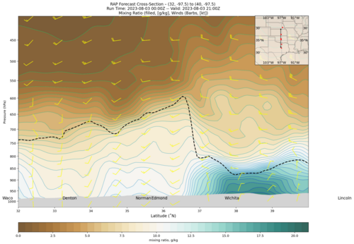
It's even harder not to think "dry line" looking at a S-N cross-section across the KS-OK border:

One more bit of information, though, seems to debunk the "dryline theory": the potential temperature distribution superimposed on a cross section of the Petterssen Frontogenesis (PFG) function depicted below. (I am using the 2D method for PFG applied to each layer, and fully realize that, in this application, the PFG is most-properly calculated using a 3D formulation.) However, using "Layer-wise 2D PFG" in cross-sections seems to be a familiar "cheat" in the literature. Plus I'm just looking for some idea if there is a frontal surface aloft, sloping S-to-N across the moisture discontinuity. It sure looks like it.

So: Stationary Front? or Dryline? Again--if any of you have experience with oddball dry line orientations I'd love to get some feedback...plus dates, of course. (I have other graphics; for instance, moisture convergence etc. But, "Enough is enough.")
Anyway.... There is a strong moisture discontinuity along the KS-OK border in tomorrow afternoon's models that I have convinced myself is not a dry line. I would love to be proven wrong.
WPC forecast analysis shows it as it as a stationary front (no figure given), but when you look at the spatial distribution of moisture along the KS-OK border, it's hard not to think "dry line". I am using specific humidity because it is one of the few quantities that are conservative and can be used as an air mass tracer.
It's even harder not to think "dry line" looking at a S-N cross-section across the KS-OK border:
One more bit of information, though, seems to debunk the "dryline theory": the potential temperature distribution superimposed on a cross section of the Petterssen Frontogenesis (PFG) function depicted below. (I am using the 2D method for PFG applied to each layer, and fully realize that, in this application, the PFG is most-properly calculated using a 3D formulation.) However, using "Layer-wise 2D PFG" in cross-sections seems to be a familiar "cheat" in the literature. Plus I'm just looking for some idea if there is a frontal surface aloft, sloping S-to-N across the moisture discontinuity. It sure looks like it.
So: Stationary Front? or Dryline? Again--if any of you have experience with oddball dry line orientations I'd love to get some feedback...plus dates, of course. (I have other graphics; for instance, moisture convergence etc. But, "Enough is enough.")
Attachments
Last edited:
