Non-Supercell Tornadoes (Waterspouts/Landspouts)

Bobby Prentice

The October 26, 2006, southwest Kansas landspout tornado outbreak has sparked a lot of discussion. I thought it would be appropriate to begin a thread that provided a review and further insight into the non-supercell tornado (landspout/waterspout) forecast problem.

A landspout is a form of non-supercell tornado occurring with a parent cloud in its growth stage (e.g., towering cumulus) and with its vorticity originating in the atmospheric boundary layer. Waterspouts are another form of non-supercell tornado and basically form the same way.

ORGANIZING STAGE

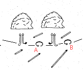
Landspouts/waterspouts form along convergent, horizontal wind shear boundaries where cumuliform clouds are rapidly growing. Small atmospheric boundary layer vortices called misocyclones form and propagate along these boundaries (particuarly near boundary intersections).

scherung1.gif


The "[FONT=Verdana, Arial, Helvetica, sans-serif]0-3km CAPE (J/kg) and Sfc Vorticity" graphic from the SPC Hourly Mesoanalysis [/FONT]web page provides perhaps the best weather chart to see this enviroment in real time. This page is generally best because it includes national mesonet surface data (from MesoWest) and RUC model data in its analysis. Here is an example from the 10/26/2006 southwest Kansas landspout outbreak:

0-3km[FONT=Verdana, Arial, Helvetica, sans-serif] CAPE (J/kg) and Sfc Vorticity, 10/26/2006, 21z[/FONT]

MATURE STAGE

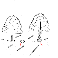
A landspout/waterspout may form when a convective updraft becomes co-located with one of these misocyclones. The landspout/waterspout circulation developes from the ground upward as the pre-existing vertical vorticity is streched by the updraft. The horizontal diameter of the misocyclones decreases which increases the rotational velocity of ciruclation. This is process is analogous to a figure skater which spins faster and faster as she brings her arms in closer to her body. The strongest rotation remains below the cloud base in the atmospheric boundary layer.

scherung2.gif


Here is a picture of one of the October 26, 2006 southwest Kansas landspouts from Jon Davies excellent case study page at: http://members.cox.net/jondavies6/102606swks/102606swks.htm

102606nonsprcl_pic_mu_anno.jpg


WSR-88D radar loops and 1 km rapid-scan visible satellite loops are necessary for further interrogation and detecting fine scale details in growth and development.

DISSIPATION STAGE

Precipitation induces a downdraft within the vortex. The landspout/waterspout weakens and its vertical exent is reduced as the cumuliform cloud's updraft weakens.

One of the biggest problems warning forecasters experience is the landspout/waterspout has often dissipated when a precipitation echo has reached the surface. However, is one landspout/waterspout has developed the mesoscale environment is often primed for more to form.

FORMATION CLUES

Favorable radar indicators for non-supercell (landspout/waterspout) tornado development include:

- Boundaries exhibiting strong horizontal
wind shear
- Collision points of two or more boundaries (example)
- Boundaries possissing wave-like inflections (scalloped appearance) suggesting circulations
- Rapidly developing storms near low-level circulations
- Region along a boundary possessing high radar dBz reflectivity values in clear air return (signature of strong convergence)
- Boundaries with high radar specturm width values (which imply strong wind shear)

RADAR DETECTION PROBLEMS

-
Landspouts/waterspouts may form before any precipitation echo has developed.
- The small horizontal extent of the circulation limits the detectable range.
- The strongest rotation is confined to low levels (
the atmospheric boundary layer). Thus, radar horizon problems prevent us from seeing boundaries beyond about 50-60 miles from the radar and misocyclones beyond about 20-30 miles.

samp1.gif

 
I think we need to continue to determine if these tornadoes really were non-supercell... My hunch is that some were non-supercell tornadoes, while others were tornadoes associated with a mesocyclone (making them supercell tornadoes). I don't have time to explain much now, so I'll copy what I wrote in the DISC thread regarding this:


It is very important to determine, however, if yesterday's tornadoes really were associated with low-topped supercells with (relatively) deep, persistent mesocyclones (a little redundant, since supercells, by definition, contain deep, persistent mesocyclones). I haven't looked at radar data from the event, but there's the possibility that these were nonmesocyclone tornadoes caused by intense stretching of ambient vertical vorticity not associated with deep, persistent mesocyclones. This is a very important distinction to make! Many landspout tornadoes on the Front Range are caused by strong low-level vertical acceleration associated with building TCu stretching vertical vorticity in or near a misocyclone. A "cold-core event" typically refers to situations in which convective cells "feed off" the ambient vertical vorticity along a boundary and develop relatively persistent, deep mesocyclones. On the 3-20-06 case, the cell near Putnam indeed did develop a deep, persistent mesocyclone, along with other supercell "features" (RFD clear slot, etc, as noted earlier). I suppose much of this comes down to the depth and duration of the rotation in the cell. Were they really tornadoes associated with supercells / mesocyclones, or were they more shallow, landspout-ish tornadoes? It's not entirely a clear-cut distinction in the first place, and I haven't looked at any radar data to determine either way.
 
Convective Weather Maps - USA still displays the model maps, due to a long lasting data interruption at the NCEP servers I get the data from. Check out forecast hours +33-39. It appears that (at least in this model) the SREH and low level shear are outside the area of this storm, while good deep layer shear partially overlaps it. The extreme gradient and convergence could well produce a spout-type tornado while overall conditions (also the sounding in Jon Davies page) would not exclude tornadoes. My current reasoning is that under such circumstances vortex-stretching would be the main mechanism, but the tornado actually can get stronger when strong horizontal vorticity from the surroundings is tilted into it.... but this a statement that can hardly be proven, only supported if vertical wind profiles were obtained near the tornado.

Oscar
 
If a distinction is made between supercell and non-supercell tornado then you have to draw a line somewhere. In my opinion, Stumpf, Ladue, Davies and company are drawing the line in the wrong place. They are counting way too many tornadoes as non-supercell, ones that are produced by storms with supercell characteristics RFDs, precipitation hooks and tilted mesocyclones or deep misocyclones. Call me crazy, but a tornado in association with a mesocyclone is a supercell tornado regardless of whatever theoretical tornadogenesis process you think produced the tornado.

http://members.cox.net/jondavies6/102606swks/102606swks.htm
Davies Wrote:
“It is true that some of the cells on radar or viewed by chasers developed supercell characteristics with shallow mesocyclones and visual RFDs. This may have been related to increaseed horizontal shear with east winds north of the boundaries, as well as strong deep-layer shear in the general environment. But the rapid development of tornadoes was largely confined to boundaries, and, combined with the sounding characteristics above that would strongly enhance low-level stretching, suggest that this was an event dominated by non-mesocyclone processes.â€￾


Can it be proven that Mulvane (6/12/04) didn’t form as a direct result of stretching of ambient vertical vorticity? The Mulvane supercell only produced tornadoes when it was interacting with boundaries, maybe the mesocyclone wasn’t what caused the tornado to form, maybe it was also an "event dominated by non-mesocyclone processes".

Scott C.
Warning: Questioning PhDs can be hazardous to you heath!;)
 
I think it's important to consider that tornadoes can form in a spectrum of environmental settings... from purely non-supercell processes (the "landspout" like along the DCVZ) and from purely supercell processes (like 3 May 1999). Tornadoes can indeed form through non-supercell processes (now, more appropriately non-mesocyclone processes in the literature) yet still be integrated with a supercell thunderstorm. So, "non-supercell processes" is probably less correct than "non-mesocyclone processes". But where do you draw the line between non-mesocyclone and mesocyclone induced tornadogenesis? I don't think that's very straightforward. I think you can most certainly have both processes going on with the same storm, and even a combination of the processes going on with the same storm (a spectrum). 26 October was an excellent case of tornadogenesis occurring through what I think was a spectrum between pure the pure non-mesocyclone "black box" and mesocyclone "black box". Volumetric interrogation of 88D data most certainly supports supercell structure on 26 October at times... especially at 2200 UTC to the west of Bloom, KS. This contrast-enhanced tornado image was two minutes before the 2200 UTC Dodge City volume scan on 26 October. There is an incredible vault structure with the reflectivity "blob" or "finger" protruding down the southwest side of the 30,000 ft tall storm. Rather fascinating stuff.
 
Last edited by a moderator:
I can say some of the tornadoes on Oct.26 were definitely landspouts (non-supercell tornadoes), but 2 were definitely not. I witnessed mesocylone formation, followed by an rfd clear-slot, followed by tornado formation as the meso occluded, and the tornado dissipated as the meso got completely occluded and died.

I witnessed this process 2 solid times from the back-side of the storm with a perfect vantage point, and I was able to tell at least 5 minutes in advance where the tornado was going to form by watching the cycle of the parent mesocyclone. If that is a normal non-supercell tornado life-cycle then I've been watching non-supercell tornadoes all these years and have yet to see an actual supercell tornado.

The single video still/picture of one of the many tornadoes used by Bobby Prentice in his argument does not account for all the tornadoes on that day. I could use the analogy that because one of the tornadoes on the El Reno supercell on April 24, 2006 was a landspout, then that must conclude that all the tornadoes from that storm were landspouts. I know that is an extreme example and is not a cold-core example, but it does relate to this situation regarding a picture.

The tornado on March 20, 2006 was not a landspout, but it formed under very similar circumstances; along a completely occluded warm-front boundary with a small region of limited low-level CAPE with very steep lapse-rates and incredible vorticity advection with height. That storm barely showed up on radars, and the Norman NWS office only put a severe warning up when I reported a rapidly rotating wall-cloud. They put a tornado warning out for the storm after it had produced its only tornado. Anyone there (I know Jeff S. was there) would have seen the great storm structure of the storm before it produced the tornado, small, but classic structure.
 
For what it's worth, I think one of the reasons some folks have been reluctrant to consider the storms on this day as supercellular is the lack of shear sampled by the DDC sounding that evening. The proximity to the event would make you want to think it might be representative - but only found 9 knots of 0-6 km shear - which isn't supposed to be enough to support supercell structures. Next, for a storm to be a supercell - the rotation has to be persistent. Well, how long is persistent? One volume scan can't be enough, but what about 2, or 3? Fuzzy definitions here, and as pointed out above, the size of the circulation can vary, and may not be well sampled. I'm surprised nobody has run the algorithms for this day or checked to see if there are clearly continuous deep storm-scale rotation (I don't have time to volunteer right now) colocated with the tornado events.

Scott I think is certainly correct that we know storms interact with boundaries, and this idea of stretching spin along boundaries may not have any bias toward the organization of the updraft over the boundary that is doing the stretching. A supercell is just more likely to keep an updraft around and will have stronger updrafts lower to the ground. As far as the extent that visual characteristics around the tornado can be used to ascertain the storm organization - I would note that the mesocyclone scale is much larger than the tornado cyclone - typically by about a factor of 10 - so features such as striations on the updraft are probably a better indication of a mesocyclone than seeing a clear slot - which is smaller in scale and suggests that sinking air is wrapping around the tornado cyclone (which may or may not have been forced by a mesocyclone related process).

It is thought that a mesocyclone is capable of generating sufficient low-level rotation to produce a tornado with no help from a boundary - but most in fact do need 'help' in order to produce a tornado, so the idea that boundaries are only for non-supercell tornadoes certainly isn't true - though you'll be hard pressed to get a tornado out of a non-supercell storm without a boundary. Unfortunately, we don't have a means to easily distinguish between supercell storms that 'needed' a boundary to produce a tornado from those that don't.

So, if a nonsupercell storm develops an updraft over a boundary, and that rotation is lifted and stretched, this tornado cyclone would be present at mid-levels. So does this then make it a mesocyclone and subsequently a supercell? I don't think so, I want to see the whole updraft rotating, not just a column within it. You could perhaps look for other signatures of larger scale rotation such as a persistent BWER (not just transient echo overhang) to scale the updraft diameter and compare it with the rotation scale. I'm a believer though that if you aren't looking at the whole updraft, you need a radar interpretation to know if you have a supercell or not.
 
<snip>
The single video still/picture of one of the many tornadoes used by Bobby Prentice in his argument does not account for all the tornadoes on that day.<snip>

I didn't begin this thread with the intention of "proving" that the 10/26/2006 southwest Kansas tornadoes were caused solely by non-supercell (i.e., landspout) processes. But rather as a way of educating ST members about non-supercell processes. I was hoping others would include photos, diagrams, etc. to further enhance the learning process. As others have stated, storms exist in a spectrum and tornado formation mechanisms are often not clear cut.

FWIW...I've performed a cursory review of the 10/26/2006 KDDC WSR-88D data (0.5 degree reflectivity, SR-velocity, meso, and TVS) and believe non-supercell processes did dominate this outbreak. The storms developed in a zipper-like fashion east and southeast along two boundaries in a classic landspout pattern. No TVS's were detected, but the meso algorithm did occasionally trip (particularly 15-25 miles southwest of KDDC). This along with chaser accounts suggest there might have been a transient mini-supercell or two in there. Part of the problem with radar classification of these events is, did persistent updraft rotation exist before the tornado or was the radar simply detecting the landspout rotation as it extended above the boundary layer?
 
No TVS's were detected, but the meso algorithm did occasionally trip (particularly 15-25 miles southwest of KDDC).

I'm not an expert on the TVS algorithm, but I do know that I don't trust it much given high False Alarm Rate and relatively low Prob of Detection. Of course, it depends on the settings of the algorithm that DDC used/used (TTS, etc), but I really wouldn't consider TVS much in cases where the circulations are small and short-lived... In cases such as the event last week (and other cold-core events), I suspect that the temporal and vertical continuity constraints of the TVS algorithm may not be met, regardless of how strong the circulation is. Given the small size of the supercells that I've seen in "cold-core" events the past couple of years, I think it would really help to have a mobile Doppler radar on an event such as the most recent one.
 
With respect to the amount of deep layer shear present for this event... I think it's worth noting that cold core tornado events often occur within a tight gradient in the 6km shear values directly downstream of mid-level lows. (Sep 21 2006 and Nov 27 2005 are two other classic examples of this). Deep shear in these events in a given location "falls off" rapidly with time as the mid-level low moves overhead and the mid-level jet shifts eastward. Because the Oct 26 2006 event began a couple hours before balloon launch and as much as 20 miles south of DDC (and thus nearer the mid-level jet axis), I'd be willing to bet the 6km shear was a little healthier than was sampled by the DDC RAOB. The tight gradient in shear adds a whole lot of doubt as to what it really was, though.
 
If a distinction is made between supercell and non-supercell tornado then you have to draw a line somewhere. In my opinion, Stumpf, Ladue, Davies and company are drawing the line in the wrong place. They are counting way too many tornadoes as non-supercell, ones that are produced by storms with supercell characteristics RFDs, precipitation hooks and tilted mesocyclones or deep misocyclones.
I said this? I'm not a proponent of drawing distinct lines between mesocyclone and non-mesocyclone tornado processes. As others have already stated, there is a spectrum of processes. Many have noted that some supercell-related tornadoes sometime get a "kick" from some stretching of vertical vorticity while interacting with a boundary (outflow boundary, or an RFD or FFD boundary from the parent supercell). And some seemingly "pure" landspout tornadoes have been observed (by me) to develop clear slots and a mid-level circulation during the muture portions of their lifetimes.

Simon Brewer said:
I could use the analogy that because one of the tornadoes on the El Reno supercell on April 24, 2006 was a landspout, then that must conclude that all the tornadoes from that storm were landspouts.
Interesting that you bring up this case, which I had first hand experience with from in-situ observation and subsequent post-mortem radar and damage survey analysis (using WSR-88D and TDWR data). One could conclude only by looking at pictures of the anticyclonic tornado that it was a landspout - it bore a resemblance to many of the non-mesocyclone tornadoes that form on the Colorado High Plains - dusty vortex with multiple endwalls, etc. But the amount of vortex condensation and dust does not have any bearing on the classification of the vortex mechanism. This is a function of the amount of ambient debris and humidity, coupled with the strength of the pressure drop in the vortex.

Nonetheless, I strayed from my original point regarding the anticyclonic tornado on the El Reno event, and other supercells. Many of these anticyclonic tornadoes are associated with the right bookend of a rear-flank downdraft circulation that produces two counter-rotating vortices in the updraft. I submit that the anti-cyclonic tornado pairs in supercells may be more connected to a deep circulation and may be closer to the mesocyclone-tornado side of the spectrum - or meso-anticyclone tornado.

Jeff Snyder said:
I'm not an expert on the TVS algorithm, but I do know that I don't trust it much given high False Alarm Rate and relatively low Prob of Detection. Of course, it depends on the settings of the algorithm that DDC used/used (TTS, etc)...
I have to comment on this, even though my comment isn't too relevant to the topic. One must remember that the TDA algorithm is designed to detect intense gate-to-gate shears in velocity data. These happen more often than not when there is no tornado. But the algorithm is not "wrong" when it detects a gate-to-gate shear couplet that is non-tornadic (only about 30% of operator analyzed TVSs are associated with tornadoes), and thus it cannot be faulted for giving a false detection in those situations. The TDA (and MDA) are designed to point out rotation signatures and provide guidance to warning decision makers to pay more attention to the storm and analyze the base data and other "inputs" (including non-radar sources) to make their decisions. And, BTW, the PODs are quite high for both the MDA and TDA (compared to their WSR-88D predecessors).

I'm not trying to criticize your comments negatively. I wanted to point out a very common misconception of what these algorithms were designed for. Unfortunately, the TDA, or Tornado Detection Algorithm, is a misnomer. We originally called it the TVS Detection Algorithm, but somehow the name was changed (beyond my control at the time) and it stuck. So many people think the algorithm is designed to "detect tornadoes". It is, in fact, designed to detect TVSs. And displaying TDA detections as little inverted triangles doesn't help the problem! Algorithms are designed as guidance and safety nets for those using the data in real-time to make short-fused decisions (warning mets, chasers, etc). For post-analysis of events when time is plentiful, or for those who aren't making critical short-fused decisions (e.g., watching live radar data from your desk) don't use the TDA and MDA algorithms! Go with a careful base radar data analysis instead.

That being said, it is my opinion that the majority of the tornadoes on 26 Oct were dominated by non-mesocyclone processes along a boundary with a dramatic windshift across it (classic landspout ingredient), but that a few of the storms morphed into low-topped supercell hybrids after moving into the cool side of the boundary.
 
Last edited by a moderator:
I'm not trying to criticize your comments negatively

Greg,

The tone of my post came out more 'sour' than I intended. What I meant to address, but didn't convey very well, was the notion that the lack of a TVS lends anything more than very minor support to the potential conclusion that the tornadoes were not "mesocyclone tornadoes". I should have selected my words a little better, and I didn't mean to offend those who have spent their time and energy to develop and improve the TVS and derivatives. From my experience, the presence of the TVS is a pretty decent indicator of a potential tornado / tornado cyclone, but the lack of a TVS (especially in cases such as this) may not be a good indicator that there is no tornado.
 
From my experience, the presence of the TVS is a pretty decent indicator of a potential tornado / tornado cyclone, but the lack of a TVS (especially in cases such as this) may not be a good indicator that there is no tornado.
Agreed - the TDA algorithm can only do as good as the radar data will allow. But if the vortex cannot be resolved by the radar, then how could a radar algorithm resolve it? And I argue that this is not an algorithm "miss" (lowering POD), but rather a radar miss.

Furthermore, one must add in all the other radar data limitations into the mix (velocity and range dealiasing errors, beam broadening with range, beam height with range, discrete vertical sampling, cone-of-silence, AP, etc., etc.). The TDA is designed to assume that the radar data going in is pristine, and that radar data quality control is to be handled by upstream QC algorithms. Upstream QC to improve base radar data quality benefits all storm algorithms.

The evolution of the MDA and TDA as separate algorithms from the original WSR-88D Mesocyclone and Tornado Algorithm was done to separate the detection of the two scales of vortices in the event of non-mesocyclone tornadoes. The old algorithm would "declare" a TVS if the strength of the mesocyclone reached a certain threshold (and not gate-to-gate shear). In the old algorithm, you couldn't get a TVS detection without a meso detection, thus non-mesocyclone tornadoes were not detected. The current TDA runs independent of the MDA to allow for detection of non-mesocyclone gate-to-gate shear.

FYI - everything I've talked about describes the current state of the algorithms in the WSR-88D, but this was the current state in algorithm development circa 1994 (12 years ago!). There has been a lot of new development since then, as well as reconsideration of how to approach the problem (e.g., LLSD "Rotation Track" techniques, WSR-88D Level I spectral analysis, etc.).
 
Last edited by a moderator:
With respect to the amount of deep layer shear present for this event... I think it's worth noting that cold core tornado events often occur within a tight gradient in the 6km shear values directly downstream of mid-level lows. (Sep 21 2006 and Nov 27 2005 are two other classic examples of this). Deep shear in these events in a given location "falls off" rapidly with time as the mid-level low moves overhead and the mid-level jet shifts eastward. Because the Oct 26 2006 event began a couple hours before balloon launch and as much as 20 miles south of DDC (and thus nearer the mid-level jet axis), I'd be willing to bet the 6km shear was a little healthier than was sampled by the DDC RAOB. The tight gradient in shear adds a whole lot of doubt as to what it really was, though.

Jon Davies created a modified RUC sounding for Minneola, Kansas at 2100 UTC.

102606minneolaKS21ruca_anno.gif


A RUC sounding modified with representative surface observations is likely the best analysis we can create for a storm environment. The RUC analysis is typically better (in time/space) than a RAOB (balloon sounding) because the RUC includes nearly all available real-time weather data in its analysis. The RUC analysis for this event likely would have included nearby ASOS/AWOS, KS DOT mesonet, MesoWest mesonet, KDDC VAD Wind Profiles (VWP), Haviland, KS wind profiler; Granada, CO wind profiler , ACARS, PIREPS, GOES data, etc. This sounding suggests the Minneola, KS area might have supported mini-supercells. However...

The AMS Glossary of Meteorology defines a supercell as "An often dangerous convective storm that consists primarily of a single, quasi-steady rotating updraft, which persists for a period of time much longer than it takes an air parcel to rise from the base of the updraft to its summit (often much longer than 10–20 min)." The only way to directly measure updraft rotation is by observing a mesocyclone which is a Doppler radar signature. I don't know what the meso algorithm settings were on the KDDC WSR-88D, but occasional (transient) meso detections were observed relatively close to the radar (primarily 15-25 miles southwest of the KDDC) . I don't know if these detections were for meso or the lesser correlated 3-D shear/uncorrelated shear. This falls in a the gray-shade area of "was this updraft rotation deep and persistent enough" to call these supercells?

Updraft rotation can be strongly inferred by visual observations of striations or a barber-pole appearance to the updraft. At least a few chasers reported seeing these features.

FWIW...I only mentioned TVS algorithm output for completeness sake. I didn't expect the DDC WSR-88D to detect any from this event.
 
Last edited by a moderator:
Thanks for posting the proximity sounding Bobby. Yeah, assuming that it has a fairly good handle of the kinematics, it is classic in showing a much "breezier" environment than a couple hours later at DDC (00Z RAOB). Then again, it also shows 6km is at about anvil level, which indicates typical supercell threshholds (e.g., thinking "if 30kts or 40kts of 6km shear is available, supercells are possible") may not work very well at all anyway in low-topped supercell events. As you indicate, the wind profile, strong low-level CAPE, and pattern recognition (we have a baroclinic boundary and are in the favored quadrant of an incoming vigorous vort max) are enough to tell us mini-supercells are possible.
 
Back
Top