NEXRAD radar holes

Joined
Dec 4, 2003
Messages
3,411
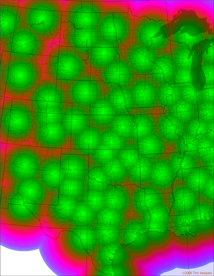
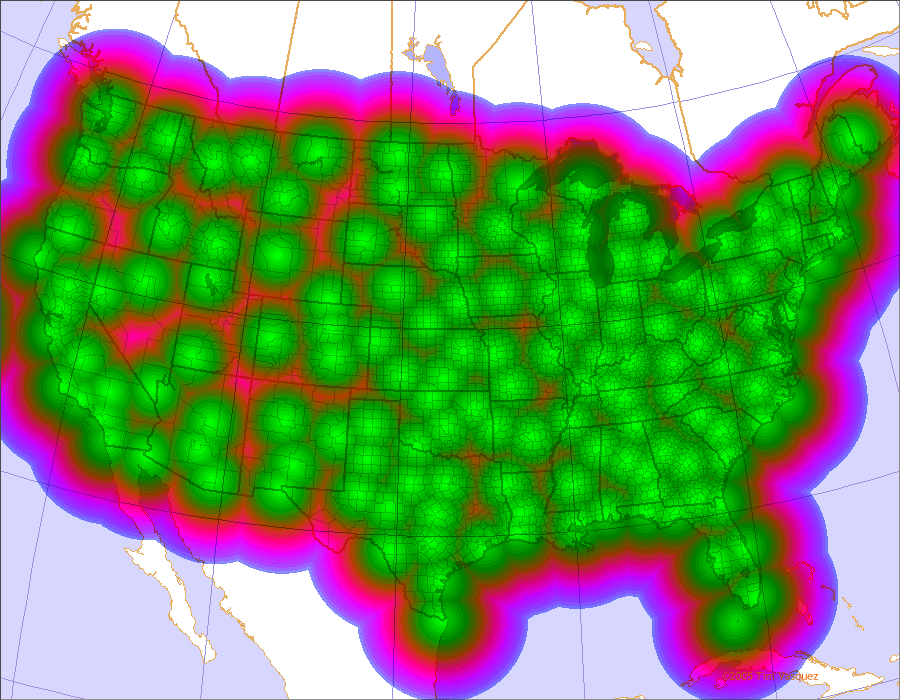
I created these graphics today to get an idea of where the "radar holes" are located and to see the basic coverage of the WSR-88D network. The green falls off at about 100 nm into reds, and the outermost blue color is at 248 nm (the limit of the base data).


Great Plains (click to enlarge)


United States (click to enlarge)

Interesting that northern Missouri (major agricultural belt) has one of the worst radar holes east of the Rockies.

Also see the following for similar maps:
http://www.cimms.ou.edu/~jzhang/radcov.html (Multi-site coverage maps, adjusted for obstructions) http://www.roc.noaa.gov/ssb/queries/siteid/search.asp (Single-site coverage maps, adjusted for obstructions)
http://www.roc.noaa.gov/maps.asp (Basic maps)

Tim
 
Here's a coverage map (at 10,000 feet above site level) of the pre-Nexrad radar network and the proposed Nexrad network, if anyone is interested.

http://print.nap.edu/pdf/NI000004/pdf_image/9.pdf

It's an online book and there is some other interesting stuff in there if you go to the table of contents and skim through out.

A while back, some cities were going to lose their old radar site to other cities, but it was eventually decided that some of these would receive a Nexrad. Evansville, Indiana received theirs early in 2003.

http://print.nap.edu/pdf/NI000004/pdf_image/48.pdf

Comparison of Nexrad location with previous radar network by distance.

http://books.nap.edu/books/NI000004/html/103.html
http://books.nap.edu/books/NI000004/html/104.html
 
I find interesting the ominous hole over Area 51 in Nevada. I wonder if they restrict radars pointing in their direction?
 
WSR-88D

How much does it cost to build and install a WSR-88D?

I ask, because if I was a senator from Missouri or Texas, I'd sure be interested in getting a couple more installations to cover the blind spot in my state. It looks like Missouri could use a doppler somewhere in the Kirksville area. Texas needs another one in a couple of spots.
 
Really interesting map, Tim!

Northern Missouri has a quite a radar gap, as every local station is located in or near the major metropolitan areas (EAX, TOP, OAX, DMX), and the metropolitan areas are spaced at equidistant intervals which happen to coincide with nearly the exact radar limitations. This means that spotters/chasers located in a belt from extreme northeast KS, southeast NE, SW Iowa through northern Missouri serve as virtually the only means for communicating surface level storm behavior. If a storm is located in this zone and I happen to be on it, it makes me more aware of reporting. Typically the NWS seems to do pretty well issuing reports up here, though, all things considered.

Kirksville would be a nice addition for 88D, but it would still leave a gap where the four states come together ... and keep in mind that this region also happens to be one of the most active for tornadic supercells in the state. Lamoni, Iowa may be a good spot to start ... but there would still be a gap on the eastern side of the state.
 
Here's a look at the 125 nautical mile radius from Kirksville, Missouri. Range rings are spaced at 25 nm intervals.

ProposedKirksvilleradar.jpg
 
i've been saying for a while that we need this here!!! i am from keokuk, iowa, and many times i felt like that was too far from the davenport office for good radar. now i'm in hannibal, missouri, and we're on the edge of st louis's office. my real dream would mean that they put in an additional nws office, so i could get a job there... dream on.
 
texas

I also suggest a new radar at Paris, Texas, in Lamar County. That would cover the gap along the Oklahoma border.

Another one at Crockett, Texas, in Houston County would cover the remaining Texas gap.

Anyone have $2,000 to buy a senator?
 
Of course the west is notoriously bad. The terrain just makes it impossible to cover everything. Another bad area is in Vermont. The Burlington radar is located in the Champlain Valley and has a hard time seeing over the Green and Adirondack Mountains.
 
Back
Top