• A friendly and periodic reminder of the rules we use for fostering high SNR and quality conversation and interaction at Stormtrack: Forum rules

    P.S. - Nothing specific happened to prompt this message! No one is in trouble, there are no flame wars in effect, nor any inappropriate conversation ongoing. This is being posted sitewide as a casual refresher.

New map based storm chasing/severe weather web application

Joined
Aug 27, 2009
Messages
197
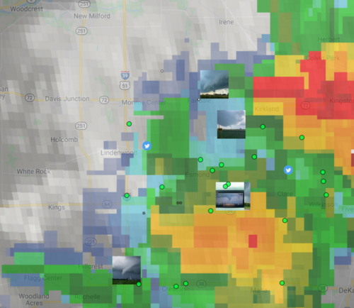
I just published a Beta version of a web application I call StormWindow I have created. It is a map based storm chasing overview web application where you can see position of chasers, photos from storms as they develop, tweets from chasers/tweeters as events are happening - all within the time window of the last 24 hours. The idea of the website is to provide an answer to: "What's going on at the moment (and lately) in terms of storm and storm chasing?"

Please have a look here (at this temporary url): StormWindow by StormChasingUSA.com

Today may not be the most exciting day to look at it but yesterday was pretty cool. I am only "launching" it here on StormTrack in order to get some feedback before I proceed further (please refrain from sharing it further at the moment). I would love some feedback!

The spotter position data has been taken from SpotterNetwork.org. Tweets through the Twitter API and other data from SPC. I have just aggregated all the data into one application. My biggest concern, and what I would like to discuss the most is the issue of privacy. As such, I am launching it without some useful features such as the ability to search for a specific chaser, limit the zoom possibilities, and with names of regular spotters hidden behind initials. Chasers who tweet and geo-located tweets are shown in full.

The position data is being reported to SpotterNetwork through apps such as RadarPro, GRLevelX etc. and SpotterNetwork offers an API (and publicly available data) to retrieve those positions, which is really useful when it comes to follow people on a chase. I assume most, if not all, chasers are aware of this as you can see other spotters in those applications. This is all very good, but it seems like quite a lot of spotters forget, or don't care about, turning their position broadcasting off when they are not chasing.

So, I would love some feedback on the web application itself (user interface, functionalities etc) as well as ideas on how to balance the privacy issues with the useful functionalities of it. Any feedback on the legal part of it as well would be much appreciated.

What do you think?
 

Attachments

  • stormwindow.png
    stormwindow.png
    546.5 KB · Views: 0
Can't access it (blocked on my end because its a '.app' domain instead of one of the normal ones)... but sounds interesting!
 
This is impressive and I second Jeff’s comment about this being a great effort so far.

The Tweets tab has a lot of noise - i.e tweets that have nothing to do with the current weather, even though they may be from chasers. Not sure if there is any reliable way to filter these out and show only those that relate to ongoing storms. Not all of these same tweets appear on the map itself, so I’m wondering if you used some sort of filtering on the map that could also be used on the Tweets tab.

Sorry to pick on a negative, but I assume that’s what you want/need to make improvements, fix bugs, and enhance the site.

As Jeff said, we will need to wait for spring to really experience it and stress-test it.
 
Thanks. Yeah, there is a lot of noise there and especially now off-season. I am using a Google cloud function to filter the images (if it has some sky in it, is is shown) but it is trickier on tweets as the amount of text to analyze is very small.

The tweets on the map actually just show the last tweet from each, I thought it would get too cluttered if I showed every one.

I think the coolest feature is when you can see photos from tornadoes as they are developing and being reported, and you can see how it looked from every angle from where people shot it, as in my screen grab.

What do you think of the privacy issue? Does it strike you as invasive, if I would show the names of each spotter, where there are only initials at the moment?
 
What do you think of the privacy issue? Does it strike you as invasive, if I would show the names of each spotter, where there are only initials at the moment?

I cannot comment from a legal perspective, but I would think that if someone is already making their position publicly known via Twitter and/or the Spotter Network it would be OK…

To your point about chasers forgetting to turn off their position broadcasting when not chasing, is it possible to build enough intelligence into the app such that it would not display location if the person was clearly not chasing - i.e., make it rules-based, such as no radar reflectivity AND not within an SPC Outlook area, etc.?
 
James: I have thought about that as well, around the basis of "How can I tell if a person is actively chasing or not" and "When is someone about to chase?". I thought about having "been moving in the last x hours" be a flag for that but if you are resting idle in a spot for 4 hours waiting for towers to pop-up you are in fact chasing. You may be submitting photos and sharing great info, mainly because you have time to post stuff as well.

Being in an SPC Outlook area could be easier to implement as I may be able to get the GPS-coordinates for those. At least this would rule out people armchair-chasing in NY during an outbreak in Oklahoma. I don't really know where I would set the limit for it though. Everyone in a slight or margnial risk area? It would still cover quite a lot of ground and may miss out on stuff (I think Bennington #2 was just outside of Slight risk / 2% if I am not mistaken?

Looking at radar reflectivity is quite difficult as it is read as png-images, and not data points. It is not impossible but it is just quite difficult and time demanding.

The most important thing I have done, and intend to keep, is to keep the zoom level at a reasonable height. It may limit the information on understanding exactly where another chaser is standing but that information is not that critical.

I am going to write a completely different post on this some other time but my strong advice is: People need to turn off their GPS reporting when they are not chasing!
 
... my strong advice is: People need to turn off their GPS reporting when they are not chasing!
If SpotterNetwork was only intended for Chaser use, that might be good advice. From Spotter Network ...

" The SpotterNetwork brings storm spotters, storm chasers, coordinators and public servants together in a seamless network of information."

Since it is not just for chasers, advising folks to change the way they use it may not be the best approach (at least not without finding out how the other groups use the product).

I am not saying that people should deactivate their GPS-beacon because of my application but because of what I have learned while working with the application. I will bring up a completely new discussion about this later on as well, as this falls outside of what my application actually does.
 
>50mi of movement in the last 6 hours is probably a reasonable heuristic. I think that's what I settled on the last time I considered this exact problem.

Thanks, It seems plausible and would remove the "noise" of people who are reporting location without actually moving but not the ones that are moving around while actually not chasing - which is another section I need to address as well.

What did you when you were faced with this problem?
 
So just curious, how do you aggregate the tweets and photos from chasers? For example, I am a chaser for 17 years now and constantly tweet photos to the NWS but yet I don't show up on your map. Is there a hashtag you search for or do you just find the accounts of known spotters and add them into your search database?
 
The aggregation is actually quite complex. The main portion of tweets are fetched through the twitter accounts that each storm spotter (registered with spotternetwork.org) have mentioned in their bio. A (much) smaller portion of the tweets are tweets with geo tags in the tweet. In order to try to scope out storm chasers as the list to look for storm chasing tweets I have used my own following-list on Twitter (i.e. people I follow on Twitter).

After that I filter out tweets that are not relevant through machine learning. It checks whether the photos are storm related and if the tweets are weather related etc.

Are you a registered storm spotter?
 
I have added another feature that I, myself, have been wanting for a long time: the possibility to browse through the history of weather and check out things like: "How was May 2007 in terms of storms?" or "How many High Risk days have there been in the last 20 years", "How many days with more than 100 tornadoes have there been?" etc. So, I made this: Storms and tornadoes in the 2000s .

What I would love to hear from you here is:
  • What type of information would be interesting to add to the list?
  • Do you know of any cool open data source that would be interesting to plug into and expand the data further?
  • I am thinking of adding graphs or perhaps a full analysis page where one could dig further into the data oneself. But, if I add graphs. What kind of graphs would be interesting to be able to look at from a monthly or yearly perspective?
  • What kind of (additional) filtering of the data would be interesting? I am thinking of things like "Every May the last decade" or "these specific dates every last years"
From any given date, significant or not, what would be interesting to know or read more about that day in terms of storms? I have looked into:
  • YouTube-videos (difficult to pinpoint to a date, but not impossible.)
  • Tweets and tweet photos (likely to come soon)
  • News (haven't found a good, free API for news yet)
Any other feedback on feature, data or information to add would be highly appreciated!

There are some missing features, flaws and bugs at the moment:
  • In terms of outlooks, it (currently) does not look at the max outlook of a given day but the 12Z. So, some days show a lower risk than the maximum of that day. It's on my list to fix.
  • The two lists of significant events on top should obviously be merged
  • The list is limited to 2004/2005 as there are no outlooks or storm reports prior to that (what I have found).
 
Back
Top