Randy Jennings
Supporter
- Joined
- May 18, 2013
- Messages
- 866
One of the most interesting talks at today's TESSA National Storm Conference was by Bobby Prentice of NWS WDTD on Multi-Radar Multi-Sensor (MRMS). MRMS is a real-time system of applications that integrates radar, surface observations, satellite, lightning, and numerical weather prediction data, and utilizes advanced data integration and quality control techniques, in order to generate automated, seamless, national, four dimensional radar mosaics, storm attributes and multi sensor quantitative precipitation estimates at high temporal and spatial resolution. MRMS provides a more accurate and complete display of storms that single-site radars during severe weather outbreaks.
There are several interesting new products:
Azimuthal Shear - Maximum azimuthal shear (rotation divided by diameter; s-1) in the low-level (0–2 km) or mid-level (3–6 km) AGL layer. This product is great for making shear stick out.
Maximum Estimated Size of Hail (MESH) and MESH Tracks - just what it sounds like.
QPE - Radar w/ Gauge Bias Correction: Uses observation data to adjust radar rainfall estimates.
Reflectivity At Lowest Altitude (RALA): Reflectivity at the lowest sampled vertical level that contains data (from multiple radar sites).
Vertically Integrated Ice (VII): Similar to VIL, but the vertical integration is constrained to the thermodynamic layer between -10 and -40°C, which is the graupel/ice growth layer within a thunderstorm.
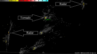
Rotation Tracks: Provides a history of the intensity and spatial coverage of strong storm circulations that may be associated with mesocyclones, tornadoes, and/or damaging winds.Used to determine if a storm has intensified or decayed over time. 0–2-km Azimuthal Shear Tracks have shown enormous utility after events for guidance in immediately directing damage survey ground teams and aircraft, the Red Cross, and other first responders to areas most likely affected by tornadoes. Sample of rotation tracks bellow (compared to storm reports):

There are more products. More info about MRMS can be found at: http://wdtd.noaa.gov/courses/MRMS/index.php .
This data isn't widely available yet. It is free off NOAAPort, but unless you have invested in that, you have to live with a limited set of products on NWS EDD (http://preview.weather.gov/edd/ under "More Layers"). You can also find out more about MRMS at http://mrms.ou.edu and http://wdssii.org/.
There are several interesting new products:
Azimuthal Shear - Maximum azimuthal shear (rotation divided by diameter; s-1) in the low-level (0–2 km) or mid-level (3–6 km) AGL layer. This product is great for making shear stick out.
Maximum Estimated Size of Hail (MESH) and MESH Tracks - just what it sounds like.
QPE - Radar w/ Gauge Bias Correction: Uses observation data to adjust radar rainfall estimates.
Reflectivity At Lowest Altitude (RALA): Reflectivity at the lowest sampled vertical level that contains data (from multiple radar sites).
Vertically Integrated Ice (VII): Similar to VIL, but the vertical integration is constrained to the thermodynamic layer between -10 and -40°C, which is the graupel/ice growth layer within a thunderstorm.
Rotation Tracks: Provides a history of the intensity and spatial coverage of strong storm circulations that may be associated with mesocyclones, tornadoes, and/or damaging winds.Used to determine if a storm has intensified or decayed over time. 0–2-km Azimuthal Shear Tracks have shown enormous utility after events for guidance in immediately directing damage survey ground teams and aircraft, the Red Cross, and other first responders to areas most likely affected by tornadoes. Sample of rotation tracks bellow (compared to storm reports):
There are more products. More info about MRMS can be found at: http://wdtd.noaa.gov/courses/MRMS/index.php .
This data isn't widely available yet. It is free off NOAAPort, but unless you have invested in that, you have to live with a limited set of products on NWS EDD (http://preview.weather.gov/edd/ under "More Layers"). You can also find out more about MRMS at http://mrms.ou.edu and http://wdssii.org/.