May 12th 2005 South Plains Tornado / Hail Decision

Originally posted by Jay McCoy
Thanks. the entire set can be seen at

http://photobucket.com/albums/v652/tornado...dreams/5-12-05/

For some reason they are in backward order. the pics go in reverse time with the end pics being the 1st of the day.

Jay it's interesting that your picture 10 of 34 shows what appears to be a fairly large low hanging funnel directly over hwy 689 to the west as the tornado is in progress just to it's south.

I don't remember how much I saw of that second tornado, but I believe I saw the beginning of it. I was too busy dodging zinging hail stones.
 
Originally posted by Bill Tabor

Jay it's interesting that your picture 10 of 34 shows what appears to be a fairly large low hanging funnel directly over hwy 689 to the west as the tornado is in progress just to it's south.

I don't remember how much I saw of that second tornado, but I believe I saw the beginning of it. I was too busy dodging zinging hail stones.

I can confirm that also. Although I couldn’t tell you if it was rotating or not because, much like you Bill, I was dealing with the hail. I will do some video captures or maybe even a video clip of what is on my video and post them when I get home tonight.
There was the main tornado on the south of the hwy and one (maybe) on the north side also. It was a very chaotic situation. That's why I did not move east.

Mick


Mick
 
Ok I said I would and I did. It just took a while to do it. lol I will try the video later.

Here is one capture. This is looking N.E. on hwy 689 north of the hwy.
20051205.jpg


Mick
 
Interesting. Blurry, but it almost appears there are some weak rotation 'streamers' extending from underneath the main lowered funnel of condensation. Possibly even dust underneath them, but it is very hard to see.
 
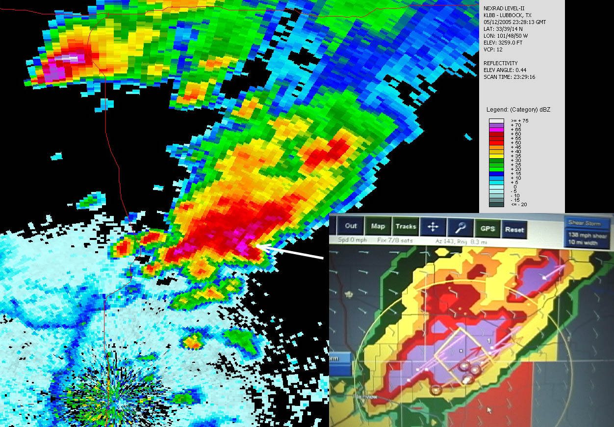
Bill posted some of what I wrote on WX-CHASE, but I figured the actual radar image I was referring to would be helpful. It's posted below.

That tornado did some weird things....things I was not expecting. The parent storm was originally moving ENE, but took more of an east or ESE motion as the core appeared to be surging forward, and the storm consequently became outflow dominant a short time later. I believe the tornado was actually moving SW for a time initially, before swinging south, SE and then E, intensifying rapidly. It was rotating around the parent meso. The Attica tornado on 5/12/04 did the same thing, except it formed on the south side of the meso, before swinging E, NE and then N, crossing hwy 160.

Normally, when you're positioned east of a developing tornado and the parent storm is moving ENE, you're pretty safe and in a great viewing position. But this cyclonic "wobbling" caught me off guard. I was not expecting to have to race this tornado southward as it made a bee line towards my only escape route! Does anyone else have examples of these wobbles? Is there a specific term that describes it?

tnet_radar_compare.jpg
 
Dave posts an exellent example comparing level II data to the Threatnet version. As far as I can tell based on my experience using the Threatnet, the data is actually very low-bandwidth data (needed to get through the narrow XM pipe), and consists of a grid similar to the nationally composited Radar Coded Message (RCM) grid, where

1. The grid is a 2 km cartesian grid of "composite reflectivity", or the maximum reflectivity in a vertical column
2. The grid is a "seven level product" (VIP 0 through 6), with "Level 6" being 55 dBZ or greater
3. Radars in clear air mode are excluded
4. The gridded data are treated as grid points which are then smoothed using a very simple scheme in the software to make filled contours.
5. Includes TVS, meso, storm, and hail algorithm info, but unknown which are NWS algorithms and which are Baron algorithms

CG lightning data also seem to be quantized to a 2 km grid.
 
Tornado Wobbles

In reference to question regarding tornado 'wobbles', my experience leads me to generally assume anywhere under the meso circulation is fair game. Not sure if scientific term for such 'wobbling' exists. Much depends on strength of rotation in meso and overall storm motion / speed. I have been in situations not only where tornado took unexpected turn in direction, but other peripheral funnels or tornadoes formed around edge of meso. I believe, historically, these rotations around the meso explain some of the strange paths of destruction aside from any effects of multi-vortex tornadoes. Additionally, somewhat depends upon position within meso tornado forms; center vs. periphery. I agree that in most cases the tornado follows the general track of parent storm as long as associated meso remains as part of parent storm and meso rotation strength remains at moderate level. However, goes without saying, meso occlusions are no longer bound by parent storm path.
 
That tornado did some weird things....things I was not expecting. The parent storm was originally moving ENE, but took more of an east or ESE motion as the core appeared to be surging forward, and the storm consequently became outflow dominant a short time later. I believe the tornado was actually moving SW for a time initially, before swinging south, SE and then E, intensifying rapidly. It was rotating around the parent meso.

Normally, when you're positioned east of a developing tornado and the parent storm is moving ENE, you're pretty safe and in a great viewing position. But this cyclonic "wobbling" caught me off guard. I was not expecting to have to race this tornado southward as it made a bee line towards my only escape route! Does anyone else have examples of these wobbles? Is there a specific term that describes it?

I agree man, it was kinda crazy wasn't it?! At first I was due east of it as it seemed to "sit" in the field and spin. I got out and ran all the way up into the plowed field to get some shots of it. It wasn't long after that those RFD streamers I mentioned were intensifying and I saw I should already probably be south. I really 'punched it' but by then had no chance of getting south of the torn as it was racing out to the SE and then almost E like you said very quickly. It's amazing how fast it did this really. What a gorgeous tornado, and I got to see it way up close too -LOL.

Interesting your concept of it rotating around the meso though Dave. I really hadn't considered that but seems this would explain it's movement and speed to some degree. For a term....well let's see. It's a rotating meso with tornado attached and when it occurs as a chaser you are simply out of luck. How about "screwed"? That pretty much covers it don't you think?
 
Dave posts an exellent example comparing level II data to the Threatnet version.

Nice summary of Threatnet Greg. I'd say it is pretty accurate. Obviously in comparision the Tnet really is smoothed quite a bit and presents different visual information than the standard level 2. I've had a number of encounters and opportunities this season to experience Tnet compared to what I usually use (Weathertap). It provides benefits, but it also presents problems you have to learn to deal with. For example, early on in the season Gene Moore and I were out chasing the day of the Paris, Tx torn. We had about 3 or 4 supercells nearby. We intercepted a nice one that appeared like it was going to tornado, but then the RFD killed it. The storm near Paris actually appeared smaller and weaker at the time; however it really didn't provide any visual clues that it was a more tornadic storm. Had we been looking at Weathertap perhaps we would have made a different decision. I forget, but I assume Tnet was showing some shear markers on the Paris storm. As I recall they were showing a bit earlier and a bit stronger than out storm a county or two to the south.

You have to learn to use it, and even then such as in the South Plains situation you may not have the detail you need (for safety and retreat in this case). Also the time gap between images appears to be a bit old relative to shown GPS position so you have to learn to move the storm mentally ten to fifteen minutes in the direction of current storm movement and provide yourself with a 'buffer'.

I still love Threatnet, but do wish it wasn't smoothed so much.
 
I noticed the southward "jolt" (as I called it on video) and decided to remain where I was, because the idea of having a tornado in close proximity pass just south of me is more favorable then one passing just north of me (and anyone who drove through the southside of the damage path knows why I feel this way; over a mile south of the actual tornado path a second damage path of RFD winds was clearly evident).

I assumed like most the tornado would move ENE directly at us, and had planned to move a bit north or south to clear its path. I'd had experience with wobbling tornado paths from my May 29, 2004 encounter in south Kansas and, realizing the tornado's track shift was actually taking it further away from us than it had been, felt no danger and held my position to capture video. Had the thing darted left and then right again, I probably would've made a hasty move to try and get east of the parent circulation ASAP; there's no way I would've approached the 5-29-04 tornadoes near dusk the way I did South Plains.
 
Thanks for the Tnet tips Bill. I just bought mine this summer so I have not had the chance to use it yet. I will keep those tips in mind when I do get to use it.

I still love Threatnet, but do wish it wasn't smoothed so much.

You would think they would throw that option in to the software. Then again like someone said earlier you need small amounts of data to flow through the XM flow.

It makes me wonder if the data/image comes smoothed already or if the software on the client computer uses GDI+ or DirectX class calls to smooth it. You would think a pre-smoothed image would be a bigger file to download opposed to a unsmoothed image file.

I guess that’s a good reason why your eyes need to be higher than the computer screen when you’re actually on the storm.

Mick


Mick
 
I noticed the southward "jolt" (as I called it on video) and decided to remain where I was, because the idea of having a tornado in close proximity pass just south of me is more favorable then one passing just north of me (and anyone who drove through the southside of the damage path knows why I feel this way; over a mile south of the actual tornado path a second damage path of RFD winds was clearly evident).

REALLY?! I wasn't aware. I assume these are the high speed bands of wind, dust, and whatever else I saw racing out to the SE. So perhaps it was a good thing I didn't make it to the south. I didn't get a chance to see the damage path down there. What kind of damage did you see Shane? Any guesstimates on wind speed? :eek:
 
Power poles snapped halfway up or even lower in some cases. What got me was the sizable separation between the tornado's damage path and that of the RFD. Also, the RFD's path was much longer (wider) than that of the tornado. Several power poles were down across the road, and we actually had to stop at one point while we decided if we could make it through the mud path alongside the ditch others had created to get around the debris.

As far as windspeeds, I'm not sure. But the tornado was rated F2, and the RFD damage path was just as severe. It looked a lot like what happened near Lesley, TX after dark on May 5, 2002. Except that night we were south of the tornado, in the highest RFD wind flow and saw the power flashes ahead from the tornado.

So having been handed the worst in this situation by both RFD blast and hail barrage, I'll take the gorilla hail anyday over what we went through on 5-5-02. I've never been in winds that high before or since, and don't want to be again. When your vehicle starts sliding across dry pavement, that's too high for me.
 
Here is a video clip from South Plains on the north side of town. I left and went south and east right before the RFD came through. A couple of interesting items is when my camera wonders off, you can see the second tornado developing, pretty much right over 689. Another item is you can see the RFD overtake the tornado and the west side of it disappears in the thick RFD. When I saw this happening, thats when I decided to move! And I apoligize for the crappy quality of the video, I was by myself and was more interested at the time of making sure I was in a safe place and just watching with my own two eyes.

Here is the video: http://www.tornadostalker.com/tornado.ram

Also, my website is just up and running and I am learning as I am going. So most of it is not up yet.
 
Back
Top