Mapping software for chasing?

Joined
Apr 25, 2009
Messages
73
Location
Scottsdale, AZ
It's been a few years since I've been out. In the past, I used Delorme Street Atlas, but since Garmin bought Delorme some years back, that Windows application has not been updated.

I find GPS's to be too limiting - display too small even on a large one.

I use Google Maps around town, but the display is way too low contrast on the small roads (such as section line dirt roads). So for storm chasing, it seems sub-optimal.

Anyway, a PC based app is preferred (Mac or WIndows). For that matter, is there a way to use Apple Maps in a Mac for navigation - i.e. have it receive data from a GPS so it knows where it is?

What are people using these days?

Thanks in advance.

John Moore (Scottsdale, AZ)
 
I've been using an iPad with Google maps and not had a problem. I mount it out of the way of the airbags and high enough not to block my view out the front windshield. I have never used a laptop anywhere near me in the front, because it can become a projectile if hit by an airbag. I can switch between Google maps and radar programs like Radar Omega. Omega allows a lot of screen color / contrast options. I also use a separate Garmin aviation (satellite derived) radar unit with street mapping as a back-up, so I'm never w/o radar even if cell signals are down.
 
I use Waze on my phone. I'll likely be getting an iPad mini for aviation in the not too distant future and may switch to it during chases for the larger screen.
 
I don't know anything about apple stuff, but Android has a few different map programs that can be used offline (other than Google Maps). I've used Sygic and CoPilot. You could use them on a tablet or Chrome book. If you use grlevel3, you might be able to get away with using the latest road place files. I was a Street Atlas fan as well, but now use Waze and a Garmin Drivesmart for a backup when I'm out of cell range.
 
I've been using an iPad with Google maps and not had a problem. I mount it out of the way of the airbags and high enough not to block my view out the front windshield. I have never used a laptop anywhere near me in the front, because it can become a projectile if hit by an airbag. I can switch between Google maps and radar programs like Radar Omega. Omega allows a lot of screen color / contrast options. I also use a separate Garmin aviation (satellite derived) radar unit with street mapping as a back-up, so I'm never w/o radar even if cell signals are down.
Warren -thanks for the response and good to hear from you again.

I've always used a laptop, sitting right on my lap so that hopefully the airbag would go over it.But that is a consideration. I used Delorme Maps but it's getting way out of date.


I've got a regular Garmin 7"car GPS unit as backup, but it's really for the driver's situational awareness, while the navigator needs more sophisticated tools, including a keyboard option.

My other option is to use my iPad Air and run something - perhaps GE. I use my own Android radar program I wrote (Radar Alive Pro), as. I prefer its features and UI. Unfortunately, for historical reasons, it's only on Android, not iOS, so it won't be on the iPad.


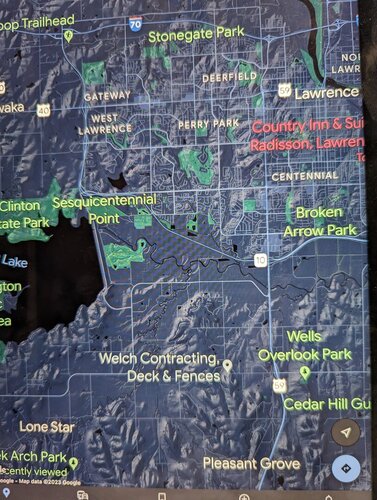
QUESTION: A question on Google Maps: I have found that small roads are nearly impossible to see on it because they are extremely low contrast. I've had it out in the Bradshaw Mountains area and really not been able to navigate well because of that. Delorme had great color choices. Apple Maps is better than Google, but not great.

Do you have a way around that, say, using it in dark mode or something?
 
I have not experimented with Google maps on my iPad lately so I don't recall if there are adjustments. It's possible dark mode might work or maybe different terrain backgrounds? Possibly turning down the screen brightness? Maybe someone else has more information?
 
I have not experimented with Google maps on my iPad lately so I don't recall if there are adjustments. It's possible dark mode might work or maybe different terrain backgrounds? Possibly turning down the screen brightness? Maybe someone else has more information?
I just did a bit of fiddling with Google Maps on my iPad Air.

It's pretty disappointing compared to Delorme.

But... I found that contrast is better in dark mode, with the screen reasonably bright. Terrain mode shows the small streets when zoomed farther out, but it also clutters it up with terrain, and at some zoom levels, funny little marks that I don't understand.

Image below (at a zoom without the little marks).
 

Attachments

  • PXL_20230511_001149526.jpg
    PXL_20230511_001149526.jpg
    266.3 KB · Views: 0
I don't know anything about apple stuff, but Android has a few different map programs that can be used offline (other than Google Maps). I've used Sygic and CoPilot. You could use them on a tablet or Chrome book. If you use grlevel3, you might be able to get away with using the latest road place files. I was a Street Atlas fan as well, but now use Waze and a Garmin Drivesmart for a backup when I'm out of cell range.
Just downloaded sygic on my android phone and my ipad. I have to say I'm very impressed especially since it's offline and very easy to see the roads (contrast) is great! This my number 1 navigation map for my ipad now! @Warren Faidley give this a try if you need a great backup for the ipad!
 
Just downloaded sygic on my android phone and my ipad. I have to say I'm very impressed especially since it's offline and very easy to see the roads (contrast) is great! This my number 1 navigation map for my ipad now! @Warren Faidley give this a try if you need a great backup for the ipad!
I am seriously considering Sygic for my iPads. Do you know what their map source is? Does it seem up-to-date with US roads?
 
I have posted this before, but I really like using RadarUS+ for the majority of chases. It has the radar overlay and the roads are relatively easy to see. I don’t believe the radar updates as often as Scope does though. I find it makes it easier to figure out which roads to take.
 
I have posted this before, but I really like using RadarUS+ for the majority of chases. It has the radar overlay and the roads are relatively easy to see. I don’t believe the radar updates as often as Scope does though. I find it makes it easier to figure out which roads to take.
Is this for android or apple?
 
I have posted this before, but I really like using RadarUS+ for the majority of chases. It has the radar overlay and the roads are relatively easy to see. I don’t believe the radar updates as often as Scope does though. I find it makes it easier to figure out which roads to take.
I use Radar Alive Pro (Android). But then I wrote it for chasers, and for my chasing. However, the map data is low resolution - just there to allow one to know where the meteorological phenomena are.
 
Back
Top