Tim Vasquez
EF5
- Joined
- Dec 4, 2003
- Messages
- 3,411
477.6 dam
January 21, 1985 Caribou, Maine
(Lowest on record in the conterminous United States)
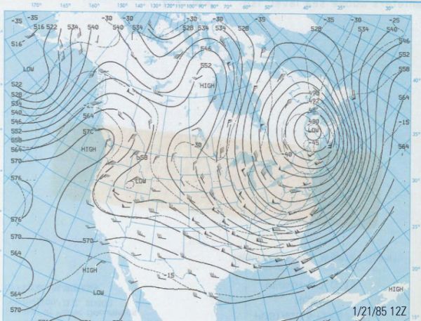
This deep upper-level low was associated with one of the biggest outbreaks of arctic air into the central U.S. of the 1980s. It also gave the all-time lowest 500 mb height for the conterminous U.S. The day before, Dallas saw a balmy 70-degree afternoon, and by 10 pm it was in the 20s with winds howling out of the north at over 40 mph.
A similar outbreak in 1982 (the month of the AFC Freezer Bowl) gave the second runner up of 478.1 dam on January 18, 1982 at 00Z, also at Caribou.
Tim
January 21, 1985 Caribou, Maine
(Lowest on record in the conterminous United States)
This deep upper-level low was associated with one of the biggest outbreaks of arctic air into the central U.S. of the 1980s. It also gave the all-time lowest 500 mb height for the conterminous U.S. The day before, Dallas saw a balmy 70-degree afternoon, and by 10 pm it was in the 20s with winds howling out of the north at over 40 mph.
A similar outbreak in 1982 (the month of the AFC Freezer Bowl) gave the second runner up of 478.1 dam on January 18, 1982 at 00Z, also at Caribou.
Tim