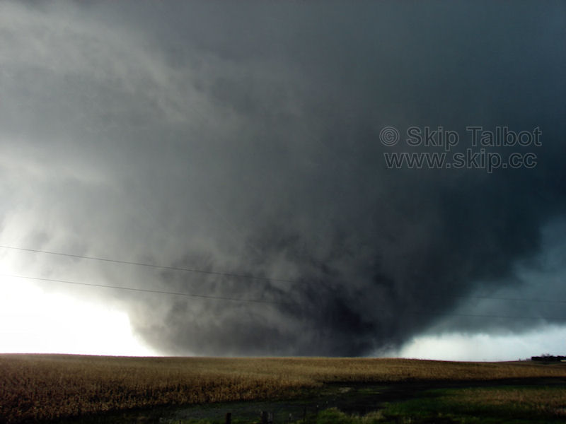
Is 2010 the most photogenic tornado year to-date?

There's no doubt whatsoever this year has been the best Alley-wide since 2004. But let's not forget about the slow start, especially for those of us near and S of I-40 who like to see a few decent/chaseable setups in March and April during good years. I was going insane by the time April 22 finally arrived, given that March and the first 2/3 of April were absolutely dead, even in TX. Granted, those of you farther N who don't expect anything nearby until mid-spring probably don't see this as much of a factor.

I'm not complaining at all. This was an outstanding season and mid May onward more than made up for the slow start, to put it mildly. But I think for the southern contingent here, comparing this March-May 10 to a year like 2007 holds 2010 back from being the ultimate dream season. I'm not sure there's ever been a season that started like 2007 and ended like 2010 in the history of chasing, though. And personally, I'll take a stellar May 10-June 20 over the rest of the year any day.

As for 2004 vs. 2010 head-on, very tough call. I wasn't out here until 2006, so 2004 holds this mythical status in my mind, probably skewing my viewpoint. The number of "dry" tornadoes offering clean views from just about any position in 2004 seems hard to match... Attica, Beaver City 5/22, N KS 5/24, Harper Co. 5/29, NW IA 6/11, and Mulvane just off the top of my head. Campo this year probably tops them all, of course. One thing I'll never get over is the May 10 setup, and how it shifted from the Panhandles to I-35 in the 48 hours leading up to the event. Had the dryline set up even 50 mi. W of where it did, I think a lot of us would have played along or S of I-40 and caught the incredible Norman or Ardmore tornadoes in chaseable terrain. That alone might've tipped my vote.

Shane raises a pretty good point, too. An apples-to-apples comparison against seasons from decades past is not really possible. A lot of the storms that made this year so memorable were isolated and difficult-to-forecast events far removed from the core KS/OK/TX crowd, and might well have gone unnoticed back in 1980 or maybe even 2000.
 
One thing that has now blown me away is the number of high-end/significant tornadoes this year. I'll continue to check records, and I am curious to see how 2010 ranks with other recent years in terms of the number of 4 rated tornadoes. The following is a list of the EF-4 tornadoes this year that I know of:

April 24th: Yazoo City, MS
May 10th: Norman/OKC/Shawnee, OK (2)
May 22nd: Bowdle, SD
June 5th: Wood County/Toledo, OH
June 17th: Wadena, MN; Albert Lea, MN; Holmes, ND; Almora-Bluffton, MN
June 25th: Sibley, IA

That's 10 EF-4s so far this year! Granted, no EF-5s, but that's still quite something.

Using ArcMap and the data available on the SPC site, I have come up with the following counts for EF-4 tornadoes by year for the past 25 years:

Year Count
1985 8
1986 3
1987 3
1988 3
1989 11
1990 12
1991 6
1992 12
1993 6
1994 5
1995 10
1996 2
1997 9
1998 6
1999 12
2000 3
2001 6
2002 5
2003 8
2004 5
2005 1
2006 2
2007 4
2008 9
2009 2
2010 (so far) 10

So it seems 2010 is certainly not at the top since years like 1989, 1990, 1992, 1995, and 1999 had that many or more tornadoes, but it's getting up there. There's still 6 more months of 2010 to go, also.
 
One thing that has now blown me away is the number of high-end/significant tornadoes this year. I'll continue to check records, and I am curious to see how 2010 ranks with other recent years in terms of the number of 4 rated tornadoes. The following is a list of the EF-4 tornadoes this year that I know of:

April 24th: Yazoo City, MS
May 10th: Norman/OKC/Shawnee, OK (2)
May 22nd: Bowdle, SD
June 5th: Wood County/Toledo, OH
June 17th: Wadena, MN; Albert Lea, MN; Holmes, ND; Almora-Bluffton, MN
June 25th: Sibley, IA

That's 10 EF-4s so far this year! Granted, no EF-5s, but that's still quite something.
A tornado north of Collinsville, AL also received an EF4 rating on April 24th. That makes it 11 EF4's this year.
 
Yet another amazingly photogenic tornado in western MN today. The trunk/slender cone was lit up blazing white with a dramatic debris cloud. It reminded me of Mulvane. I think 2010 is definitely giving 2004 a run for its money.
 
Yet another amazingly photogenic tornado in western MN today. The trunk/slender cone was lit up blazing white with a dramatic debris cloud. It reminded me of Mulvane. I think 2010 is definitely giving 2004 a run for its money.

I would agree but looking at Chad's picture it is looking almost exactly like Eric Nguyen's picture from the May 29, 2004 southern Kansas tornado machine.

Chad's Photo
http://www.stormtrack.org/forum/showpost.php?p=281333&postcount=2

Eric's Photo
http://www.mesoscale.ws/pic2004/040529-6.jpg

Either way that was an absolutely increduble tornado yesterday!

Something to note as well I think this season isn't over yet. We have just transitioned from a El Nino to a La Nina in a short time span. I decided to do a little research and found the few times this has happened, the fall has almost always been active. The most recent was the El Nino-La Nina transition of 1998-1999 which featured the impressive October 4, 1998 Oklahoma tornado outbreak among a few other notable events.
 
Last edited by a moderator:
Those photos are too eerily similar. So we have a Mulvane duplicate and a 5-29-04 duplicate.

When you consider other amazing storms such as the Bowdle and Albert Lea storms...I am putting 2010 ahead [given what I know of 2004 and since I didnt chase in the plains that year my knowledge may be skewed to only those key events.]

Until I see something with better tornado structure than the following images...2010 has my vote.

Seeing a tornado is great and any tornado shot can look amazing when zoomed and cropped, but to see the tornado and amazing structure from the parent supercell along with it is the winning icing on the cake.

6-8-18%2520IL%2520CO%2520OK%2520TX%2520MN%2520020.jpg


37454_402707238806_530973806_4621772_4721427_n.jpg
 
http://www.sciencefaction.com/?service=asset&action=show_preview&asset=2120

There's another structure tornado deal from 2004, May 29, but nc KS not sc KS. Course same day there was the whole beast in nw MO too. That and May 24 also had a beast over there. The one tornado video from KC chopper was INSANE. Violent beast. They showed some 6 inch perfectly round stones from it too, but that tornado was incredible.

Scott linked Roger's from May 22nd in sw NE...here is Davies from sc NE before Hallam.

http://www.jondavies.net/052204sne/052204sne.htm

Man I wish I could dig up something of those July 7 nc KS tornadoes and the supercells. I know the one was on that coast to coast site at one point lol. Insane structure and a tornado outbreak.

There's a lot to dig up from 2004. Wish I could track down that Gothenburg Nebraska tornado also from May 29.

May 16 http://www.stormgasm.com/5-16-04/5-16-04.htm

August 26 http://www.nebraskastorms.com/04_collegesprings.htm Pretty good structure on that thing in August producing multiple vortices.

May 21 http://www.usatoday.com/weather/news/2004-05-21-iowa-tornado_x.htm The mile wide Bradgate IA deal.

April 21 http://freepages.misc.rootsweb.ancestry.com/~fkruse/Tor04/Tornados_21_April_2004.html April 21.

May 23 http://www.crh.noaa.gov/ilx/events/may232004/chenoa1.jpg

April 20 IL/IN outbreak not that I can find any photos at the moment. http://www.crh.noaa.gov/ilx/events/apr202004/campgrove17.jpg There's one I guess
 
Last edited by a moderator:
April 20th in IL/IN was a structure fest, but unfortunately also a haze-fest. I got tired of digging it up, but someone has a really good shot of the supercell that produced the tornadoes that I saw near Kankakee in NE IL that evening. Okay fine, I'll look it up. Roger Look, that's who it was.

http://xa.yimg.com/kq/groups/1916491/sn/839548056/name/n_a

Someone may have also mentioned it, but I'm simply supplementing Mike H's most recent post. The Roanoke tornado in IL on July 13 2004 was also a photogenic dream. Okay, I see Weberpal hit 7/13, but this is my favorite "structure" shot of that storm:

http://www.crh.noaa.gov/ilx/events/jul132004/Eurekator3.jpg

2004 still has my vote. I know a lot are new, and since 2004 it's the first year that has really gone nuts so it may be the most insane some have personally experienced, but I still think 2004 takes the cake.
 
I am going to spend way too much time on this post...but here goes.

May 10th 04:
CedarPt4c-.jpg


May 10th 10:
051010146.jpg


May 12th 04:
attica5.jpg


May 12th 10:
20100512_182359.jpg


May 22nd 04:
2004_may_22_1.jpg


May 22nd 10:
10052224.jpg


May 24th 04:
04-5-24-1334.jpg


May 24th 10:
052410tornadochurch.jpg


May 29th 04:
040529-5.jpg


May 29th 10:
[this was a non tornado day in 2010 so Ill use the one from 8/7/10 for comparison]
962067920_WzMwo-XL.jpg


June 10th 04:
040610-14.jpg


June 10th 10:
6-8-18%2520IL%2520CO%2520OK%2520TX%2520MN%2520020.jpg


June 11 04:
04-6-11-17.jpg


June 11 10:
20100611_12.jpg


June 12 04:
040612-17.jpg


June 12 10:
uvs100612-001.BMP


OK thats as far as I am going with the side by side comparison.

Days in 2010 with great tornadoes that I can think of off the top of my head:

3/8
030810a_108.jpg


4/20
IMGP2008copy.jpg


4/22
DSCN0917.JPG


5/31
attachment.php


6/5
DSC_0632.JPG


6/17
37454_402707238806_530973806_4621772_4721427_n.jpg


If someone else with too much free time wants to step in and try to do a comparison be my guest. I am still sticking with 2010 as of now. This is kinda fun in a way to see how different years compare.
 
Last edited by a moderator:
Let's not forget March and April were mostly quite for 2010. In 2004 March and April had numerous tornadoes and some of them were monster wedges. Here is a few dates:
March 27: F3 wedge near Kinley, Kansas.
April 8, Roswell, New Mexico tornado shown on TWC.
April 19, Wedge tornadoes near Peyton and Pampa, Texas.
April 20, Big tornado outbreak in Iowa, Illinois and Indiana. A violent tornado hit Utica on this day. In Utica, Illinois 8 people are killed after a tavern collapses. This tornado destroyed half of the downtown and 100 homes. The tornado was given an F3 rating. There was 30 confirmed tornadoes that day.

Now let's look at May for 2004 which was one of the most active May's I can remember. I don't remember a May that beats 2004. Then again I don't remember much of the years before 2003. FROM MAY 21st to May 31st 389 tornadoes were confirmed! That is an 11 day period!


On May 21, 2004 an EF2 tornado damaged or destroyed all but one building in the town of Brad gate Iowa. I remember seeing nice photographs of that tornado. The next day a tornado outbreak occurred with 86 tornadoes reported. May 22 not only had the 2.5 mile wide F5 monster but I saw pictures of beautiful tornadoes in Iowa that day. Iowa could have seen over 30 tornadoes that day and I believe that day holds the record for most tornadoes seen in an outbreak for Iowa. May 26-27 had several tornadoes in Kentucky that caused a lot of damage.

May 29-30 had 168 tornadoes confirmed with more reported in just a 32 hour period. So in two days almost 200 tornadoes touched down. I have yet two see an outbreak like that in 2010. This rivals the Super outbreak of 74 where 148 tornadoes touched down in 18 hours. The tornado outbreak went from The Dakota's down to Oklahoma and east to Ohio, Tennessee and Mississippi. Two F4's and eight F3's occurred with this outbreak.

Now 2010 did have the record hail in Vivian, South Dakota. In 2004 on April 4, Seminole, Texas had Golf ball sized hail for almost an hour leaving hail a foot deep on the ground. For me having hail for almost an hour is just as spectacular as 8" hail.

Now I could post pictures like Adam did but I wont. Reason being I can probably find 2 times as many photographed tornadoes in 2004 than 2010. Unless 2010 has a spectacular fall I still will disagree on it being the most photogenic year ever.
 
Last edited by a moderator:
For comparison with the 2004 lists, here's a round up of 2010 tornadoes. Of course every tornado isn't posted here, and some are more photogenic than others, but hopefully this is a good cross section of the more photogenic events.

2/27 CA (spouts):
http://www.swseverewx.org/gallery/waterspout-1a.jpg

3/8 OK:
http://tornadocentral.com/chasing/2010/03082010/IMG_7436w_forum.jpg
http://www.cloud9tours.com/board3/files/030810a_108.jpg

4/7 IL:
http://www.stormtrack.org/forum/attachment.php?attachmentid=3594&stc=1&d=1270732537

4/20 TX:
http://img.photobucket.com/albums/v153/brandon14295/04-20-10bushland/IMGP2004copy.jpg
http://img.photobucket.com/albums/v153/brandon14295/04-20-10bushland/IMGP2008copy.jpg

4/22 TX/KS/CO:
http://violentplains.com/wp-content/gallery/april-22-2010/2010_4_22_currens18.jpg
http://i596.photobucket.com/albums/tt43/mikeparkerimages/Tornado/IMG_4203.jpg
http://i135.photobucket.com/albums/q122/not_a_leader_of_men/DSC_0144.jpg
http://lh4.ggpht.com/_MdHs8ZT9O98/S9FUftvIzEI/AAAAAAAAA6I/6hRihZFfmlc/s640/DSCN0932.JPG
http://lh6.ggpht.com/_MdHs8ZT9O98/S9FSa1SJuJI/AAAAAAAAA5w/efYWLNMyvUM/s640/DSCN0917.JPG
http://skip.cc/chase/100422/10042210.jpg
http://farm5.static.flickr.com/4045/4545171264_81dd6d500a_o.jpg

4/23 IL:
http://www.johnefarley.com/chase42310-HawkPointTor1.jpg

4/24 MS:
http://hphotos-snc3.fbcdn.net/hs397.snc3/24156_574437925455_82405481_33623212_3627862_n.jpg

4/29 KS:
http://img.photobucket.com/albums/v143/mikeperegrine/_MG_7628.jpg

5/10 OK/KS:
http://www.stormtrack.org/forum/attachment.php?attachmentid=3827&stc=1&d=1274123761
http://coloradostormchaser.com/Wakita%20OK%20MV%20Tornado%20w%20Satellite.jpg
http://www.chasetolive.com/gallery2/d/2348-1/CRW_5097_JFR_small.jpg
http://www.texasstormchasers.com/wp-content/uploads/2010/05/10/4.png
http://www.extremeinstability.com/stormpics/2010/10-5-10-3.jpg
http://www.stormtrack.org/forum/attachment.php?attachmentid=3789&stc=1&d=1273590682
http://img96.imageshack.us/img96/1449/051010145.jpg
http://hphotos-sjc1.fbcdn.net/hs568.snc3/30989_126196257393904_120109444669252_327125_5070022_n.jpg
http://hphotos-snc3.fbcdn.net/hs261.snc3/27734_385161034997_520264997_3967125_4340377_n.jpg
http://www.tornadofx.com/temp/051010tor04sm.jpg
http://www.stormchaserco.com/20100510_CherokeeOK_1.jpg

5/12 OK/KS:
http://hphotos-snc3.fbcdn.net/hs534.snc3/30299_1186609324128_1795142262_351726_934177_n.jpg
http://www.stormfever.com/Galleries/Storm Chase 2010/Tor1sm2.jpg
http://farm5.static.flickr.com/4053/4602770445_3089193048.jpg
http://www.underthemeso.com/blog/wp-content/photos/2010_0512_chaseOK/20100512_182359.jpg

5/14 TX:
http://www.tornadoeskick.com/images/2010/20100514_12.jpg

5/18 WY/TX:
http://i298.photobucket.com/albums/mm253/HesterMofet/18May2010/EastDumasTor1_2338Z_800x.jpg
http://www.tonightssky.org/images/051810b.jpg
http://sphotos.ak.fbcdn.net/hphotos...39441559306_1029161215_30764727_8078196_n.jpg
http://www.stormtrack.org/forum/attachment.php?attachmentid=3831&stc=1&d=1274306405
http://www.stormtrack.org/forum/attachment.php?attachmentid=3835&stc=1&d=1274307898
http://stormchaser.dk/images/stories/USA-2010/18. maj/IMG_9875_DxO_raw.jpg
http://www.stormfever.com/Galleries/Storm Chase 2010/18th/wc0006.JPG
http://www.bostonstormchaser.com/IMG_0711_1.jpg

5/19 OK:
http://1.bp.blogspot.com/_ABqhvJ55d...fWA/s1600/may182010leedeyoklahomatornado3.jpg
http://i298.photobucket.com/albums/mm253/HesterMofet/19May2010/Tornado5_E35_3_2304Z_x700.jpg
http://www.stormtrack.org/forum/picture.php?albumid=96&pictureid=611
http://www.stormtrack.org/forum/attachment.php?attachmentid=3845&stc=1&d=1274377057
http://farm5.static.flickr.com/4030/4624069745_3bf124a083.jpg
http://www.skyinmotion.com/gallery/photos/chase/2010/2010-05-19/2010-05-19_2971.jpg
http://www.underthemeso.com/gallery2/18720-2/100519_19143882.jpg
http://sphotos.ak.fbcdn.net/hphotos...417200386830_1137236911_31219092_583581_n.jpg
http://www.stormchaserco.com/20100519_Dashcam_T6_0001.jpg

5/20 TX:
http://sphotos.ak.fbcdn.net/hphotos...537458289081_196003355_31434382_7841327_n.jpg

5/21 WY:
http://www.tornadofx.com/temp/WY_tor02.jpg

5/22 SD:
http://dd.lebarinc.com/images/2010/052210.8.jpg
http://www.stormfever.com/Galleries/Storm Chase 2010/22nd/IMG_0242.JPG
http://www.harkphoto.com/05222010wedgetornado1.jpg
http://www.sky-chaser.com/image/mwcl2010/m11tor13.jpg
http://i117.photobucket.com/albums/o44/erikperozo/SDTorBW.jpg
http://www.skip.cc/chase/100522/10052224.jpg
http://www.skip.cc/chase/100522/100522vid05.jpg

5/24 SD/TX:
http://farm5.static.flickr.com/4016/4637209096_e2455c8cf5_m.jpg
http://www.harkphoto.com/052410tornadochurch.jpg

5/25 CO:
http://i117.photobucket.com/albums/o44/erikperozo/Towney.jpg
http://www.sky-chaser.com/image/mwcl2010/m11tor18.jpg
http://www.sky-chaser.com/image/mwcl2010/m11tor21.jpg
http://www.chasecaseco.net/wp-content/uploads/2010/05/May25TribuneTor2_small.jpg
http://farm5.static.flickr.com/4040/4641876864_31175f445e.jpg
http://eyeonthetwister.com/wp-content/uploads/2010/06/p1040461-3.jpg

http://hphotos-snc3.fbcdn.net/hs334.snc3/29300_1454999543477_1487975763_31193705_6357973_n.jpg
http://www.stormchaser.ca/Tornado_Chase_Logs/2010/2010_05_24E.jpg
http://www.tornadoeskick.com/images/2010/20100524vid_01.jpg
http://farm5.static.flickr.com/4006/4637346955_4fdd3e35f1_b.jpg

5/31 CO:
http://i128.photobucket.com/albums/p168/w1ndy357/Stormchasing/chase10/chas100001-4.jpg
http://www.underthemeso.com/blog/wp-content/uploads/2010/06/100531_19164080.jpg
http://img139.imageshack.us/img139/4210/img8412.png
http://farm5.static.flickr.com/4059/4659536802_ce4ce28a0e_b.jpg
http://wx3i.smugmug.com/Storm-Chasing/SC2010/TorRainbowSmall/888788008_MycHj-M.jpg

6/5 IL:
http://midwestchasers.com/blog2/wp-content/gallery/june-5-2010-central-il-tornadoes/elm005.jpg
http://www.nicknoltewx.com/wp-content/uploads/2010/06/vlcsnap-2010-06-06-21h28m40s191-275x206.png
http://farm5.static.flickr.com/4057/4673951086_0323608069.jpg
http://www.stormtrack.org/forum/picture.php?albumid=101&pictureid=629
http://farm5.static.flickr.com/4033/4673751049_c863c6c67c.jpg

6/10 CO:
http://hamwx.smugmug.com/Storm-Chas...ado-Tornadoes/IMG7185/897205714_R3ZpJ-M-1.jpg
http://texastailchaser.com/bloggerPics/2010/20100610/IMG_0968.jpg
http://www.skyinmotion.com/gallery/photos/chase/2010/2010-06-10/2010-06-11_3327.jpg
http://www.stormtrack.org/forum/attachment.php?attachmentid=4018&stc=1&thumb=1&d=1276247464
http://sphotos.ak.fbcdn.net/hphotos..._396304493806_530973806_4455782_7935017_n.jpg
http://www.stormchaserco.com/20100610_HH_T2.jpg

6/13 OK:
http://www.stormtrack.org/forum/attachment.php?attachmentid=4037&stc=1&thumb=1&d=1276517351
http://www.tornadoeskick.com/images/2010/20100613vid_02.jpg

6/16 SD:
http://www.extremeinstability.com/stormpics/2010/2010_06_16_5449.jpg
http://www.extremeinstability.com/stormpics/2010/2010_06_16_5438.jpg
http://photos.spiffypix.com/img/s8/v9/p747037526-3.jpg
http://photos.spiffypix.com/img/s9/v13/p392226564-3.jpg
http://photos.spiffypix.com/img/s8/v10/p428213207-3.jpg

6/17 MN/ND:
http://photos.spiffypix.com/img/s8/v10/p1061514759-3.jpg
http://photos.spiffypix.com/img/s8/v9/p596643949-3.jpg
http://1.bp.blogspot.com/_khiZske8DLQ/TBzr2HMCEyI/AAAAAAAABOA/QtRntFFPyKk/s1600/169.JPG
http://skip.cc/chase/100617/best10061701.png
http://skip.cc/chase/100617/best10061702.png
http://skip.cc/chase/100617/best10061703.png
http://tcs.net/michaels_blog/images/IMG_4625.jpg
http://tcs.net/michaels_blog/images/IMG_4506.jpg
http://tcs.net/michaels_blog/images/IMG_4488.jpg
http://www.f5hunter.com/6-17-10/6-17-10_kiester1.jpg
http://www.f5hunter.com/6-17-10/6-17-10_kiester2.jpg
http://www.stormtrack.org/forum/attachment.php?attachmentid=4074&stc=1&thumb=1&d=1276838868
http://hphotos-snc3.fbcdn.net/hs067.snc3/13433_533409167188_59700098_31558137_3655726_n.jpg

6/20 WY:
http://farm5.static.flickr.com/4028/4718534479_77d534c085_b.jpg
http://chasethestorms.smugmug.com/Other/Spring-2010/Grabbed-Frame-1HDR/908263675_Ud8mA-L.png
http://www.stormeffects.com/images/62010-ChugwaterTor5-428.jpg

6/25 MN/NE:
http://farm5.static.flickr.com/4082/4735631156_2512ac2300_b.jpg
http://www.caprockphotography.com/Tailchaser/20100625/IMG2114/913836838_8rcWG-L.jpg

7/14 MN:
http://xtremewx.com/IMG_7852b_small.jpg
http://farm5.static.flickr.com/4099/4796980008_50d5636755.jpg
http://skip.cc/chase/100714/10071407.jpg


7/22 WI:
http://farm5.static.flickr.com/4078/4820505646_d3560a1466_b.jpg

7/23 SD:
http://sphotos.ak.fbcdn.net/hphotos...45564110370_1571180910_31048830_2614278_n.jpg
http://sphotos.ak.fbcdn.net/hphotos...234031270634_677395633_13919486_1214832_n.jpg

8/7 MN:
http://www.wxchaser.com/pages/photos/2010/080710/080710a.jpg
http://chasethestorms.smugmug.com/Other/Spring-2010/august7aSIZE/962067920_WzMwo-XL.jpg
http://chasethestorms.smugmug.com/Other/Spring-2010/august7bSIZE/962069946_xLaZm-XL.jpg
http://i38.tinypic.com/2rzcnj9.jpg
http://i34.tinypic.com/2ymvz85.jpg
http://www.mnwxchaser.com/2010images/10august07/20100807-_DSC0048.jpg
http://www.mnwxchaser.com/2010images/10august07/20100807-_DSC0080.jpg
 
Last edited by a moderator:
Wow Skip lots of work done there! Awesome pictures but one day I noticed you didn't have that had some very impressive tornadoes was May 23 in the TX Panhandle.

http://www.youtube.com/watch?v=YmA0CNNVizE

Also a few more lesser known tornadoes from the April 22 outbreak that my dad and I intercepted in W Kansas the first was NW of Deerfield, KS. The second image was another tornado about 15 minutes later well SW of Friend, KS.
4April22.jpg

5April22.jpg
 
Well, with the comparison lists now it's more becoming a debate of "what year did more chasers see tornadoes?", which obviously with the exponential growth of chasers in the field, 2010 would win. The lists are becoming more "tornado day" based, and not "photogenic" as earlier focused. My July 22nd Wisconsin tornadoes as posted in Skip's 2010 list are in no way a classic photogenic example I don't think.

Imagine if we had 25-30 chasers on every single storm in the high plains in July and August of 2004.

That image H posted is about as badass as a tornado and structure get... http://www.sciencefaction.com/?service=asset&action=show_preview&asset=2120

That June 10 2010 CO storm is cool, but also reminds me a lot of the April 24 2007 Nickerson KS storm. Classic structure, with photogenic but weak tornadoes underneath. That above photo with classic structure and a mean wedge underneath is hard to beat. It'd be like if Adam could combine his June 10th structure with the June 17th tornado into one storm.
 
Last edited by a moderator:
IMO if you can see it in a photo its photogenic lol some are just clearer than others. Defining photogenic is a matter of ones own personal definition. For those photogs who desire a dreamy, clear view like the tornado in MN the other day...those rare treats are it...but for some the chaotic scuddy motions of black HP wedge monsters offer a unique photographic opportunity.
 
Back
Top