Irene

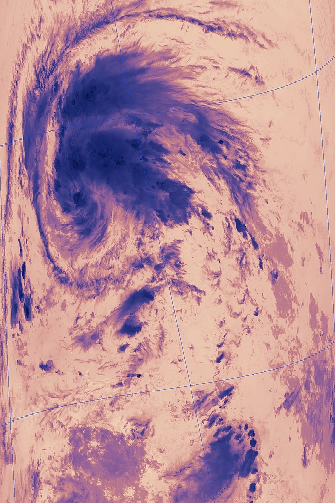
Irene caught by the Terra/Modis satellite in IR

band311.A2011233143500-2011233144000.2km.jpg
 
2 major ifs I am looking at... Irene must survive the island chain and two its gotta go somewhere other than Cuba>South Florida(which would not give it enough time to restrengthen. The 00z ECMWF, 12Z HWRF, and 12Z GFS have a track up the coast towards the Carolinas as a major storm... while the 12Z GFDL takes it into the Miami region as a weaker system.
 
with the center reforming 60nmi further north it now seems as if a track across Puerto Rico and possibly north of Hispaniola with little to no land interaction is becoming more likely. This scenario, if true, would lead to Irene having very little land interaction and a long time over warm waters of the Bahamas and the gulf stream as she tracks toward the Carolinas, Georgia, N Florida areas...likely as a major hurricane. several models have began to pick up on this possible track. Certainly needs to be watched very closely by all living in those areas.
 
Looks like a real nail-biter for the NHC.

The latest model ensembles are hinting of multiple possibilities in regards to strength and path. Some possibility of skirting the Florida, SC and NC coastlines before heading in. A very wide are may need to be on alert beginning on Tuesday.

I'm not really impressed with the 18z model groups concerning strength as most are keeping Irine around Cat. 1 intensity through 100 hours. It will be interesting to see if the eastward push and lack of land friction influences the next model run.

Target ATM would be from Daytona Beach, FL to Wilmington, NC with Savannah as the center point.

W.
 
It looks like it may miss the major mountains all together... would make for a possible beast heading for the CONUS.

Agreed on the nail bite factor!
 
The USAF Reserve aircrew in Irene now just sent a VDM (Vortex Data Message) indicating 66 knot surface winds and 993 mb surface pressure, meaning we know have Category 1 Hurricane Irene. The NHC should make it official at 11. For anyone watching in real time, you can get a really good view of Irene's structure by using the KJUA radar site (San Juan, PR). Irene should make landfall on Puerto Rico later tonight. After that, if it continues its current motion, it might miss Hispaniola all together and just go nuts on the Bahamas. Everyone from pretty much anywhere in Florida to North Carolina needs to take this very seriously.
 
Looks like Irene has only gone up to 70 mph. She definitely has a nice banding feature setting up on the northwest side of the circulation. Hope she misses the bigger mountains on the west side of Puerto Rico.
 
Aside from the obvious danger to the FL-NC coastline, it's also worth noting that the GFS keeps Irene's remnants fairly well-organized and spits out 24-hour precip totals up to about 9-10" all the way up the seaboard, including the Northeast corridor from NYC down through NJ to Philadelphia. If anything slows it down along the way (i.e., if the high over the southern Plains were to edge eastward), could there be a Floyd-like scenario?
 
If Irene takes a track like NHC has it from the 03z advisory, Jacksonville FL
may well get sustained hurricane force winds, which is extremely rare for that
city. It has has happened only one other time...Dora on 9/10/1964.

First landfalls on the GA coast are also extremely rare. Here is the last major one.
http://en.wikipedia.org/wiki/1898_Georgia_hurricane

And only two hurricanes made their first landfall in GA in the 20th century.
http://weather.unisys.com/hurricane/atlantic/1947/8/track.gif
http://weather.unisys.com/hurricane/atlantic/1979/DAVID/track.gif

The 1979 David track is actually a pretty good analog to the current forecast
track later on. The only difference is David was a Cat 5 hurricane before hitting Hispaniola,
and it weakened to a strong TS briefly after re-emerging over water. It never regained
it former status. Irene is forecast to only skirt the N coast of Hispaniola, however,
this still can be quite detrimental to a system's low level circulation as the southerly
inflow on the storm's W side gets severely disrupted over the island. This is what
happened to Jeanne in Sept 2004.
http://weather.unisys.com/hurricane/atlantic/2004/JEANNE/track.gif

In fact, Jeanne's low level circulation got so disrupted that I believe the original one
literally got spit out of the mass of re-orgazining convection as it was pulling away from the
nrn Haiti coast. Vis sat imagery showed this little low level swirl flying WSW towards
ern Cuba! A new center reformed in the mass of convection to the N. I think I have a
sat image of this somewhere. I'll post it if I can find it.

The main point here is if Irene is held back from getting intense by land interaction now,
that just leaves it more likely to go to town later on, like when approaching the FL Coast?
An intensifying hurricane at landfall is *far* worse than one of the same intensity that is
steady state or weakening one at landfall. This is due to stronger updraft/downdraft couplets
in the eyewall, which push down the extreme winds found only a few hundred meters above
the sfc down to the ground. This is why Hurricane Andrew was so devastating...it was rapidly
intensifying at landfall.
 
Last edited by a moderator:
Looks like Irene just put an end to that, TJUA is down now.

Yup, I just noticed that too. The TDWR out of San Juan (TSJU) is still working, though. So, if you have GR3, you ca still watch the progress of Irene across the island.

It's rather startling to see some of the model forecasts for this system. There are some (like the 18z 3km WRF) that having a major hurricane raking nearly the entire eastern seaboard of Florida. The GFS forecasts from the past few runs have been showing a similar general track along or just off the east coast of Florida and southeastern GA (with landfall spots fluctuating). If Irene manages to miss most of Hispaniola, Irene could be a doozy for residents of the southeastern U.S. coast.

Edit: The 00z Hurricane WRF has a 926 mb, 109 kt hurricane poised to make landfall somewhere near the Charleston area ~5 days from now. The 00z GFDL is still forecasting a landfall on the western side of Florida, though it's been too far south thus far in its past forecasts for Irene. The GFDL is the outlier, however, with most of the other major models indicating direct effects from Irene on the eastern coast of FL, GA, and SC. Model data from FSU's Experimental forecast Tropical Cyclone Genesis Potential Fields
 
Last edited by a moderator:
Loving how well the eye looks on radar. I do wish both were still up in PR. Still early morning for me...so haven't take an in-depth look.

Welcome HURRICANE Irene. Cane chasers are liking the overnight progress (and residents very much NOT)! I am going to try and be out of the house by late afternoon Tuesday (from DC) if S. Florida looks to be a target. I may be able to push back some if the storm does this Carolinas route. I'm not convinced about the forecast track just yet...but there is a significant amount of shrinkage on the places Irene could go.
 
HUGE shift East on the latest advisory (#8) from the NHC which places a CAT3+ into SC.

This is giving me logistics problems in trying to intercept Irene from the UK - where to fly to?
 
Goodness, the 11AM advisory has the mean track showing landfall of a major hurricane right here in Charleston at 8:00am Saturday. Already some buzz going on here about the possibilities. My wife owns a retail shop with her plate glass storefront facing to the southeast, so we're already looking into the logistics of boarding up should it become necessary later in the week.

As the forecast track keeps shifting to the right, I think one distinct possibility is the storm may curve out to sea altogether, maybe just brushing the Outer Banks of NC on its way. I've seen this happen many times while living on the southeast coast. Because of the curvature of the coastline, a storm really must "thread the needle" to actually strike places like Jacksonville, Savannah or Charleston.

Of course, the last "big one" folks around here remember was Hugo, which landed just a few miles up the coastal highway (U.S. 17) in the tiny village of McClellanville, SC.
 
Last edited by a moderator:
Back
Top