Intense storms in Israel. Is this a supercell?

Joined
Apr 8, 2004
Messages
71
Location
Jerusalem, Israel
Hello everyone,

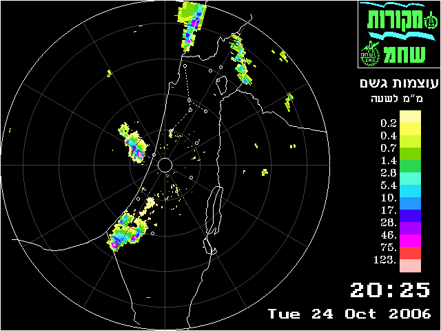
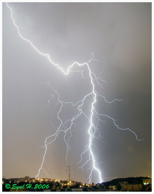
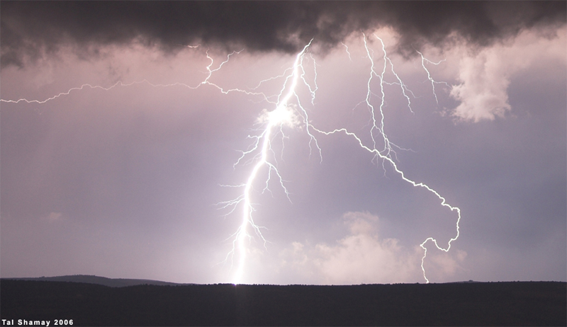
In the last 24 hours intense thunderstorms developed in Israel as a result of a classic meeting between the tropical-nature surface Red Sea trough and a cold upper-level European trough. The storms had intense lightning, reaching a bolt a second and even more, for quite a long time. Ben-Gurion airport recorded 60 mm of rain in 40 minutes, which is around twice the October average. Hail up to 3 cm was recorded in some places.

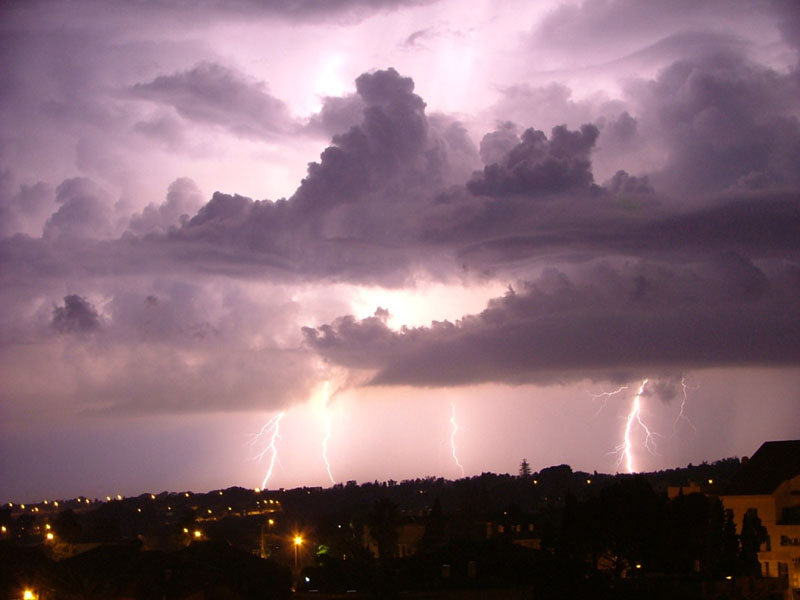
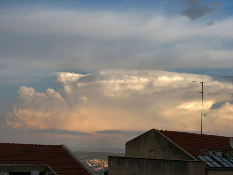
Now to my question. Is this Cb a supercell? Note the striations. I cannot tell whether the cloud rotated or not. Does such a formation always indicate cloud rotation or is it inconclusive? In any case this storm was highly electric and for some time had 2-3 bolts per second.

1_88080370.jpg

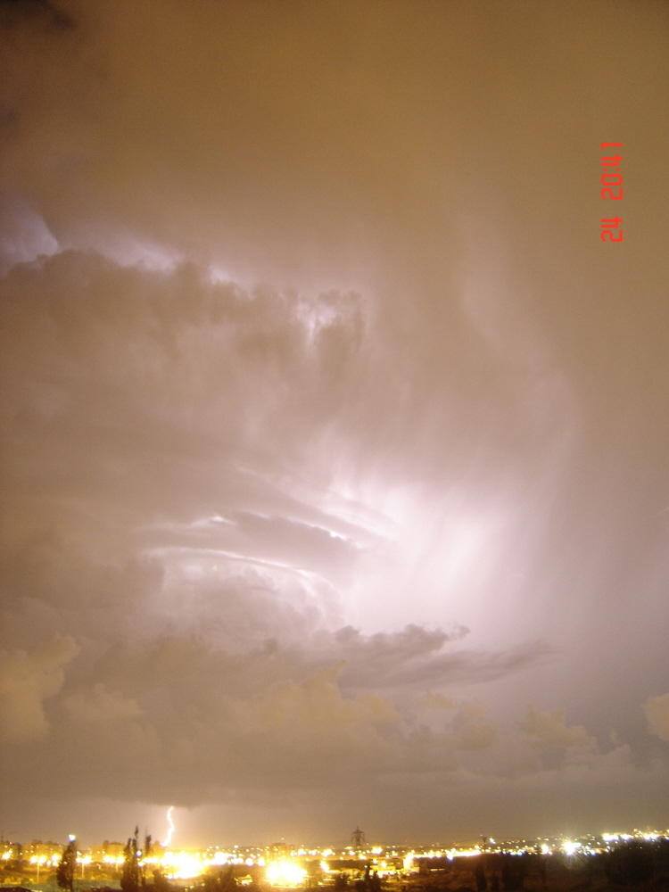
(photographed by Shay Agam)

1_88034763.jpg


1_88034838.jpg


1_88037522.jpg

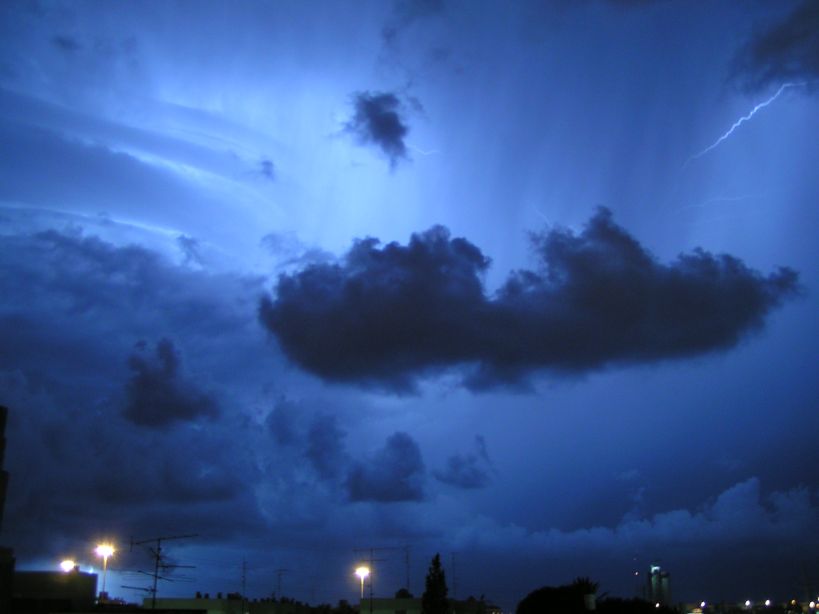
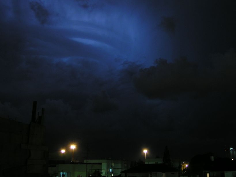
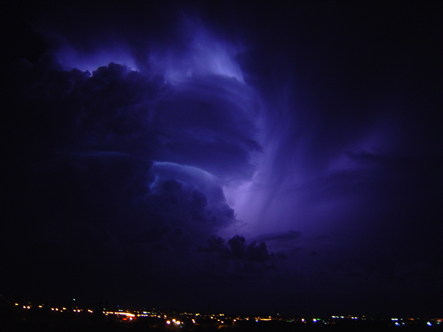
(previous 3 photographed by Yaniv Riz)
 
Last edited by a moderator:
Generally, striations indicate rotation, but I will not say that the clouds were rotating based solely on the striations. A radar image from the event would be helpful, as would video.

It would be considered a severe storm in the US with hail of that size.

If the storm was rotating, then yes, it was a supercell.
 
If the storm has striations then, by quite good hand, it is rotating. Unless, it is some scud cloud interference, or junk cloud. Those striations look like they have a sufficient, and long lived life-span based on your photo exposures, therefore that would lead me to believe that it is in fact a rotating supercell. By the way, on the first picture underneath the base, I see what looks like to be a funnel.
 
If the storm has striations then, by quite good hand, it is rotating. Unless, it is some scud cloud interference, or junk cloud. Those striations look like they have a sufficient, and long lived life-span based on your photo exposures, therefore that would lead me to believe that it is in fact a rotating supercell. By the way, on the first picture underneath the base, I see what looks like to be a funnel.

"By good hand" you may be right about the rotation, but there is no way of telling that it had a "Long lived life span" by looking at a few pictures, unless they were taken some time apart. What do you mean "unless it is some scud intereference, or junk cloud?" Pretty obvious to me that it is neither of what you say, and that the striations are part of the main updraft.

Definition of a supercell by Chuck Doswell:
http://www.cimms.ou.edu/~doswell/Conference_papers/SELS96/Supercell.html
"....deep, persistent, mesocyclone"

That hardly looks like a funnel, and it surely isn't something even pondering about.

Anyways, great pictures, I love the striations, and based on what I see, it looks like a very nice storm!
 
Hi David,

As you noted the striations are very apparent and probably indicate rotation and a supercell. In any event, those are some wonderful pictures!

Just for my own interest, does Israel experience most of its tornadoes in the fall/autumn?

Pat
 
The weather setup was rather atypical for supercells, a very barotropic situation under an upper level low. Look at the sounding: http://weather.uwyo.edu/cgi-bin/sou...AR=2006&MONTH=10&FROM=2500&TO=2500&STNM=40179

This has very large CAPE for this part of the world, and very little wind throughout a deep layer. In fact this would be perfect for landspouts and waterspouts together with the steep low level lapse rates and buoyancy, to help vortex stretching. However, such storms may give a sense of rotation when the happen on a wind jump line. Surface plots showed weak eastern winds, then a 20 kts western winds (gusts probably) and then again weak eastern winds. The storm remained still for hours on the coastline as far as I could see from the satellite image loop.

I think you will enjoy the idea that another upper cut-off low is sinking down your way later this week. Perhaps you could add any severe weather reports to the European Severe Weather Database... you may be Israel, but anyway, you share the Mediterranean... ;)
See the ESTOFEX site.

Oscar
 
By the appearance of the updraft and striations, not to mention what looks like both lower and mid level inflow tails, I'd say yep, you've got a nice little supercell there. I don't think you can really say that the striations and inflow tails ALWAYS indicate rotation (after all, there is no always or never in weather), but they are pretty decent indicators.
Congrats on that beautiful storm, David!!
 
It's hard to tell from the photos, which are very nice btw.

The "....deep, persistent, mesocyclone" explanation on Doswell's site is a little misleading because to detect something like this you need some kind of doppler observation in the first place.

As a more practical guide, I always ask if a storm has severe effects, because this is what is produced by a deep meso. Also the storm needs to be around for at least more than 50-40 minutes. I see you mention some fair sized hail and strong rain.

On Oscar's skew-T there's definately sufficient atmospheric instability. But I don't see very much shear.

In my view it seems to be some type of large tropical storm, of the type commonly experienced in equatorial regions of the world?
 
Last edited by a moderator:
Thank you all for the replies.

As a more practical guide, I always ask if a storm has severe effects, because this is what is produced by a deep meso. Also the storm needs to be around for at least more than 50-40 minutes. I see you mention some fair sized hail and strong rain.

The storm lasted two hours at least. And I must correct my initial report on the rain: 60 mm were measured in 40 minutes, not 3 hours. That's even more impressive...
Here is a rain radar of the storm (it is the one in the center-left). The colors are mm/hour.
1_88030095.png


Just for my own interest, does Israel experience most of its tornadoes in the fall/autumn?

Israel experiences very few tornadoes. The strongest thunderstorms, largest hail and most of the documented supercells occur during autumn, especially October. Spring ranks second. Of the few tornadoes that were documented some occured in spring, some in autumn, and some in winter. Last year we had an F1/F2 in April (I reported it here).

I think you will enjoy the idea that another upper cut-off low is sinking down your way later this week. Perhaps you could add any severe weather reports to the European Severe Weather Database... you may be Israel, but anyway, you share the Mediterranean... ;)
See the ESTOFEX site.

Hi Oscar! I've been monitoring the next storm system for several days now. Actually there is no end in sight, as ECMWF is now predicting another major storm two days after the next one passes us. I'll be glad to add reports to the database. Can I add them days after they occured or is it only for current reports?


Here are some more photos from the recent outbreak in Israel:

Lightning over Haifa:
1_88126237.jpg


Waterspout in Tel-Aviv:
1_88093931.jpg
 
Last edited by a moderator:
and some more photos from the outbreak:

Severe thunderstorm over Netanya (photgraphed by Tal Barnea):
1_88126478.jpg


Lightning over Tel-Aviv:
1_88126795.jpg


More lightning in central Israel:
1_88127481.jpg


Severe thunderstorm east of Haifa (photographed by Rafi):
1_88127978.jpg
 
Last edited by a moderator:
Hi David,

The radar image you show does have a core with a notch. I believe under weak wind conditions we simply may have another type of supercell that starts to rotate from stretching of pre-existing vertical vorticity. I know some more examples of rotating wall clouds observed in the Netherlands, with minimal shear.

I'll be glad to add reports to the database. Can I add them days after they occured or is it only for current reports?

The database is open to anyone and meant for permanent archival and easy access and ordening for people who want to study such cases. It makes it possible to do pan-European studies. So please submit, no matter the date. If you submit them within a week, they will be marked on the ESWD default map that everyone will see.

Waterspout in Tel Aviv:

Nice tube, pretty close!
I saw last weekend already that you would get the perfect waterspout conditions there. I even told my sprite observation colleage in Tel Aviv to keep an eye on the sky for spouts, but she is at the university in a room without a view :( 
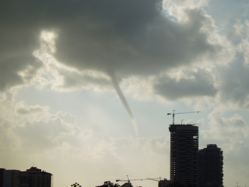
I just updated my spout forecasting parameter map. It shows good potential in green lines. Larger, contiguous areas should be indicating favourable conditions for them.
And this thunderstorm you posted was the reason they wouldn't install the camera on the roof for sprite observations!
Last December I was there myself for one week. Pretty stormy weather, though no luck with the sprites (or spouts).

Oscar
 
Last edited by a moderator:
There is a cap cloud in the top right of the first photo.

Again, great pictures, David!

Pat
 
Back
Top