Good day all,
Myself and a few other chasers took our chances and chased in Puerto Rico for Hurricane Maria. This was a pretty interesting hurricane chase, and full details are below...
Summary: This area shows pictures taken from the interception and observation of powerful category-four (borderline 5) hurricane Maria in southeastern Puerto Rico from its landfall on September 19 and 20, and subsequent destruction and aftermath. Hurricane Maria was a deadly and powerful hurricane that made its way across the Atlantic from the Cape Verde Islands off Africa in the middle of September 2017. East of the windward islands, it quickly intensified, and reached category 5 strength, with 160-165 MPH winds, and struck Dominica during the night of September 18. After devastating the islands, it continued WNW towards Saint Croix and Puerto Rico a day later, reaching a staggering 175 MPH as it approached Puerto Rico. Eyewall replacement and concentric eyewalls caused the storm to weaken a bit, but widen to a larger storm with 155-160 MPH winds as it made landfall just before dawn near El Negro, Puerto Rico on September 20. The storm ripped across the island in a diagonal path, from southeast to northwest, exiting northwestern Puerto Rico as a strong category 3 storm with 120 MPH winds early on the 21st. After striking Puerto Rico and clearing the Island, the storm went back out to see to the north of Hispaniola and brushed the Turks and Caicos Islands around the 22nd. The storm began moving northward, and passed east of the Bahamas and US East coast from the 23rd onward. Continued weakening occurred to east of the USA coast, and became a tropical storm late on the 26th (or early 27th) of september. Moving slowly, but eventually recurving out to sea, Maria continued weakening and became extra-tropical, ending its week and a half rampage across the western Atlantic. For me, this chase started with me flying from Miami to San Juan, Puerto Rico late in the day on September 18 (after cutting short a vacation in Chicago, which was supposed to last until the 21st). On the 19th and the 20th, I headed out of San Juan and rounded the east coast of Puerto Rico, ultimately winding up near El Negro and Palmas Del Mar. I headed back a bit to Humacao, then settled in Caguas for the main part of the storm and eye. After that, I headed back to San Juan once conditions permitted, reaching that area late on the 20th. I spent the remainder of my stay with storm chasers Brett Adair, Brandon Clement, and Caleb Eliott at their hotel (Condado Vanderbilt), which had food, water, and generator power. With flights cancelled, including my return on the 22nd, I eventually made it out of there on an unscheduled humanitarian flight with Brett and Caleb to Newark, New Jersey late in the day on September 24. Brett Adair wound up leaving this flight in a medical emergency (possible kidney stone), as I spend the night in New York with a friend, and finally made it back to Fort Lauderdale, Florida late on September 25. The total mileage on the rental car was about 150 miles, left with minor damage at the airport after being unable to find the off-airport return location in flooding, blocked roads, and no cell service. Power may be out in many areas in Puerto Rico for six months. Hurricane Maria was the worst storm to hit the island in 85 years.
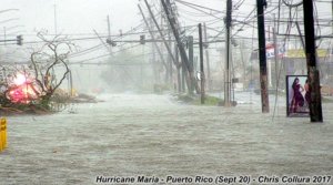
This is a view of Highway 1, a major route through Caguas, Puerto Rico, as the winds and rain from Hurricane Maria was winding down during the morning of September 20, 2017. Not only were the 150+ MPH wind gusts bad enough, but flash flooding also became catastrophic, with between 35 and 40 inches of rain falling in this area alone. Puerto Rico face a long and daunting recovery, with power out for at least 6 months in some places, and flooding / wind damage of catastrophic proportions.
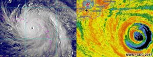
These are two images showing hurricane Maria as it was approaching Puerto Rico on September 19-20, 2017. The left image is a visible satellite image as the hurricane moving between the Leeward Islands and Puerto Rico as a category 5 hurricane. To the right is the San Juan radar site's base-reflectivity image of the concentric eyewalls approaching. This radar site will subsequently be destroyed as the storm crossed Puerto Rico on the 20th. The cross-hairs show my GPS location at the time, waiting for the arrival of the storm core by morning.
Full video of Hurricane Maria is below...
Pictures are below...
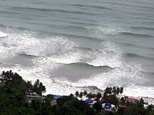 Above:
 Tremendous waves (southeast swell) impacting the coast, viewed looking down from a high cliff near El Negro during the evening of September 19.
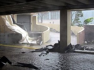 Above:
 View of roof fragments, trees, and debris slamming the entrance of the parking garage of the Las Catalinas Mall in Caguas, Puerto Rico during the morning of September 20.
 Above:
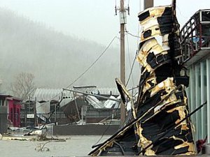
 Debris and structural damage of Highway 1 through Caguas, Puerto Rico during the late morning of September 20. Note the stripped trees on the mountain in the background!
 Above:
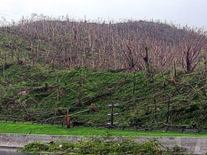
 View of mountain that was stripped of trees and vegetation north of Caguas, Puerto Rico during the late afternoon of September 20 west of Highway 52.
 Above:
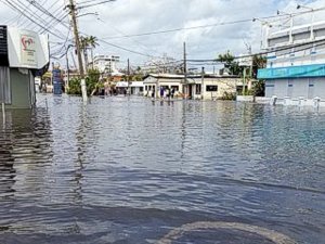
 Impassible roads and severe neighborhood flooding near and along Highway 3 into San Juan near Atlantic View on September 22. Blocked roads made for a trecherous and frustrating re-route all the way around Highways 26 and 17 westward with almost no fuel left.


