• After witnessing the continued decrease of involvement in the SpotterNetwork staff in serving SN members with troubleshooting issues recently, I have unilaterally decided to terminate the relationship between SpotterNetwork's support and Stormtrack. I have witnessed multiple users unable to receive support weeks after initiating help threads on the forum. I find this lack of response from SpotterNetwork officials disappointing and a failure to hold up their end of the agreement that was made years ago, before I took over management of this site. In my opinion, having Stormtrack users sit and wait for so long to receive help on SpotterNetwork issues on the Stormtrack forums reflects poorly not only on SpotterNetwork, but on Stormtrack and (by association) me as well. Since the issue has not been satisfactorily addressed, I no longer wish for the Stormtrack forum to be associated with SpotterNetwork.

    I apologize to those who continue to have issues with the service and continue to see their issues left unaddressed. Please understand that the connection between ST and SN was put in place long before I had any say over it. But now that I am the "captain of this ship," it is within my right (nay, duty) to make adjustments as I see necessary. Ending this relationship is such an adjustment.

    For those who continue to need help, I recommend navigating a web browswer to SpotterNetwork's About page, and seeking the individuals listed on that page for all further inquiries about SpotterNetwork.

    From this moment forward, the SpotterNetwork sub-forum has been hidden/deleted and there will be no assurance that any SpotterNetwork issues brought up in any of Stormtrack's other sub-forums will be addressed. Do not rely on Stormtrack for help with SpotterNetwork issues.

    Sincerely, Jeff D.

Garmin 376c

Joined
Jul 29, 2004
Messages
99
Location
New Jersey/Iowa
I have been thinking about purchasing a Garmin 376c but am somewhat skeptical (due to my experience with the C340) on its functionality as a WxWorx replacement.
I was wondering if anyone has any chase experience with the device and would be willing to answer a couple detailed questions either via posting or through PM.

Thanks,

Alex Fisher
 
Its wonderfull. Its a backup system for me when we dont have alltel phone data but I am always using it for its gps which I have the travel pkg that has the detailed maps. Its really nice having it right in front of you not having to open windows etc to see exactly what road your on and what road you need to get on. Anyone who has seen it in action would probably want it. 20$ a month is also nice for the radar and a little bit more while for like 50$ you get radar, lightning, satellite, storm cell attributes, warnings, forecasts. Its also neat to have xm radio as well which I didnt have until I bought this.
 
Thanks for replying Brian,

Got a few questions:

1. One of the major problems with my current Garmin GPS (C340) is that it is impossible to change the area at which one is looking without zooming out, which then decreases the level of road detail. This may be because of the touchscreen interface. How is the 376c at scanning the map at a single zoom level. Does it have a directional pad that allows this?

2. Is the resolution/size acceptable for chasing? (i.e. is there ever any problem making out the roads while the radar is turned on?)

3. Is it a reasonable alternative to WxWorx (considering that I have a mac and would have to buy Windows and then WxWorx)?

4. Does the radar update quickly enough for chasing or is it slower than WxWorx?


Thanks,
Alex
 
Yes it does have a direction pad to move your viewpoint from centered on your gps location to wherever you want to move it to...all you do is press one of the directional arrows and off you go.

We have never had any problems with seeing the roads.

I have a laptop so I could have gotten wxworx for about the same price and I would do it again the same way (although again I am using this as backup to having the alltel high speed and using grlevel w/allisonhouse)

The radar is updated pretty good but when you have grlevel running right behind it you will notice that it seems to be 5-10 minutes behind that.
 
Thanks man!
You've been really helpful and I appreciate you taking the time to answer my questions. I'm leaning strongly toward getting one, just wanted to make sure it could actually work for chasing.

-Alex
 
Well I think its great. I probably wouldnt have got it if not for seeing George Flickinger's when he got his and being in awe. Its definately worth it...especially if you would have to get a computer too.
 
Thanks for replying Brian,

Got a few questions:

1. One of the major problems with my current Garmin GPS (C340) is that it is impossible to change the area at which one is looking without zooming out, which then decreases the level of road detail. This may be because of the touchscreen interface. How is the 376c at scanning the map at a single zoom level. Does it have a directional pad that allows this?

2. Is the resolution/size acceptable for chasing? (i.e. is there ever any problem making out the roads while the radar is turned on?)

3. Is it a reasonable alternative to WxWorx (considering that I have a mac and would have to buy Windows and then WxWorx)?

4. Does the radar update quickly enough for chasing or is it slower than WxWorx?


Thanks,
Alex

I also have a Mac- I chased with Brian and I must say I was VERY impressed with the garmin. The only thing it has that the "regular" Wx Worx has that this does not are the "whirlies" that indicate shear.

I do have one question though for Brian that I just thought of- the files that are needed to get the really high detail level
at close range- are those downloaded to a PC, and then into the Garmin? How many states can you do at a time, and how would that work using a Mac?
 
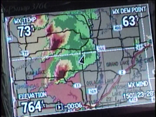
Garmin pic

From another thread....Here's an "action" shot of a Tornado Warned storm in Osage Co. Oklahoma.


garmin_a.jpg


I have mine set up to display the nearest metar data. The time stamp at the bottom (-00.06) shows how old the data is.
 
Last edited:
For street level mapping, you'll need to purchase the extra map data kit. You transfer the maps from PC to the Garmin via included USB cable.

I give the product an "A" rating. I usually leave the scanner and laptop in the trunk now on most chases.
 
I may actually end up not getting it. I dont like the idea of paying an extra 250+ dollars for a memory card and the same maps that came with my 200 dollar gps. I also see that the biggest memory card available for it is 512mb and even the leanest set of maps takes over 1gb to cover the US. Thusly there is actually no way for me to put the entire US on it. I drive around the entire country and I also live in NYC, which may be the largest map in entire set (further limiting the amount of maps I can put on it). Simply put, I feel they are bilking the consumer by making it physically impossible to place the entire U.S. on there. Furthermore, it seems to require a PC and my boot camp windows xp is pretty cranky right now, so I dont want to rely on it. I just cant get over the fact that my cheap-ass GPS comes with better maps built in and this 700 dollar machine does not.
 
Post #1
Greetings! As a new member, I thought I would add my opinions on the merits and problems of using the Garmin 376/378/478.

We have a lot of new members here and I'm sure that selecting their equipment is a high priority. Last year I bought the 376C (and XM WX Mariner subscription) to start my storm chasing career. In summary, I found that it did not give me enough information to locate the area of initialization or to help me make the decision to change targets when several cells are active in the area.

In conjunction with the Garmin 376C, I used a wifi-enabled laptop and internet web sources. I stopped for data at 10am, 1pm, and 4pm if possible. What a pain as I scurried about looking for WIFI sources in the fields of Kansas and Texas!

For the May4-5, 2007 chase, I bought the Verizon EVDO 595 Aircard to give me constant bandwidth to my laptop and the GRlevel3 software. Even though I have yet to see my first tornado, the GRlevel 3 gives me more information and helps me make better decisions. The "National Access" worked continuously throughout my chase in Kansas.

After getting yourself inside the convective outlook area, you need to find the area where convection will occur. I found the placefile overlay function of GRlevel3 very helpful getting me in the right area. The 376C is very good at showing Base Reflectivity, but if you don't happen to be close by, you waste valuable time getting to it.

When you're in the heat of the battle, your main target may fizzle out or a cell nearby may start rotating. The 376C isn't much help. On the GRlevel3, I get boxes showing which cells are tornado warned, which cells are rotating and which cells have already produced a tornado (storm report). The 376C at most shows the counties that have become tornado warned, but they don't show you which cell caused the warning.

On a positive note, the 376C is great at mapping you a route to a new destination. Push a few buttons and in an instant you can see how long it will take you to get to that cell in a neighboring county. It also shows you cell strengths and heights, surface level pressure contours, wind direction and limits you to main roads (keeping you out of the mud) since it's internal memory contains only the main roads.

Good Luck with whatever equipment combination you use!
 
Back
Top